![](/images/other/stat-length.png)
![Trail Walking La Valette-du-Var - Le Coudon-08-03-23 - Photo](https://media.geolcdn.com/t/1900/400/51491bed-c92b-4b04-924e-7664bcc1a659.jpg&format=pjpeg&maxdim=2)
Le Coudon-08-03-23
Christiancordin
User
![Length](/images/other/stat-length.png)
Length
19.8 km
![Max alt](https://static1.geolcdn.com/siteimages/upload/files/1508320355ic_sort_altitude_max_24dp.png)
Max alt
658 m
![Uphill gradient](https://static1.geolcdn.com/siteimages/upload/files/1508320355ic_sort_den_pos_24dp.png)
Uphill gradient
822 m
![Km-Effort](/images/other/stat-length.png)
Km-Effort
31 km
![Min alt](https://static1.geolcdn.com/siteimages/upload/files/1508320355ic_sort_altitude_min_24dp.png)
Min alt
94 m
![Downhill gradient](https://static1.geolcdn.com/siteimages/upload/files/1508320355ic_sort_den_neg_24dp.png)
Downhill gradient
820 m
![Boucle](https://static1.geolcdn.com/siteimages/upload/files/16400158638029165_repeat_loop_refresh_sync_direction_icon.png)
Boucle
Yes
Creation date :
2023-03-08 07:03:04.402
Updated on :
2023-03-10 17:52:37.02
![Walking](https://static1.geolcdn.com/sitytour/trail-icons/101.png)
5h46
Difficulty : Medium
![Scan this QR Code to open this trail in the SityTrail application](https://capi.geolives.com/qq0zvz2zws4bq2lad0pu/sitytour/trails/3577726/qr.png?size=200)
FREE GPS app for hiking
About
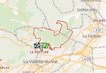
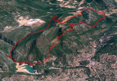
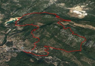
Trail Walking of 19.8 km to be discovered at Provence-Alpes-Côte d'Azur, Var, La Valette-du-Var. This trail is proposed by Christiancordin.
Description
Départ PK jardin remarquable de Baudouvin-vallon de la Sorbière-
fort du Baou pointu- le Coudon--le petit Coudon-oratoire-vallon de la Giraude-le canal enterré-table d'orientation- la Brémone-Pk.
Positioning
Country:
France
Region :
Provence-Alpes-Côte d'Azur
Department/Province :
Var
Municipality :
La Valette-du-Var
Location:
Unknown
Start:(Dec)
Start:(UTM)
742703 ; 4781333 (31T) N.
Comments
Trails nearby
![Trail Walking Le Revest-les-Eaux - Boucle: La ripelle - Source de la ripelle - Le Chateau de Tourris - Les grottes de sable - La carrière aux fourmis - Les puits renovés de M. Lambicchi - Les ruines des Olivières - La ferme de la Touravelle - à Le Revest-les-Eaux - Photo](https://media.geolcdn.com/t/375/260/0dbff04b-2a84-4eed-a6e8-7a56bc074382.jpg&format=jpg&maxdim=2)
![Walking Walking](https://static1.geolcdn.com/sitytour/trail-icons/101.png)
Boucle: La ripelle - Source de la ripelle - Le Chateau de Tourris - Les grott...
Walking
Medium
(1)
Le Revest-les-Eaux,
Provence-Alpes-Côte d'Azur,
Var,
France
![](/images/other/stat-length.png)
14.1 km | 21 km-effort
4h 15min
![](https://static1.geolcdn.com/siteimages/upload/files/16400158638029165_repeat_loop_refresh_sync_direction_icon.png)
Yes
![Trail Walking Toulon - Faron versant Nord - Photo](https://media.geolcdn.com/t/375/260/40a1f88d-10a7-4595-84a1-0086eecb7f84.jpg&format=jpg&maxdim=2)
![Walking Walking](https://static1.geolcdn.com/sitytour/trail-icons/101.png)
Faron versant Nord
Walking
Very difficult
(1)
Toulon,
Provence-Alpes-Côte d'Azur,
Var,
France
![](/images/other/stat-length.png)
9.9 km | 17.5 km-effort
6h 38min
![](https://static1.geolcdn.com/siteimages/upload/files/16400158638029165_repeat_loop_refresh_sync_direction_icon.png)
Yes
![Trail Walking Le Revest-les-Eaux - 83 barrage revest les eaux 24-05-2021 - Photo](https://media.geolcdn.com/t/375/260/1106c6f7-fedf-4077-96a1-b48580038b53.jpg&format=jpg&maxdim=2)
![Walking Walking](https://static1.geolcdn.com/sitytour/trail-icons/101.png)
83 barrage revest les eaux 24-05-2021
Walking
Medium
(1)
Le Revest-les-Eaux,
Provence-Alpes-Côte d'Azur,
Var,
France
![](/images/other/stat-length.png)
8 km | 12.3 km-effort
3h 41min
![](https://static1.geolcdn.com/siteimages/upload/files/16400158638029165_repeat_loop_refresh_sync_direction_icon.png)
Yes
![Trail Walking La Valette-du-Var - SityTrail - Le tour du coudon - Photo](https://media.geolcdn.com/t/375/260/c1a593ce-5178-4a51-a2b4-9401a3556db4.jpg&format=jpg&maxdim=2)
![Walking Walking](https://static1.geolcdn.com/sitytour/trail-icons/101.png)
SityTrail - Le tour du coudon
Walking
Difficult
(1)
La Valette-du-Var,
Provence-Alpes-Côte d'Azur,
Var,
France
![](/images/other/stat-length.png)
11.9 km | 19.4 km-effort
5h 0min
![](https://static1.geolcdn.com/siteimages/upload/files/16400158638029165_repeat_loop_refresh_sync_direction_icon.png)
Yes
![Trail Walking Le Revest-les-Eaux - Boucle: Ripelle - Touravelle - Ruines des olivieres - Carrière aux fourmis - Grottes de sables - Vieille valette - Tourris - Source - Ripelle - Photo](https://media.geolcdn.com/t/375/260/ext.jpg?maxdim=2&url=https%3A%2F%2Fstatic1.geolcdn.com%2Fsiteimages%2Fupload%2Ffiles%2F1553511878bg_sport_marche.png)
![Walking Walking](https://static1.geolcdn.com/sitytour/trail-icons/101.png)
Boucle: Ripelle - Touravelle - Ruines des olivieres - Carrière aux fourmis ...
Walking
Medium
(1)
Le Revest-les-Eaux,
Provence-Alpes-Côte d'Azur,
Var,
France
![](/images/other/stat-length.png)
13.4 km | 19.4 km-effort
5h 0min
![](https://static1.geolcdn.com/siteimages/upload/files/16400158638029165_repeat_loop_refresh_sync_direction_icon.png)
Yes
![Trail Walking La Valette-du-Var - SityTrail - Le Revest - Tourris - Confinement 04 2021 - Photo](https://media.geolcdn.com/t/375/260/79fe425d-11d9-4d0f-acb5-646a4a616c9e.jpg&format=jpg&maxdim=2)
![Walking Walking](https://static1.geolcdn.com/sitytour/trail-icons/101.png)
SityTrail - Le Revest - Tourris - Confinement 04 2021
Walking
Easy
La Valette-du-Var,
Provence-Alpes-Côte d'Azur,
Var,
France
![](/images/other/stat-length.png)
11.8 km | 18.8 km-effort
7h 0min
![](https://static1.geolcdn.com/siteimages/upload/files/16400158638029165_repeat_loop_refresh_sync_direction_icon.png)
Yes
![Trail Walking Toulon - Tour royale à Monaco 13 Novembre 2021 - Photo](https://media.geolcdn.com/t/375/260/d44cd298-c3f2-4c69-9481-e73635990ceb.jpg&format=jpg&maxdim=2)
![Walking Walking](https://static1.geolcdn.com/sitytour/trail-icons/101.png)
Tour royale à Monaco 13 Novembre 2021
Walking
Easy
Toulon,
Provence-Alpes-Côte d'Azur,
Var,
France
![](/images/other/stat-length.png)
15.6 km | 19.8 km-effort
5h 49min
![](https://static1.geolcdn.com/siteimages/upload/files/16400158638029165_repeat_loop_refresh_sync_direction_icon.png)
No
![Trail Walking La Valette-du-Var - Le Revest - Tourris - Confinement 04 2021 - Photo](https://media.geolcdn.com/t/375/260/ed75aaac-3d73-40cf-a26a-b9d52cf8e68b.jpg&format=jpg&maxdim=2)
![Walking Walking](https://static1.geolcdn.com/sitytour/trail-icons/101.png)
Le Revest - Tourris - Confinement 04 2021
Walking
Medium
La Valette-du-Var,
Provence-Alpes-Côte d'Azur,
Var,
France
![](/images/other/stat-length.png)
12.1 km | 19.1 km-effort
6h 0min
![](https://static1.geolcdn.com/siteimages/upload/files/16400158638029165_repeat_loop_refresh_sync_direction_icon.png)
Yes
![Trail Walking Le Revest-les-Eaux - Boucle découverte Ripelle - Mont Combe - Olivières - Ragas - Barrage - Touravelle - Ripelle - Photo](https://media.geolcdn.com/t/375/260/eba2448f-1107-4c3b-8b78-b71d56320542.jpg&format=jpg&maxdim=2)
![Walking Walking](https://static1.geolcdn.com/sitytour/trail-icons/101.png)
Boucle découverte Ripelle - Mont Combe - Olivières - Ragas - Barrage - Tourav...
Walking
Medium
Le Revest-les-Eaux,
Provence-Alpes-Côte d'Azur,
Var,
France
![](/images/other/stat-length.png)
9.7 km | 15.8 km-effort
5h 0min
![](https://static1.geolcdn.com/siteimages/upload/files/16400158638029165_repeat_loop_refresh_sync_direction_icon.png)
Yes