Trail Walking Unknown - Walk1 - Photo
© OpenStreetMap contributors
Length
Length
109 m
Max alt
Max alt
171 m
Uphill gradient
Uphill gradient
0 m
Km-Effort
Km-Effort  
109 m
Min alt
Min alt
168 m
Downhill gradient
Downhill gradient
0 m
Boucle
Boucle
No
Creation date :
2023-03-05 16:44:22.0
Updated on :
2023-03-05 16:47:26.547

(0 Reviews)

Walking
Walking
2m
Difficulty : Easy

Scan this QR Code to open this trail in the SityTrail application

FREE GPS app for hiking

Logo SityTrail SityTrail

IGN / Geographical institutes

Download SityTrail from the App Store Download SityTrail from Google Play

Logo SityTrail SityTrail World

The world is yours!

Download SityTrail from the App Store Download SityTrail from Google Play Download SityTrail on Huawei AppGallery

About

Trail Walking of 109 m to be discovered at Maryland, Baltimore County. This trail is proposed by jason reinhardt.

Description

Test 2

Elevation profile

Positioning

Country:
United States
Region :
Maryland
Department/Province :
Baltimore County
Municipality :
Unknown
Location:
Unknown
Start:(UTM)
359933 ; 4371936 (18S) N.

Trails nearby

Trail Trail  - Trail1 - Photo
Trail
jason reinhardt

Trail

, Maryland, Baltimore County, United States
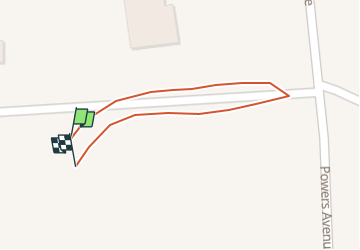
3.1 km | 4.1 km-effort
1h 6min
No
Trail Walking  - Trail 2 - Photo
Walking
jason reinhardt

Walking

Easy
, Maryland, Baltimore County, United States
10 m | 0 m-effort
38min
No
Trail Walking  - Home  - Photo
Walking
jason reinhardt

Walking

Easy
, Maryland, Baltimore County, United States
17 m | 0 m-effort
5min
No


Close
My subscriptions