Trail Walking Nailhac - Boucle de Nailhac  - Photo

Boucle de Nailhac

 swp648
swp648

User

© OpenStreetMap contributors
Length
Length
11.7 km
Max alt
Max alt
321 m
Uphill gradient
Uphill gradient
244 m
Km-Effort
Km-Effort  
14.9 km
Min alt
Min alt
196 m
Downhill gradient
Downhill gradient
243 m
Boucle
Boucle
Yes
Creation date :
2023-03-05 07:59:12.947
Updated on :
2023-03-05 11:42:29.099

(0 Reviews)

Walking
Walking
2h54
Difficulty : Easy

Scan this QR Code to open this trail in the SityTrail application

FREE GPS app for hiking

Logo SityTrail SityTrail

IGN / Geographical institutes

Download SityTrail from the App Store Download SityTrail from Google Play

Logo SityTrail SityTrail World

The world is yours!

Download SityTrail from the App Store Download SityTrail from Google Play Download SityTrail on Huawei AppGallery

About

Trail Walking of 11.7 km to be discovered at New Aquitaine, Dordogne, Nailhac. This trail is proposed by swp648.

Description

Une très belle randonnée avec des panoramas à 380°, belles bâtisses, de magnifiques plantations de noyer, vues sur le château d'Hautefort.

Elevation profile

Photos

Positioning

Country:
France
Region :
New Aquitaine
Department/Province :
Dordogne
Municipality :
Nailhac
Location:
Unknown
Start:(UTM)
355037 ; 5009803 (31T) N.

Trails nearby

Trail Walking Granges-d'Ans - Paysage et nature depuis Granges-d’Ans - Photo
Walking
houbart

Walking

Difficult
Granges-d'Ans, New Aquitaine, Dordogne, France
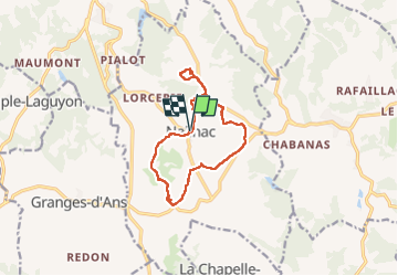
11.8 km | 15 km-effort
3h 24min
Yes
Trail Mountain bike La Chapelle-Saint-Jean - La Chapelle Saint Jean - Photo
Mountain bike
heyoka

Mountain bike

Easy
La Chapelle-Saint-Jean, New Aquitaine, Dordogne, France
11.7 km | 14.7 km-effort
3h 20min
No
Trail Mountain bike La Chapelle-Saint-Jean - 2 - Photo
Mountain bike
christophe binet

Mountain bike

Very difficult
La Chapelle-Saint-Jean, New Aquitaine, Dordogne, France
41 km | 52 km-effort
1h 47min
No
Trail Walking Châtres - boucle chatres - Photo
Walking
fab0202

Walking

Easy
(1)
Châtres, New Aquitaine, Dordogne, France
10.9 km | 14.7 km-effort
2h 42min
Yes
Trail On foot Nailhac - Nailhac Noix allongée 11km - Photo
On foot
YV24

On foot

Easy
(2)
Nailhac, New Aquitaine, Dordogne, France
11.1 km | 14.2 km-effort
Unknown
Yes
Trail Walking Saint-Rabier - chateau coderc - Photo
Walking
personono

Walking

Easy
Saint-Rabier, New Aquitaine, Dordogne, France
7.1 km | 9 km-effort
1h 52min
Yes
Trail Walking Nailhac - Chassaignas La Chapelle St Jean 12km - Photo
Walking
YV24

Walking

Easy
Nailhac, New Aquitaine, Dordogne, France
11.9 km | 15.2 km-effort
3h 16min
Yes
Trail Walking Saint-Rabier - Gd Coderc Grange d'Ans 12 km - Photo
Walking
YV24

Walking

Easy
Saint-Rabier, New Aquitaine, Dordogne, France
11.7 km | 15.5 km-effort
3h 18min
Yes
Trail Walking Hautefort - HAUTEFORT Milpas court - Photo
Walking
pascalmilpas

Walking

Difficult
Hautefort, New Aquitaine, Dordogne, France
10 km | 12.9 km-effort
2h 29min
Yes


Close
My subscriptions