![](/images/other/stat-length.png)
![Trail Walking Brie-Comte-Robert - ADXBCR12.5Ptitval - Photo](https://media.geolcdn.com/t/1900/400/ext.pjpeg?maxdim=2&url=https%3A%2F%2Fstatic1.geolcdn.com%2Fsiteimages%2Fupload%2Ffiles%2F1553511878bg_sport_marche.png)
ADXBCR12.5Ptitval
Ben Ayed Catherine
User
![Length](/images/other/stat-length.png)
Length
12.7 km
![Max alt](https://static1.geolcdn.com/siteimages/upload/files/1508320355ic_sort_altitude_max_24dp.png)
Max alt
101 m
![Uphill gradient](https://static1.geolcdn.com/siteimages/upload/files/1508320355ic_sort_den_pos_24dp.png)
Uphill gradient
97 m
![Km-Effort](/images/other/stat-length.png)
Km-Effort
14 km
![Min alt](https://static1.geolcdn.com/siteimages/upload/files/1508320355ic_sort_altitude_min_24dp.png)
Min alt
59 m
![Downhill gradient](https://static1.geolcdn.com/siteimages/upload/files/1508320355ic_sort_den_neg_24dp.png)
Downhill gradient
93 m
![Boucle](https://static1.geolcdn.com/siteimages/upload/files/16400158638029165_repeat_loop_refresh_sync_direction_icon.png)
Boucle
No
Creation date :
2023-03-05 07:31:12.0
Updated on :
2023-03-05 10:48:51.253
![Walking](https://static1.geolcdn.com/sitytour/trail-icons/101.png)
2h10
Difficulty : Difficult
![Scan this QR Code to open this trail in the SityTrail application](https://capi.geolives.com/qq0zvz2zws4bq2lad0pu/sitytour/trails/3573890/qr.png?size=200)
FREE GPS app for hiking
About
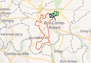
Trail Walking of 12.7 km to be discovered at Ile-de-France, Seine-et-Marne, Brie-Comte-Robert. This trail is proposed by Ben Ayed Catherine.
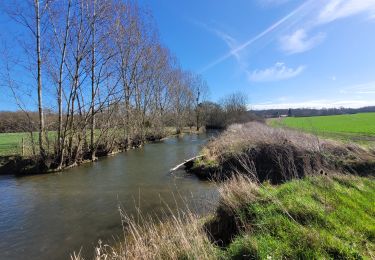
Description
Passage gue Bourdon
Passage ss lep ont de la Francilienne
Retour parc Mitterand. et chemin des roses
à faire par temps sec
Positioning
Country:
France
Region :
Ile-de-France
Department/Province :
Seine-et-Marne
Municipality :
Brie-Comte-Robert
Location:
Unknown
Start:(Dec)
Start:(UTM)
471602 ; 5393702 (31U) N.
Comments
Trails nearby
![Trail Walking Servon - J 22 12.00 km Lésigny intempéries - Photo](https://media.geolcdn.com/t/375/260/ext.jpg?maxdim=2&url=https%3A%2F%2Fstatic1.geolcdn.com%2Fsiteimages%2Fupload%2Ffiles%2F1553511878bg_sport_marche.png)
![Walking Walking](https://static1.geolcdn.com/sitytour/trail-icons/101.png)
J 22 12.00 km Lésigny intempéries
Walking
Medium
(5)
Servon,
Ile-de-France,
Seine-et-Marne,
France
![](/images/other/stat-length.png)
12.6 km | 14.2 km-effort
3h 10min
![](https://static1.geolcdn.com/siteimages/upload/files/16400158638029165_repeat_loop_refresh_sync_direction_icon.png)
Yes
![Trail On foot Servon - nom_fic (49) - Photo](https://media.geolcdn.com/t/375/260/b5894e46-d1cd-485b-a28c-446d5e91d239.jpg&format=jpg&maxdim=2)
![On foot On foot](https://static1.geolcdn.com/sitytour/trail-icons/100.png)
nom_fic (49)
On foot
Very easy
(6)
Servon,
Ile-de-France,
Seine-et-Marne,
France
![](/images/other/stat-length.png)
6.6 km | 7.6 km-effort
1h 43min
![](https://static1.geolcdn.com/siteimages/upload/files/16400158638029165_repeat_loop_refresh_sync_direction_icon.png)
Yes
![Trail Walking Marolles-en-Brie - GRP CV-IDF 05 - Photo](https://media.geolcdn.com/t/375/260/3f1bdad2-a959-4f32-b201-59b2c8841688.jpg&format=jpg&maxdim=2)
![Walking Walking](https://static1.geolcdn.com/sitytour/trail-icons/101.png)
GRP CV-IDF 05
Walking
Difficult
(1)
Marolles-en-Brie,
Ile-de-France,
Val-de-Marne,
France
![](/images/other/stat-length.png)
13.5 km | 15.2 km-effort
3h 27min
![](https://static1.geolcdn.com/siteimages/upload/files/16400158638029165_repeat_loop_refresh_sync_direction_icon.png)
No
![On foot On foot](https://static1.geolcdn.com/sitytour/trail-icons/100.png)
J 01 11.97 km les 5 châteaux
On foot
Easy
(3)
Servon,
Ile-de-France,
Seine-et-Marne,
France
![](/images/other/stat-length.png)
11.3 km | 12.7 km-effort
2h 53min
![](https://static1.geolcdn.com/siteimages/upload/files/16400158638029165_repeat_loop_refresh_sync_direction_icon.png)
Yes
![Trail On foot Servon - R 04 - 8 km - Servon, Santeny, Servon - Photo](https://media.geolcdn.com/t/375/260/b334c7b2-5ac3-4f3d-879c-3237cd85e14e.jpg&format=jpg&maxdim=2)
![On foot On foot](https://static1.geolcdn.com/sitytour/trail-icons/100.png)
R 04 - 8 km - Servon, Santeny, Servon
On foot
Very difficult
(5)
Servon,
Ile-de-France,
Seine-et-Marne,
France
![](/images/other/stat-length.png)
7.9 km | 9.1 km-effort
2h 3min
![](https://static1.geolcdn.com/siteimages/upload/files/16400158638029165_repeat_loop_refresh_sync_direction_icon.png)
Yes
![Trail Walking Brie-Comte-Robert - brie comte robert - Photo](https://media.geolcdn.com/t/375/260/ext.jpg?maxdim=2&url=https%3A%2F%2Fservices.sitytrail.com%2FGeolivesWS%2FDownloadMedia.ashx%3FTrailID%3D172162%26Media%3D20130130123759.jpeg)
![Walking Walking](https://static1.geolcdn.com/sitytour/trail-icons/101.png)
brie comte robert
Walking
Easy
(2)
Brie-Comte-Robert,
Ile-de-France,
Seine-et-Marne,
France
![](/images/other/stat-length.png)
16.7 km | 18.8 km-effort
4h 21min
![](https://static1.geolcdn.com/siteimages/upload/files/16400158638029165_repeat_loop_refresh_sync_direction_icon.png)
Yes
![Trail Walking Évry-Grégy-sur-Yerre - J 55 miguelmillepattes Evry Grégy sur Yerres - Prieuré de Vernelle - Photo](https://media.geolcdn.com/t/375/260/838bff98-2775-4bd0-83b3-89163c602221.jpg&format=jpg&maxdim=2)
![Walking Walking](https://static1.geolcdn.com/sitytour/trail-icons/101.png)
J 55 miguelmillepattes Evry Grégy sur Yerres - Prieuré de Vernelle
Walking
Medium
(2)
Évry-Grégy-sur-Yerre,
Ile-de-France,
Seine-et-Marne,
France
![](/images/other/stat-length.png)
11.9 km | 13.6 km-effort
3h 5min
![](https://static1.geolcdn.com/siteimages/upload/files/16400158638029165_repeat_loop_refresh_sync_direction_icon.png)
Yes
![Trail Walking Servon - JC 24 Servon , Villecresnes, forêt de la Grange - Photo](https://media.geolcdn.com/t/375/260/9e243d85-e3cc-498b-9c48-b6dc55815f83.jpg&format=jpg&maxdim=2)
![Walking Walking](https://static1.geolcdn.com/sitytour/trail-icons/101.png)
JC 24 Servon , Villecresnes, forêt de la Grange
Walking
Difficult
(3)
Servon,
Ile-de-France,
Seine-et-Marne,
France
![](/images/other/stat-length.png)
20 km | 22 km-effort
5h 6min
![](https://static1.geolcdn.com/siteimages/upload/files/16400158638029165_repeat_loop_refresh_sync_direction_icon.png)
Yes
![Trail On foot Servon - R 09 8.0 km km santeny - l'Orée de Lesigny - Photo](https://media.geolcdn.com/t/375/260/11d95486-f82b-4ca7-8b67-f8a9760634b1.jpg&format=jpg&maxdim=2)
![On foot On foot](https://static1.geolcdn.com/sitytour/trail-icons/100.png)
R 09 8.0 km km santeny - l'Orée de Lesigny
On foot
Easy
(1)
Servon,
Ile-de-France,
Seine-et-Marne,
France
![](/images/other/stat-length.png)
8 km | 9.2 km-effort
2h 5min
![](https://static1.geolcdn.com/siteimages/upload/files/16400158638029165_repeat_loop_refresh_sync_direction_icon.png)
Yes