![](/images/other/stat-length.png)
![Trail Walking Gex - JURA 2023 J4 projet - Col de la Faucille à Saint Cergue 18 770mm +700m - Photo](https://media.geolcdn.com/t/1900/400/ext.pjpeg?maxdim=2&url=https%3A%2F%2Fstatic1.geolcdn.com%2Fsiteimages%2Fupload%2Ffiles%2F1553511878bg_sport_marche.png)
JURA 2023 J4 projet - Col de la Faucille à Saint Cergue 18 770mm +700m
DanielROLLET
User
![Length](/images/other/stat-length.png)
Length
18.8 km
![Max alt](https://static1.geolcdn.com/siteimages/upload/files/1508320355ic_sort_altitude_max_24dp.png)
Max alt
1669 m
![Uphill gradient](https://static1.geolcdn.com/siteimages/upload/files/1508320355ic_sort_den_pos_24dp.png)
Uphill gradient
700 m
![Km-Effort](/images/other/stat-length.png)
Km-Effort
29 km
![Min alt](https://static1.geolcdn.com/siteimages/upload/files/1508320355ic_sort_altitude_min_24dp.png)
Min alt
1043 m
![Downhill gradient](https://static1.geolcdn.com/siteimages/upload/files/1508320355ic_sort_den_neg_24dp.png)
Downhill gradient
983 m
![Boucle](https://static1.geolcdn.com/siteimages/upload/files/16400158638029165_repeat_loop_refresh_sync_direction_icon.png)
Boucle
No
Creation date :
2023-03-02 15:27:36.458
Updated on :
2023-05-10 08:40:33.23
![Walking](https://static1.geolcdn.com/sitytour/trail-icons/101.png)
6h36
Difficulty : Very difficult
![Scan this QR Code to open this trail in the SityTrail application](https://capi.geolives.com/qq0zvz2zws4bq2lad0pu/sitytour/trails/3570733/qr.png?size=200)
FREE GPS app for hiking
About
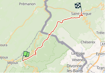
Trail Walking of 18.8 km to be discovered at Auvergne-Rhône-Alpes, Ain, Gex. This trail is proposed by DanielROLLET.
Description
Raccourci possible pour passer à la Vattay et par le circuit de l'Archette à Saint-Cergue.
Circuit abandonné cause fermeture hébergements au Col de la Faucille le 6/7 mai
Positioning
Country:
France
Region :
Auvergne-Rhône-Alpes
Department/Province :
Ain
Municipality :
Gex
Location:
Unknown
Start:(Dec)
Start:(UTM)
270704 ; 5139447 (32T) N.
Comments
Trails nearby
![Trail Walking Lamoura - Tresberruy - Lamoura - Photo](https://media.geolcdn.com/t/375/260/ext.jpg?maxdim=2&url=https%3A%2F%2Fservices.sitytrail.com%2FGeolivesWS%2FDownloadMedia.ashx%3FTrailID%3D191503%26Media%3D15097_5.jpg)
![Walking Walking](https://static1.geolcdn.com/sitytour/trail-icons/101.png)
Tresberruy - Lamoura
Walking
Difficult
(1)
Lamoura,
Bourgogne-Franche-Comté,
Jura,
France
![](/images/other/stat-length.png)
14.5 km | 20 km-effort
4h 0min
![](https://static1.geolcdn.com/siteimages/upload/files/16400158638029165_repeat_loop_refresh_sync_direction_icon.png)
Yes
![Trail Cycle Lajoux - 2023-08-18_15h23m20_lamoura - Photo](https://media.geolcdn.com/t/375/260/ext.jpg?maxdim=2&url=https%3A%2F%2Fstatic1.geolcdn.com%2Fsiteimages%2Fupload%2Ffiles%2F1524743154velo.jpg)
![Cycle Cycle](https://static1.geolcdn.com/sitytour/trail-icons/200.png)
2023-08-18_15h23m20_lamoura
Cycle
Very easy
(1)
Lajoux,
Bourgogne-Franche-Comté,
Jura,
France
![](/images/other/stat-length.png)
21 km | 26 km-effort
Unknown
![](https://static1.geolcdn.com/siteimages/upload/files/16400158638029165_repeat_loop_refresh_sync_direction_icon.png)
Yes
![Trail Running Mijoux - UTTJ 2015-2 - Photo](https://media.geolcdn.com/t/375/260/ext.jpg?maxdim=2&url=https%3A%2F%2Fstatic1.geolcdn.com%2Fsiteimages%2Fupload%2Ffiles%2F1524743154running.jpg)
![Running Running](https://static1.geolcdn.com/sitytour/trail-icons/103.png)
UTTJ 2015-2
Running
Very difficult
(1)
Mijoux,
Auvergne-Rhône-Alpes,
Ain,
France
![](/images/other/stat-length.png)
57 km | 92 km-effort
18h 13min
![](https://static1.geolcdn.com/siteimages/upload/files/16400158638029165_repeat_loop_refresh_sync_direction_icon.png)
No
![Trail Walking Lamoura - lamoura neige et plein air - Photo](https://media.geolcdn.com/t/375/260/79eb4e53-0429-41e7-9bcb-cf15e9d8ead1.jpg&format=jpg&maxdim=2)
![Walking Walking](https://static1.geolcdn.com/sitytour/trail-icons/101.png)
lamoura neige et plein air
Walking
Difficult
Lamoura,
Bourgogne-Franche-Comté,
Jura,
France
![](/images/other/stat-length.png)
6.8 km | 9.5 km-effort
2h 25min
![](https://static1.geolcdn.com/siteimages/upload/files/16400158638029165_repeat_loop_refresh_sync_direction_icon.png)
Yes
![Trail Walking Lamoura - neige et plein air lamoura - Photo](https://media.geolcdn.com/t/375/260/0b5e943d-bb9b-41cd-9490-d26e61edcd49.jpg&format=jpg&maxdim=2)
![Walking Walking](https://static1.geolcdn.com/sitytour/trail-icons/101.png)
neige et plein air lamoura
Walking
Medium
Lamoura,
Bourgogne-Franche-Comté,
Jura,
France
![](/images/other/stat-length.png)
6.8 km | 9.3 km-effort
2h 54min
![](https://static1.geolcdn.com/siteimages/upload/files/16400158638029165_repeat_loop_refresh_sync_direction_icon.png)
Yes
![Trail Walking Lajoux - Le crêt de la vigoureuse (le vrai) - Photo](https://media.geolcdn.com/t/375/260/5ee095a6-7dfc-4756-a886-0e730cf92336.jpg&format=jpg&maxdim=2)
![Walking Walking](https://static1.geolcdn.com/sitytour/trail-icons/101.png)
Le crêt de la vigoureuse (le vrai)
Walking
Easy
Lajoux,
Bourgogne-Franche-Comté,
Jura,
France
![](/images/other/stat-length.png)
10.4 km | 13.4 km-effort
4h 9min
![](https://static1.geolcdn.com/siteimages/upload/files/16400158638029165_repeat_loop_refresh_sync_direction_icon.png)
Yes
![Trail Walking Lajoux - crêt vigoureuse - Photo](https://media.geolcdn.com/t/375/260/621ceada-b70a-4736-ab71-b2ed77e63872.jpg&format=jpg&maxdim=2)
![Walking Walking](https://static1.geolcdn.com/sitytour/trail-icons/101.png)
crêt vigoureuse
Walking
Medium
Lajoux,
Bourgogne-Franche-Comté,
Jura,
France
![](/images/other/stat-length.png)
12.3 km | 16.8 km-effort
5h 0min
![](https://static1.geolcdn.com/siteimages/upload/files/16400158638029165_repeat_loop_refresh_sync_direction_icon.png)
Yes
![Trail Walking Gex - Balade à Col de la Faucille, Gex - Photo](https://media.geolcdn.com/t/375/260/2f44fa08-e5b7-4e3a-aeb8-a26203de0478.jpg&format=jpg&maxdim=2)
![Walking Walking](https://static1.geolcdn.com/sitytour/trail-icons/101.png)
Balade à Col de la Faucille, Gex
Walking
Very difficult
Gex,
Auvergne-Rhône-Alpes,
Ain,
France
![](/images/other/stat-length.png)
86 km | 135 km-effort
9h 23min
![](https://static1.geolcdn.com/siteimages/upload/files/16400158638029165_repeat_loop_refresh_sync_direction_icon.png)
No
![Trail Bicycle tourism Mijoux - LES ROUSSES - COL DE LA FAUCILLE - Photo](https://media.geolcdn.com/t/375/260/8bcbda14-9a90-4870-91bc-b4b02ae26659.jpg&format=jpg&maxdim=2)
![Bicycle tourism Bicycle tourism](https://static1.geolcdn.com/sitytour/trail-icons/204.png)
LES ROUSSES - COL DE LA FAUCILLE
Bicycle tourism
Very difficult
Mijoux,
Auvergne-Rhône-Alpes,
Ain,
France
![](/images/other/stat-length.png)
54 km | 68 km-effort
4h 57min
![](https://static1.geolcdn.com/siteimages/upload/files/16400158638029165_repeat_loop_refresh_sync_direction_icon.png)
No