Trail Walking Sare - ibanteli - Photo
 poluxoff
poluxoff

User

© OpenStreetMap contributors
Length
Length
14.2 km
Max alt
Max alt
652 m
Uphill gradient
Uphill gradient
677 m
Km-Effort
Km-Effort  
23 km
Min alt
Min alt
103 m
Downhill gradient
Downhill gradient
676 m
Boucle
Boucle
Yes
Creation date :
2014-12-10 00:00:00.0
Updated on :
2014-12-10 00:00:00.0

(0 Reviews)

Walking
Walking
--
Difficulty : Easy

Scan this QR Code to open this trail in the SityTrail application

FREE GPS app for hiking

Logo SityTrail SityTrail

IGN / Geographical institutes

Download SityTrail from the App Store Download SityTrail from Google Play

Logo SityTrail SityTrail World

The world is yours!

Download SityTrail from the App Store Download SityTrail from Google Play Download SityTrail on Huawei AppGallery

About

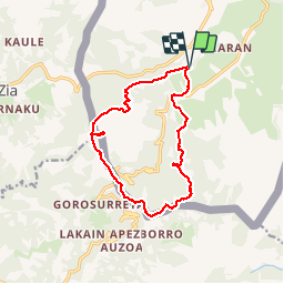
Trail Walking of 14.2 km to be discovered at New Aquitaine, Pyrénées-Atlantiques, Sare. This trail is proposed by poluxoff.

Description

De Sare prendre la direction du restaurant pikassaria puis la petite route en face sur 3 km jusqu'à une borne surmontée d'une croix en fer Un autre chemin de Randonnée qui nous a fait découvrir les palombiéres de Sare avant de poursuivre sur le Gr 11 en direction de l'ibanteli.Superbes vues.

Elevation profile

Positioning

Country:
France
Region :
New Aquitaine
Department/Province :
Pyrénées-Atlantiques
Municipality :
Sare
Location:
Unknown
Start:(UTM)
613935 ; 4793507 (30T) N.

Trails nearby

Trail Walking Sare - sare - Photo
Walking
JPLACANAU

Walking

Very easy
(1)
Sare, New Aquitaine, Pyrénées-Atlantiques, France
6.6 km | 8.9 km-effort
2h 22min
No
Trail Walking Saint-Pée-sur-Nivelle - Cherchebruit pinodieta ainhoa  - Photo
Walking
GUIDE
antignacs

Walking

Easy
Saint-Pée-sur-Nivelle, New Aquitaine, Pyrénées-Atlantiques, France
19.3 km | 27 km-effort
5h 59min
Yes
Trail Walking Sare - La rhune par la face EST - Photo
Walking
DECHAMPD

Walking

Medium
(1)
Sare, New Aquitaine, Pyrénées-Atlantiques, France
13.8 km | 26 km-effort
5h 10min
Yes
Trail Walking Sare - sare les palombieres - Photo
Walking
GUIDE
antignacs

Walking

Easy
Sare, New Aquitaine, Pyrénées-Atlantiques, France
15.8 km | 24 km-effort
4h 44min
Yes
Trail Walking Sare - la rhune depuis Sare (2) - Photo
Walking
jcaudron

Walking

Very easy
(4)
Sare, New Aquitaine, Pyrénées-Atlantiques, France
13.9 km | 26 km-effort
4h 0min
Yes
Trail Walking Sare - atxuria zugaramurdi - Photo
Walking
jcaudron

Walking

Very easy
(3)
Sare, New Aquitaine, Pyrénées-Atlantiques, France
10.3 km | 18.7 km-effort
3h 50min
Yes
Trail Walking Sare - col de lizarrieta et col des 3 bornes - Photo
Walking
henribatut

Walking

Difficult
Sare, New Aquitaine, Pyrénées-Atlantiques, France
13 km | 18.5 km-effort
3h 45min
Yes
Trail Walking Sare - Lizarrieta,  Zentinel, col des 3 bornes,  2024 03 04. - Photo
Walking
DECHAMPD

Walking

Difficult
Sare, New Aquitaine, Pyrénées-Atlantiques, France
12.4 km | 17.8 km-effort
4h 3min
Yes
Trail Walking Sare - Boucle autour de Sare - Photo
Walking
CooolGeorges

Walking

Difficult
Sare, New Aquitaine, Pyrénées-Atlantiques, France
10.7 km | 15.1 km-effort
3h 26min
Yes


Close
My subscriptions