Trail Touring skiing Le Monêtier-les-Bains - tête de pradieu  - Photo
 tchoua
tchoua

User

© OpenStreetMap contributors
Length
Length
18.3 km
Max alt
Max alt
2859 m
Uphill gradient
Uphill gradient
1343 m
Km-Effort
Km-Effort  
36 km
Min alt
Min alt
1510 m
Downhill gradient
Downhill gradient
1333 m
Boucle
Boucle
Yes
Creation date :
2023-02-25 06:06:29.208
Updated on :
2023-02-26 16:18:05.534

(0 Reviews)

Touring skiing
Touring skiing
4h03
Difficulty : Difficult

Scan this QR Code to open this trail in the SityTrail application

FREE GPS app for hiking

Logo SityTrail SityTrail

IGN / Geographical institutes

Download SityTrail from the App Store Download SityTrail from Google Play

Logo SityTrail SityTrail World

The world is yours!

Download SityTrail from the App Store Download SityTrail from Google Play Download SityTrail on Huawei AppGallery

About

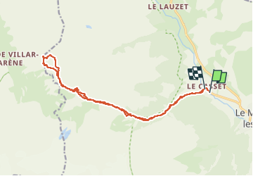
Trail Touring skiing of 18.3 km to be discovered at Provence-Alpes-Côte d'Azur, Hautes-Alpes, Le Monêtier-les-Bains. This trail is proposed by tchoua.

Description

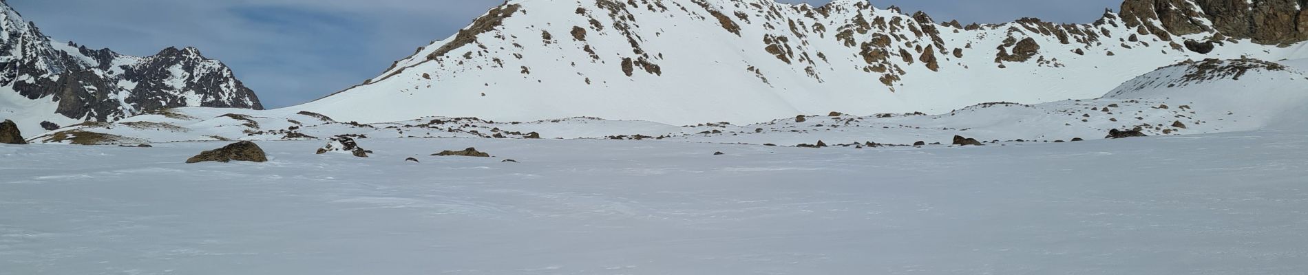
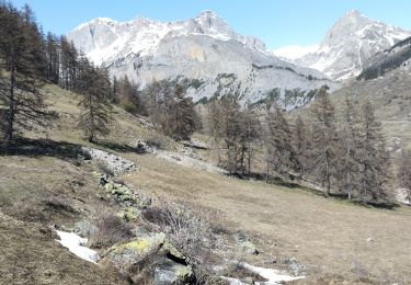
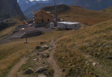
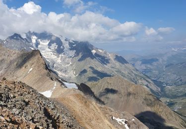
Jolie randonnée à faire soit à ski,soit à pied,depuis le village du Casset,remonter le petit tabuc jusqu’au col d arsine au fond à la cabane de berger remonter les pentes sur la droite , au dessus cela forme un petit plateau avec des dépressions c est pradieu un énorme cairn en pierre le balise on domine le cirque du glacier d arsine , calotte des agneaux,neige cordier,chamoissiere, continuer tout droit en serrant les pentes à droite on arrive à un collet qui débouche sur un cirque face nord du pic du lacs du combeynot, et face ouest du combeynot ouest en face on voit la tête de pradieu sommet  isolé qui domine là romanche et Villar-d’Arêne,traverser le cirque  beaucoup de moraines puis se diriger vers l arête par la gauche ( c est moins raide) et monter au sommet , joli panorama sur roche faurio,brèche de tombe murée, col et glacier du clos des cavales.

Elevation profile

Photos

Positioning

Country:
France
Region :
Provence-Alpes-Côte d'Azur
Department/Province :
Hautes-Alpes
Municipality :
Le Monêtier-les-Bains
Location:
Unknown
Start:(UTM)
301662 ; 4984373 (32T) N.

Trails nearby

Trail Walking Le Monêtier-les-Bains - Le Grand Lac - Photo
Walking
tracegps

Walking

Difficult
(2)
Le Monêtier-les-Bains, Provence-Alpes-Côte d'Azur, Hautes-Alpes, France
5.2 km | 12.8 km-effort
5h 0min
No
Trail Touring skiing Le Monêtier-les-Bains - La pointe de L'etandard - Photo
Touring skiing
GUIDE
nadd73

Touring skiing

Medium
Le Monêtier-les-Bains, Provence-Alpes-Côte d'Azur, Hautes-Alpes, France
9.4 km | 27 km-effort
4h 3min
Yes
Trail Walking Le Monêtier-les-Bains - 05 col ponsonniere - Photo
Walking
GUIDE
randodyssée

Walking

Medium
Le Monêtier-les-Bains, Provence-Alpes-Côte d'Azur, Hautes-Alpes, France
14.4 km | 27 km-effort
6h 25min
No
Trail Walking Le Monêtier-les-Bains - pic est de Combeynot - Photo
Walking
GUIDE
amiral13

Walking

Very difficult
Le Monêtier-les-Bains, Provence-Alpes-Côte d'Azur, Hautes-Alpes, France
13.3 km | 33 km-effort
6h 24min
Yes
Trail Walking Le Monêtier-les-Bains - l'aiguillette du Lauzet par le grand lac - Photo
Walking
GUIDE
amiral13

Walking

Difficult
Le Monêtier-les-Bains, Provence-Alpes-Côte d'Azur, Hautes-Alpes, France
13.8 km | 29 km-effort
8h 39min
Yes
Trail Walking Le Monêtier-les-Bains - Chalet de l'Alpe - Grand lac - Croix 15/08/18 - Photo
Walking
GUIDE
R@ph

Walking

Medium
Le Monêtier-les-Bains, Provence-Alpes-Côte d'Azur, Hautes-Alpes, France
11.7 km | 22 km-effort
4h 23min
Yes
Trail Via ferrata Le Monêtier-les-Bains - Via ferrata Aiguillette du Lauzet 30/06/18 - Photo
Via ferrata
GUIDE
R@ph

Via ferrata

Medium
Le Monêtier-les-Bains, Provence-Alpes-Côte d'Azur, Hautes-Alpes, France
9.5 km | 21 km-effort
2h 30min
Yes
Trail Walking Le Monêtier-les-Bains - Haut tour des Cerces - Photo
Walking
druilhe

Walking

Very difficult
(1)
Le Monêtier-les-Bains, Provence-Alpes-Côte d'Azur, Hautes-Alpes, France
42 km | 77 km-effort
15h 27min
Yes
Trail Walking Le Monêtier-les-Bains - Le grand lac - Photo
Walking
GUIDE
amiral13

Walking

Medium
Le Monêtier-les-Bains, Provence-Alpes-Côte d'Azur, Hautes-Alpes, France
10.7 km | 20 km-effort
6h 15min
Yes


Close
My subscriptions