![](/images/other/stat-length.png)
![Trail Walking Chambors - Chambors - Les Groux, bois de gomerfont - 8 km - Photo](https://media.geolcdn.com/t/1900/400/ext.pjpeg?maxdim=2&url=https%3A%2F%2Fstatic1.geolcdn.com%2Fsiteimages%2Fupload%2Ffiles%2F1553511878bg_sport_marche.png)
Chambors - Les Groux, bois de gomerfont - 8 km
Marie-Claire-mcp
User
![Length](/images/other/stat-length.png)
Length
8 km
![Max alt](https://static1.geolcdn.com/siteimages/upload/files/1508320355ic_sort_altitude_max_24dp.png)
Max alt
151 m
![Uphill gradient](https://static1.geolcdn.com/siteimages/upload/files/1508320355ic_sort_den_pos_24dp.png)
Uphill gradient
115 m
![Km-Effort](/images/other/stat-length.png)
Km-Effort
9.6 km
![Min alt](https://static1.geolcdn.com/siteimages/upload/files/1508320355ic_sort_altitude_min_24dp.png)
Min alt
64 m
![Downhill gradient](https://static1.geolcdn.com/siteimages/upload/files/1508320355ic_sort_den_neg_24dp.png)
Downhill gradient
115 m
![Boucle](https://static1.geolcdn.com/siteimages/upload/files/16400158638029165_repeat_loop_refresh_sync_direction_icon.png)
Boucle
Yes
Creation date :
2023-02-25 09:57:32.392
Updated on :
2023-02-25 10:01:26.614
![Walking](https://static1.geolcdn.com/sitytour/trail-icons/101.png)
2h10
Difficulty : Medium
![Scan this QR Code to open this trail in the SityTrail application](https://capi.geolives.com/qq0zvz2zws4bq2lad0pu/sitytour/trails/3564459/qr.png?size=200)
FREE GPS app for hiking
About
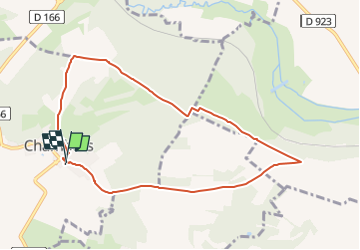
Trail Walking of 8 km to be discovered at Hauts-de-France, Oise, Chambors. This trail is proposed by Marie-Claire-mcp.
Description
Départ Parking de la salle des fêtes de Chambors puis direction les Groux, ensuite tourner à droite et continuer jusqu'au bois de gomerfont puis à droite jusqu'à Chambors
Positioning
Country:
France
Region :
Hauts-de-France
Department/Province :
Oise
Municipality :
Chambors
Location:
Unknown
Start:(Dec)
Start:(UTM)
413850 ; 5457019 (31U) N.
Comments
Trails nearby
![Trail Walking Delincourt - Delincourt, Le Mesnil, Reilly, La vierge, Delincourt - Photo](https://media.geolcdn.com/t/375/260/e0951489-e018-4b39-a4ca-54d29c362145.jpg&format=jpg&maxdim=2)
![Walking Walking](https://static1.geolcdn.com/sitytour/trail-icons/101.png)
Delincourt, Le Mesnil, Reilly, La vierge, Delincourt
Walking
Medium
(1)
Delincourt,
Hauts-de-France,
Oise,
France
![](/images/other/stat-length.png)
8.7 km | 10.4 km-effort
2h 16min
![](https://static1.geolcdn.com/siteimages/upload/files/16400158638029165_repeat_loop_refresh_sync_direction_icon.png)
Yes
![Trail Walking Vaudancourt - Vaudancourt - Breuil et Boury - Photo](https://media.geolcdn.com/t/375/260/ext.jpg?maxdim=2&url=https%3A%2F%2Fservices.sitytrail.com%2FGeolivesWS%2FDownloadMedia.ashx%3FTrailID%3D157619%26Media%3D1550d1cf-9f43-43fc-88a1-2fb31ebab517.jpg)
![Walking Walking](https://static1.geolcdn.com/sitytour/trail-icons/101.png)
Vaudancourt - Breuil et Boury
Walking
Easy
(1)
Vaudancourt,
Hauts-de-France,
Oise,
France
![](/images/other/stat-length.png)
11.8 km | 14.3 km-effort
3h 5min
![](https://static1.geolcdn.com/siteimages/upload/files/16400158638029165_repeat_loop_refresh_sync_direction_icon.png)
Yes
![Trail Walking Chambors - CHAMBORS - Lattainville-Delincourt-Reillly - Photo](https://media.geolcdn.com/t/375/260/ext.jpg?maxdim=2&url=https%3A%2F%2Fstatic1.geolcdn.com%2Fsiteimages%2Fupload%2Ffiles%2F1553511878bg_sport_marche.png)
![Walking Walking](https://static1.geolcdn.com/sitytour/trail-icons/101.png)
CHAMBORS - Lattainville-Delincourt-Reillly
Walking
Very easy
(1)
Chambors,
Hauts-de-France,
Oise,
France
![](/images/other/stat-length.png)
12.3 km | 15.2 km-effort
2h 54min
![](https://static1.geolcdn.com/siteimages/upload/files/16400158638029165_repeat_loop_refresh_sync_direction_icon.png)
Yes
![Trail Nordic walking Chambors - Marche Nordique 61 Chambors - Photo](https://media.geolcdn.com/t/375/260/ext.jpg?maxdim=2&url=https%3A%2F%2Fstatic1.geolcdn.com%2Fsiteimages%2Fupload%2Ffiles%2F1545311037marcheuse_200dpi.jpg)
![Nordic walking Nordic walking](https://static1.geolcdn.com/sitytour/trail-icons/102.png)
Marche Nordique 61 Chambors
Nordic walking
Easy
(1)
Chambors,
Hauts-de-France,
Oise,
France
![](/images/other/stat-length.png)
8.4 km | 10.3 km-effort
1h 30min
![](https://static1.geolcdn.com/siteimages/upload/files/16400158638029165_repeat_loop_refresh_sync_direction_icon.png)
Yes
![Trail Walking Trie-Château - Trie Château - La vallée de l'Aunette - Photo](https://media.geolcdn.com/t/375/260/ext.jpg?maxdim=2&url=https%3A%2F%2Fstatic1.geolcdn.com%2Fsiteimages%2Fupload%2Ffiles%2F1553511878bg_sport_marche.png)
![Walking Walking](https://static1.geolcdn.com/sitytour/trail-icons/101.png)
Trie Château - La vallée de l'Aunette
Walking
Difficult
(1)
Trie-Château,
Hauts-de-France,
Oise,
France
![](/images/other/stat-length.png)
11.8 km | 13.7 km-effort
3h 0min
![](https://static1.geolcdn.com/siteimages/upload/files/16400158638029165_repeat_loop_refresh_sync_direction_icon.png)
Yes
![Trail Walking Montjavoult - Montjavoult - Vaudancourt - Photo](https://media.geolcdn.com/t/375/260/ext.jpg?maxdim=2&url=https%3A%2F%2Fstatic1.geolcdn.com%2Fsiteimages%2Fupload%2Ffiles%2F1553511878bg_sport_marche.png)
![Walking Walking](https://static1.geolcdn.com/sitytour/trail-icons/101.png)
Montjavoult - Vaudancourt
Walking
Easy
(1)
Montjavoult,
Hauts-de-France,
Oise,
France
![](/images/other/stat-length.png)
10.2 km | 12.2 km-effort
2h 39min
![](https://static1.geolcdn.com/siteimages/upload/files/16400158638029165_repeat_loop_refresh_sync_direction_icon.png)
Yes
![Trail Walking Chambors - Chambors - le dolmen 12 - Photo](https://media.geolcdn.com/t/375/260/ext.jpg?maxdim=2&url=https%3A%2F%2Fstatic1.geolcdn.com%2Fsiteimages%2Fupload%2Ffiles%2F1553511878bg_sport_marche.png)
![Walking Walking](https://static1.geolcdn.com/sitytour/trail-icons/101.png)
Chambors - le dolmen 12
Walking
Easy
(1)
Chambors,
Hauts-de-France,
Oise,
France
![](/images/other/stat-length.png)
12.4 km | 16 km-effort
3h 31min
![](https://static1.geolcdn.com/siteimages/upload/files/16400158638029165_repeat_loop_refresh_sync_direction_icon.png)
Yes
![Trail Walking Chambors - Chambors - le dolmen 9 - Photo](https://media.geolcdn.com/t/375/260/ext.jpg?maxdim=2&url=https%3A%2F%2Fstatic1.geolcdn.com%2Fsiteimages%2Fupload%2Ffiles%2F1553511878bg_sport_marche.png)
![Walking Walking](https://static1.geolcdn.com/sitytour/trail-icons/101.png)
Chambors - le dolmen 9
Walking
Easy
(4)
Chambors,
Hauts-de-France,
Oise,
France
![](/images/other/stat-length.png)
9.3 km | 12.1 km-effort
2h 38min
![](https://static1.geolcdn.com/siteimages/upload/files/16400158638029165_repeat_loop_refresh_sync_direction_icon.png)
Yes
![Trail Walking Gisors - gisors champêtre et historique - Photo](https://media.geolcdn.com/t/375/260/578633a8-4c05-457b-921d-405112e7b824.jpg&format=jpg&maxdim=2)
![Walking Walking](https://static1.geolcdn.com/sitytour/trail-icons/101.png)
gisors champêtre et historique
Walking
Difficult
Gisors,
Normandy,
Eure,
France
![](/images/other/stat-length.png)
12.1 km | 13.6 km-effort
2h 13min
![](https://static1.geolcdn.com/siteimages/upload/files/16400158638029165_repeat_loop_refresh_sync_direction_icon.png)
Yes