Trail Walking Inezgane - hhhhhh - Photo
 CELEON
CELEON

User

© OpenStreetMap contributors
Length
Length
7.4 km
Max alt
Max alt
24 m
Uphill gradient
Uphill gradient
84 m
Km-Effort
Km-Effort  
8.5 km
Min alt
Min alt
0 m
Downhill gradient
Downhill gradient
84 m
Boucle
Boucle
Yes
Creation date :
2023-02-17 12:30:35.32
Updated on :
2023-02-24 06:51:41.735

(0 Reviews)

Walking
Walking
5h26
Difficulty : Medium

Scan this QR Code to open this trail in the SityTrail application

FREE GPS app for hiking

Logo SityTrail SityTrail

IGN / Geographical institutes

Download SityTrail from the App Store Download SityTrail from Google Play

Logo SityTrail SityTrail World

The world is yours!

Download SityTrail from the App Store Download SityTrail from Google Play Download SityTrail on Huawei AppGallery

About

Trail Walking of 7.4 km to be discovered at Souss-Massa, Pachalik d'Inezgane باشوية إنزكان, Inezgane. This trail is proposed by CELEON.

Elevation profile

Positioning

Country:
Morocco
Region :
Souss-Massa
Department/Province :
Pachalik d'Inezgane باشوية إنزكان
Municipality :
Inezgane
Location:
Unknown
Start:(UTM)
446808 ; 3359271 (29R) N.

Trails nearby

Trail Walking  - Agadir Kasba - Photo
Walking
Maca8284

Walking

Difficult
, Souss-Massa, Agadir, Morocco
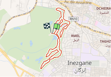
12.4 km | 15.4 km-effort
3h 8min
No
Trail Walking  - rando souk Agadir  - Photo
Walking
Maca8284

Walking

Easy
, Souss-Massa, Agadir, Morocco
2.7 km | 3 km-effort
46min
Yes


Close
My subscriptions