Trail Quad Maricourt - rando   villers bretonneux maricourt et retour - Photo

rando villers bretonneux maricourt et retour

© OpenStreetMap contributors
Length
Length
122 km
Max alt
Max alt
162 m
Uphill gradient
Uphill gradient
1306 m
Km-Effort
Km-Effort  
140 km
Min alt
Min alt
32 m
Downhill gradient
Downhill gradient
1303 m
Boucle
Boucle
Yes
Creation date :
2023-02-21 20:20:53.615
Updated on :
2023-02-21 20:30:28.956

(0 Reviews)

Quad
Quad
4h23
Difficulty : Very easy

Scan this QR Code to open this trail in the SityTrail application

FREE GPS app for hiking

Logo SityTrail SityTrail

IGN / Geographical institutes

Download SityTrail from the App Store Download SityTrail from Google Play

Logo SityTrail SityTrail World

The world is yours!

Download SityTrail from the App Store Download SityTrail from Google Play Download SityTrail on Huawei AppGallery

About

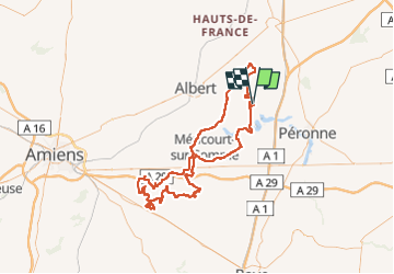
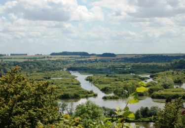
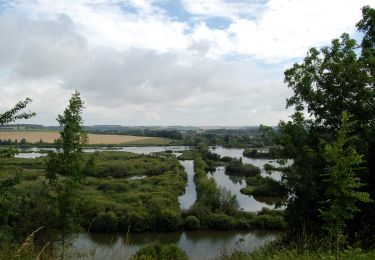
Trail Quad of 122 km to be discovered at Hauts-de-France, Somme, Maricourt. This trail is proposed by Eric Bottin.

Description

villers-bretonneux ,demuin  ,hangar , morcourt ,maricourt , cerisy albert , villers-bretonneux

Elevation profile

Points of interest

Point of interest Maricourt - terrain cross - Photo
Eric Bottin
MARICOURT 
Point of interest Villers-Bretonneux - depart ; villers bretonneux ,maricourt  ;retour villers bretonneux - Photo
Eric Bottin
VILLERS-BRETONNEUX 

Positioning

Country:
France
Region :
Hauts-de-France
Department/Province :
Somme
Municipality :
Maricourt
Location:
Unknown
Start:(UTM)
485319 ; 5535912 (31U) N.

Trails nearby

Trail Walking Curlu - tour des étangs de curlu - Photo
Walking
terminio

Walking

Very easy
Curlu, Hauts-de-France, Somme, France
10.5 km | 11.6 km-effort
2h 41min
Yes
Trail Walking Curlu - Autour des étangs de Curlu et Feuillères - Photo
Walking
terminio

Walking

Easy
(1)
Curlu, Hauts-de-France, Somme, France
11.6 km | 12.7 km-effort
3h 11min
Yes
Trail Other activity Éclusier-Vaux - Vaux - Marais de la Somme - Photo
Other activity
rarnaud

Other activity

Very easy
Éclusier-Vaux, Hauts-de-France, Somme, France
8.7 km | 10.1 km-effort
2h 13min
Yes
Trail Walking Frise - montagne de frise - Photo
Walking
Bernard.voyageur

Walking

Medium
(1)
Frise, Hauts-de-France, Somme, France
2 km | 2.5 km-effort
1h 0min
Yes
Trail Walking Curlu - Le chemin des Automitrailleuses - Curlu - Photo
Walking
tracegps

Walking

Medium
(1)
Curlu, Hauts-de-France, Somme, France
11 km | 12 km-effort
3h 19min
Yes
Trail Walking Éclusier-Vaux - La Montagne de Vaux - Photo
Walking
tracegps

Walking

Medium
Éclusier-Vaux, Hauts-de-France, Somme, France
8.7 km | 10.2 km-effort
3h 0min
Yes
Trail Walking Cappy - Circuit entre Terre et Eaux - Photo
Walking
corsinou

Walking

Easy
Cappy, Hauts-de-France, Somme, France
12.7 km | 15.2 km-effort
3h 32min
Yes
Trail Walking Éclusier-Vaux - Le larris de la montagne de Vaux - Photo
Walking
tracegps

Walking

Difficult
Éclusier-Vaux, Hauts-de-France, Somme, France
2.6 km | 3.5 km-effort
40min
Yes
Trail Walking Frise - Sur les pas de Blaise Cendrars - Photo
Walking
Jacky27340

Walking

Medium
Frise, Hauts-de-France, Somme, France
8.3 km | 9.4 km-effort
2h 14min
Yes


Close
My subscriptions