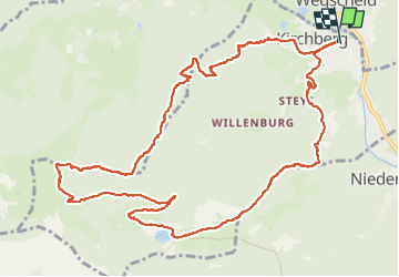
![](/images/other/stat-length.png)
![Trail Walking Kirchberg - Sommerseite 2023 - Photo](https://media.geolcdn.com/t/1900/400/c8b102ff-82a7-4c02-a07d-8f563b677150.jpg&format=pjpeg&maxdim=2)
Sommerseite 2023
helmut68
User
![Length](/images/other/stat-length.png)
![Max alt](https://static1.geolcdn.com/siteimages/upload/files/1508320355ic_sort_altitude_max_24dp.png)
![Uphill gradient](https://static1.geolcdn.com/siteimages/upload/files/1508320355ic_sort_den_pos_24dp.png)
![Km-Effort](/images/other/stat-length.png)
![Min alt](https://static1.geolcdn.com/siteimages/upload/files/1508320355ic_sort_altitude_min_24dp.png)
![Downhill gradient](https://static1.geolcdn.com/siteimages/upload/files/1508320355ic_sort_den_neg_24dp.png)
![Boucle](https://static1.geolcdn.com/siteimages/upload/files/16400158638029165_repeat_loop_refresh_sync_direction_icon.png)
![Walking](https://static1.geolcdn.com/sitytour/trail-icons/101.png)
4h12
Difficulty : Difficult
![Scan this QR Code to open this trail in the SityTrail application](https://capi.geolives.com/qq0zvz2zws4bq2lad0pu/sitytour/trails/3560494/qr.png?size=200)
FREE GPS app for hiking
About
Trail Walking of 13.5 km to be discovered at Grand Est, Haut-Rhin, Kirchberg. This trail is proposed by helmut68.
Description
Très belle boucle au départ et arrivée au parking en face de la mairie de Kirchberg . La montée à l'abri du Sommerseite est longue d' environ 5 km et difficile par moment , utilisez le balisage du club vosgien " triangle bleu " . Profitez sur les hauteurs des belles vues des villages de fin de vallée de la Doller ( Dolleren , Oberbruck , Rimbach ... ) ,et des sommets d'en face ( Ballon d' Alsace , Rosberg ... ) . Pour le retour suivez le balisage " anneau bleu " en passant devant la ferme auberge du Lochberg et du lac Lachtelweiher ( beaux nénuphars ) ,
Alors à vos chaussures !
Positioning
Comments
Trails nearby
![Trail Walking Masevaux-Niederbruck - Masevaux - Rossberg par le belvédère du Fuchsfelsen - Photo](https://media.geolcdn.com/t/375/260/d9cc765c-1250-4953-9d9f-fb8b88eb82a7.jpg&format=jpg&maxdim=2)
![Walking Walking](https://static1.geolcdn.com/sitytour/trail-icons/101.png)
Walking
![](/images/other/stat-length.png)
![](https://static1.geolcdn.com/siteimages/upload/files/16400158638029165_repeat_loop_refresh_sync_direction_icon.png)
![Trail Walking Rimbach-près-Masevaux - Haute Bers - Photo](https://media.geolcdn.com/t/375/260/263a149f-9c7c-4184-802a-631c78ca66f6.jpg&format=jpg&maxdim=2)
![Walking Walking](https://static1.geolcdn.com/sitytour/trail-icons/101.png)
Walking
![](/images/other/stat-length.png)
![](https://static1.geolcdn.com/siteimages/upload/files/16400158638029165_repeat_loop_refresh_sync_direction_icon.png)
![Trail Walking Sewen - Boucle entre les lacs de Sewen et d'Alfeld - Photo](https://media.geolcdn.com/t/375/260/ext.jpg?maxdim=2&url=https%3A%2F%2Fservices.sitytrail.com%2FGeolivesWS%2FDownloadMedia.ashx%3FTrailID%3D103686%26Media%3D6168_4.jpg)
![Walking Walking](https://static1.geolcdn.com/sitytour/trail-icons/101.png)
Walking
![](/images/other/stat-length.png)
![](https://static1.geolcdn.com/siteimages/upload/files/16400158638029165_repeat_loop_refresh_sync_direction_icon.png)
![Trail Walking Dolleren - 2025-01-03 Rando Polaire Dolleren Ballon Alsace Etape 2 - Photo](https://media.geolcdn.com/t/375/260/9acfce3f-2eaf-4a63-8eb3-62065bd107c3.jpg&format=jpg&maxdim=2)
![Walking Walking](https://static1.geolcdn.com/sitytour/trail-icons/101.png)
Walking
![](/images/other/stat-length.png)
![](https://static1.geolcdn.com/siteimages/upload/files/16400158638029165_repeat_loop_refresh_sync_direction_icon.png)
![Trail Walking Dolleren - suuntoapp-Hiking-2025-01-02T19-20-24Z - Photo](https://media.geolcdn.com/t/375/260/98b6c1e4-75f0-464a-86a1-edc427e75210.jpg&format=jpg&maxdim=2)
![Walking Walking](https://static1.geolcdn.com/sitytour/trail-icons/101.png)
Walking
![](/images/other/stat-length.png)
![](https://static1.geolcdn.com/siteimages/upload/files/16400158638029165_repeat_loop_refresh_sync_direction_icon.png)
![Trail Walking Kirchberg - 2022-07-15 Marche Refuge Baerenkopf Auberge Gazon Vert - Photo](https://media.geolcdn.com/t/375/260/d5c191fc-95a3-4bb1-8368-e694339cee76.jpg&format=jpg&maxdim=2)
![Walking Walking](https://static1.geolcdn.com/sitytour/trail-icons/101.png)
Walking
![](/images/other/stat-length.png)
![](https://static1.geolcdn.com/siteimages/upload/files/16400158638029165_repeat_loop_refresh_sync_direction_icon.png)
![Trail Walking Lauw - 2022-07-14 Marche Lauw Refuge CAF Baerenkopf - Photo](https://media.geolcdn.com/t/375/260/e2209d17-65ac-46f6-a404-5274e10a843e.jpg&format=jpg&maxdim=2)
![Walking Walking](https://static1.geolcdn.com/sitytour/trail-icons/101.png)
Walking
![](/images/other/stat-length.png)
![](https://static1.geolcdn.com/siteimages/upload/files/16400158638029165_repeat_loop_refresh_sync_direction_icon.png)
![Trail Walking Masevaux-Niederbruck - Reco avec ALAIN..Rando CLAS du 29/08/2024 - Photo](https://media.geolcdn.com/t/375/260/5dba7985-af1b-4076-a275-05f9cb5145f8.jpg&format=jpg&maxdim=2)
![Walking Walking](https://static1.geolcdn.com/sitytour/trail-icons/101.png)
Walking
![](/images/other/stat-length.png)
![](https://static1.geolcdn.com/siteimages/upload/files/16400158638029165_repeat_loop_refresh_sync_direction_icon.png)
![Trail Walking Rimbach-près-Masevaux - Les deux lacs - Photo](https://media.geolcdn.com/t/375/260/ec102df6-1fd0-42bb-8bbd-9523bd80f1a9.jpg&format=jpg&maxdim=2)
![Walking Walking](https://static1.geolcdn.com/sitytour/trail-icons/101.png)
Walking
![](/images/other/stat-length.png)
![](https://static1.geolcdn.com/siteimages/upload/files/16400158638029165_repeat_loop_refresh_sync_direction_icon.png)