cas ades d'ouzoud SityTrail > Trails > Outdoor > Morocco > Béni Mellal-Khénifra > cercle de Bzou > Ait Taguella SityTrail > Trails > Outdoor > Morocco > Béni Mellal-Khénifra > cercle de Bzou > Ait Taguella cas ades d'ouzoud carole5983 User 3D © OpenStreetMap contributors Length 2.5 km Max alt 799 m Uphill gradient 112 m Km-Effort 4 km Min alt 688 m Downhill gradient 115 m Boucle Yes Creation date : 2023-02-21 08:55:19.679 Updated on : 2023-02-21 11:40:09.316 (0 Reviews) Walking 2h44 Difficulty : Very easy FREE GPS app for hiking SityTrail IGN / Geographical institutes SityTrail World The world is yours! About 
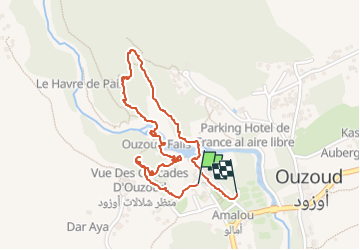
Trail Walking of 2.5 km to be discovered at Béni Mellal-Khénifra, cercle de Bzou, Ait Taguella. This trail is proposed by carole5983. Description Dénivelé 110 m Legends | More details (PDF) Elevation profile Legends > 15% 15% - 10% 10% - 5% flat 5% - 10% 10% - 15% 15% - 30% > 30% Positioning Country: Morocco Region : Béni Mellal-Khénifra Department/Province : cercle de Bzou Municipality : Ait Taguella Location: Unknown Start:(Dec) 32.0141679 / -6.7191755 Start:(UTM) 715428 ; 3544280 (29S) N. Comments Please log in to post a review or rate the element Trails nearby jpmv meknes Car Very easy Ait Ouaarda, Béni Mellal-Khénifra, cercle d'Afourar, Morocco 305 km | 353 km-effort 6h 54min No