![](/images/other/stat-length.png)
![Trail On foot Verrières-le-Buisson - bois de verrière et vallée de la Bièvre - Photo](https://media.geolcdn.com/t/1900/400/ext.pjpeg?maxdim=2&url=https%3A%2F%2Fstatic1.geolcdn.com%2Fsiteimages%2Fupload%2Ffiles%2F1545311037marcheuse_200dpi.jpg)
bois de verrière et vallée de la Bièvre
Jean Pierre Parent
User
![Length](/images/other/stat-length.png)
Length
21 km
![Max alt](https://static1.geolcdn.com/siteimages/upload/files/1508320355ic_sort_altitude_max_24dp.png)
Max alt
182 m
![Uphill gradient](https://static1.geolcdn.com/siteimages/upload/files/1508320355ic_sort_den_pos_24dp.png)
Uphill gradient
342 m
![Km-Effort](/images/other/stat-length.png)
Km-Effort
25 km
![Min alt](https://static1.geolcdn.com/siteimages/upload/files/1508320355ic_sort_altitude_min_24dp.png)
Min alt
64 m
![Downhill gradient](https://static1.geolcdn.com/siteimages/upload/files/1508320355ic_sort_den_neg_24dp.png)
Downhill gradient
342 m
![Boucle](https://static1.geolcdn.com/siteimages/upload/files/16400158638029165_repeat_loop_refresh_sync_direction_icon.png)
Boucle
Yes
Creation date :
2023-02-19 09:55:06.762
Updated on :
2023-04-10 12:34:49.061
![On foot](https://static1.geolcdn.com/sitytour/trail-icons/100.png)
5h47
Difficulty : Medium
![Walking](https://static1.geolcdn.com/sitytour/trail-icons/101.png)
5h47
Difficulty : Very difficult
![Scan this QR Code to open this trail in the SityTrail application](https://capi.geolives.com/qq0zvz2zws4bq2lad0pu/sitytour/trails/3557037/qr.png?size=200)
FREE GPS app for hiking
About
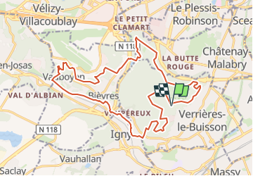
Trail On foot of 21 km to be discovered at Ile-de-France, Essonne, Verrières-le-Buisson. This trail is proposed by Jean Pierre Parent.
Description
Mélange de forêt, de vallée avec un peu de dénivelé.
PS : Descente de la forêt de Verrière vers la Bièvre est assez raide et les bâtons sont les biens venus.
Positioning
Country:
France
Region :
Ile-de-France
Department/Province :
Essonne
Municipality :
Verrières-le-Buisson
Location:
Unknown
Start:(Dec)
Start:(UTM)
444897 ; 5400096 (31U) N.
Comments
Trails nearby
![Trail Walking Bièvres - De Bièvres à Antony - Photo](https://media.geolcdn.com/t/375/260/ext.jpg?maxdim=2&url=https%3A%2F%2Fservices.sitytrail.com%2FGeolivesWS%2FDownloadMedia.ashx%3FTrailID%3D106789%26Media%3D11480_3.jpg)
![Walking Walking](https://static1.geolcdn.com/sitytour/trail-icons/101.png)
De Bièvres à Antony
Walking
Medium
(1)
Bièvres,
Ile-de-France,
Essonne,
France
![](/images/other/stat-length.png)
11.9 km | 14 km-effort
3h 0min
![](https://static1.geolcdn.com/siteimages/upload/files/16400158638029165_repeat_loop_refresh_sync_direction_icon.png)
No
![Trail Walking Verrières-le-Buisson - Sur les sentiers de découverte du Bois de Verrières - Photo](https://media.geolcdn.com/t/375/260/ext.jpg?maxdim=2&url=https%3A%2F%2Fservices.sitytrail.com%2FGeolivesWS%2FDownloadMedia.ashx%3FTrailID%3D110232%26Media%3D5500_1.jpg)
![Walking Walking](https://static1.geolcdn.com/sitytour/trail-icons/101.png)
Sur les sentiers de découverte du Bois de Verrières
Walking
Medium
(2)
Verrières-le-Buisson,
Ile-de-France,
Essonne,
France
![](/images/other/stat-length.png)
22 km | 27 km-effort
4h 40min
![](https://static1.geolcdn.com/siteimages/upload/files/16400158638029165_repeat_loop_refresh_sync_direction_icon.png)
Yes
![Trail Walking Sceaux - Les Hauts de Bièvre - Photo](https://media.geolcdn.com/t/375/260/ext.jpg?maxdim=2&url=https%3A%2F%2Fservices.sitytrail.com%2FGeolivesWS%2FDownloadMedia.ashx%3FTrailID%3D110019%26Media%3D5127_1.jpg)
![Walking Walking](https://static1.geolcdn.com/sitytour/trail-icons/101.png)
Les Hauts de Bièvre
Walking
Difficult
(2)
Sceaux,
Ile-de-France,
Hauts-de-Seine,
France
![](/images/other/stat-length.png)
25 km | 30 km-effort
6h 0min
![](https://static1.geolcdn.com/siteimages/upload/files/16400158638029165_repeat_loop_refresh_sync_direction_icon.png)
Yes
![Trail Walking Bièvres - Autour de Bièvres - Photo](https://media.geolcdn.com/t/375/260/ext.jpg?maxdim=2&url=https%3A%2F%2Fservices.sitytrail.com%2FGeolivesWS%2FDownloadMedia.ashx%3FTrailID%3D102999%26Media%3D4541_2.jpg)
![Walking Walking](https://static1.geolcdn.com/sitytour/trail-icons/101.png)
Autour de Bièvres
Walking
Medium
(4)
Bièvres,
Ile-de-France,
Essonne,
France
![](/images/other/stat-length.png)
7.6 km | 9.4 km-effort
2h 30min
![](https://static1.geolcdn.com/siteimages/upload/files/16400158638029165_repeat_loop_refresh_sync_direction_icon.png)
Yes
![Trail Walking Igny - tour du plateau de Saclay V2 - Photo](https://media.geolcdn.com/t/375/260/ext.jpg?maxdim=2&url=https%3A%2F%2Fstatic1.geolcdn.com%2Fsiteimages%2Fupload%2Ffiles%2F1553511878bg_sport_marche.png)
![Walking Walking](https://static1.geolcdn.com/sitytour/trail-icons/101.png)
tour du plateau de Saclay V2
Walking
Very difficult
(1)
Igny,
Ile-de-France,
Essonne,
France
![](/images/other/stat-length.png)
21 km | 25 km-effort
5h 36min
![](https://static1.geolcdn.com/siteimages/upload/files/16400158638029165_repeat_loop_refresh_sync_direction_icon.png)
Yes
![Trail Walking Fontenay-aux-Roses - Rando des 3 Parcs ! (des Gares RER) - Photo](https://media.geolcdn.com/t/375/260/ext.jpg?maxdim=2&url=https%3A%2F%2Fstatic1.geolcdn.com%2Fsiteimages%2Fupload%2Ffiles%2F1553511878bg_sport_marche.png)
![Walking Walking](https://static1.geolcdn.com/sitytour/trail-icons/101.png)
Rando des 3 Parcs ! (des Gares RER)
Walking
Very difficult
(2)
Fontenay-aux-Roses,
Ile-de-France,
Hauts-de-Seine,
France
![](/images/other/stat-length.png)
15.9 km | 19.5 km-effort
4h 26min
![](https://static1.geolcdn.com/siteimages/upload/files/16400158638029165_repeat_loop_refresh_sync_direction_icon.png)
No
![Trail Walking Sceaux - Boucle autour du parc de Sceaux - Photo](https://media.geolcdn.com/t/375/260/a68a703b-59c1-496c-bcd2-be669bbe22a1.jpg&format=jpg&maxdim=2)
![Walking Walking](https://static1.geolcdn.com/sitytour/trail-icons/101.png)
Boucle autour du parc de Sceaux
Walking
Very easy
Sceaux,
Ile-de-France,
Hauts-de-Seine,
France
![](/images/other/stat-length.png)
19 km | 23 km-effort
4h 24min
![](https://static1.geolcdn.com/siteimages/upload/files/16400158638029165_repeat_loop_refresh_sync_direction_icon.png)
Yes
![Trail Walking Verrières-le-Buisson - Boucle autour de Verrières le Buisson - Photo](https://media.geolcdn.com/t/375/260/e3400994-d836-42da-a137-76fd998d9849.jpg&format=jpg&maxdim=2)
![Walking Walking](https://static1.geolcdn.com/sitytour/trail-icons/101.png)
Boucle autour de Verrières le Buisson
Walking
Medium
Verrières-le-Buisson,
Ile-de-France,
Essonne,
France
![](/images/other/stat-length.png)
25 km | 31 km-effort
5h 22min
![](https://static1.geolcdn.com/siteimages/upload/files/16400158638029165_repeat_loop_refresh_sync_direction_icon.png)
Yes
![Trail Walking Antony - Boucle Antony - Chatenay - Igny - Bièvres - Photo](https://media.geolcdn.com/t/375/260/26d35776-e0b1-40e5-952d-c653b146e131.jpg&format=jpg&maxdim=2)
![Walking Walking](https://static1.geolcdn.com/sitytour/trail-icons/101.png)
Boucle Antony - Chatenay - Igny - Bièvres
Walking
Easy
Antony,
Ile-de-France,
Hauts-de-Seine,
France
![](/images/other/stat-length.png)
24 km | 30 km-effort
5h 31min
![](https://static1.geolcdn.com/siteimages/upload/files/16400158638029165_repeat_loop_refresh_sync_direction_icon.png)
Yes