Trail On foot Veyre-Monton - Veyre Monton le puy de marmant - Photo

Veyre Monton le puy de marmant

 jeanic63
jeanic63

User

© OpenStreetMap contributors
Length
Length
8.9 km
Max alt
Max alt
479 m
Uphill gradient
Uphill gradient
271 m
Km-Effort
Km-Effort  
12.5 km
Min alt
Min alt
371 m
Downhill gradient
Downhill gradient
268 m
Boucle
Boucle
Yes
Creation date :
2023-02-18 17:28:43.25
Updated on :
2023-02-27 18:00:17.467

(0 Reviews)

On foot
On foot
2h58
Difficulty : Easy

Scan this QR Code to open this trail in the SityTrail application

FREE GPS app for hiking

Logo SityTrail SityTrail

IGN / Geographical institutes

Download SityTrail from the App Store Download SityTrail from Google Play

Logo SityTrail SityTrail World

The world is yours!

Download SityTrail from the App Store Download SityTrail from Google Play Download SityTrail on Huawei AppGallery

About

Trail On foot of 8.9 km to be discovered at Auvergne-Rhône-Alpes, Puy-de-Dôme, Veyre-Monton. This trail is proposed by jeanic63.

Description

départ restaurant la brique rouge à Veyre  monton si  repas au restaurant sinon à l'intersection  de laD978 et la D787

Elevation profile

Positioning

Country:
France
Region :
Auvergne-Rhône-Alpes
Department/Province :
Puy-de-Dôme
Municipality :
Veyre-Monton
Location:
Unknown
Start:(UTM)
513517 ; 5059185 (31T) N.

Trails nearby

Trail Walking Le Cendre - Le_Cendre_Tour_1 - Photo
Walking
GUIDE
jagarnier

Walking

Easy
(1)
Le Cendre, Auvergne-Rhône-Alpes, Puy-de-Dôme, France
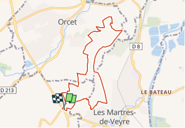
8.2 km | 10.1 km-effort
2h 30min
Yes
Trail On foot Le Cendre - De l'Auzon a Gondole - Photo
On foot
GUIDE+

On foot

Easy
Le Cendre, Auvergne-Rhône-Alpes, Puy-de-Dôme, France
6.8 km | 7.7 km-effort
1h 44min
Yes
Trail On foot Veyre-Monton - Le Puy de Corent - Photo
On foot
GUIDE+

On foot

Easy
Veyre-Monton, Auvergne-Rhône-Alpes, Puy-de-Dôme, France
5.8 km | 8.3 km-effort
1h 52min
Yes
Trail On foot Saint-Amant-Tallende - Le Puy de Peyronere - Photo
On foot
GUIDE+

On foot

Easy
Saint-Amant-Tallende, Auvergne-Rhône-Alpes, Puy-de-Dôme, France
9.5 km | 13 km-effort
2h 57min
Yes
Trail On foot La Roche-Blanche - Le Plateau de Gergovie - Photo
On foot
GUIDE+

On foot

Easy
La Roche-Blanche, Auvergne-Rhône-Alpes, Puy-de-Dôme, France
3.5 km | 4.4 km-effort
59min
Yes
Trail Walking La Roche-Blanche - Gergovie - Photo
Walking
scheat

Walking

Easy
(1)
La Roche-Blanche, Auvergne-Rhône-Alpes, Puy-de-Dôme, France
3.5 km | 4.3 km-effort
56min
Yes
Trail Equestrian Authezat - 20km Chadieu - Photo
Equestrian
clement63

Equestrian

Medium
(1)
Authezat, Auvergne-Rhône-Alpes, Puy-de-Dôme, France
22 km | 26 km-effort
3h 21min
Yes
Trail Mountain bike Orcet - vtt depart Orcet - Photo
Mountain bike
corzevasion

Mountain bike

Medium
(1)
Orcet, Auvergne-Rhône-Alpes, Puy-de-Dôme, France
45 km | 57 km-effort
3h 40min
Yes
Trail Walking Tallende - Tallende_Vergers - Photo
Walking
GUIDE
jagarnier

Walking

Easy
Tallende, Auvergne-Rhône-Alpes, Puy-de-Dôme, France
8.3 km | 10.5 km-effort
2h 30min
Yes


Close
My subscriptions