![](/images/other/stat-length.png)
![Trail Mountain bike La Chapelle-sur-Erdre - Erdre Cens et Gesvre - Photo](https://media.geolcdn.com/t/1900/400/ext.pjpeg?maxdim=2&url=https%3A%2F%2Fstatic1.geolcdn.com%2Fsiteimages%2Fupload%2Ffiles%2F1524743154velo.jpg)
Erdre Cens et Gesvre
Ajax44
User
![Length](/images/other/stat-length.png)
Length
28 km
![Max alt](https://static1.geolcdn.com/siteimages/upload/files/1508320355ic_sort_altitude_max_24dp.png)
Max alt
74 m
![Uphill gradient](https://static1.geolcdn.com/siteimages/upload/files/1508320355ic_sort_den_pos_24dp.png)
Uphill gradient
306 m
![Km-Effort](/images/other/stat-length.png)
Km-Effort
32 km
![Min alt](https://static1.geolcdn.com/siteimages/upload/files/1508320355ic_sort_altitude_min_24dp.png)
Min alt
3 m
![Downhill gradient](https://static1.geolcdn.com/siteimages/upload/files/1508320355ic_sort_den_neg_24dp.png)
Downhill gradient
301 m
![Boucle](https://static1.geolcdn.com/siteimages/upload/files/16400158638029165_repeat_loop_refresh_sync_direction_icon.png)
Boucle
Yes
Creation date :
2023-02-13 12:46:17.937
Updated on :
2023-02-13 16:30:05.839
![Mountain bike](https://static1.geolcdn.com/sitytour/trail-icons/202.png)
1h58
Difficulty : Difficult
![Scan this QR Code to open this trail in the SityTrail application](https://capi.geolives.com/qq0zvz2zws4bq2lad0pu/sitytour/trails/3550611/qr.png?size=200)
FREE GPS app for hiking
About
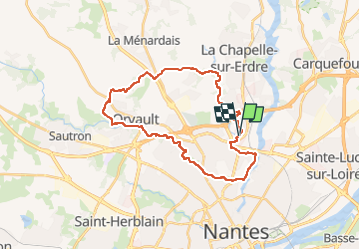
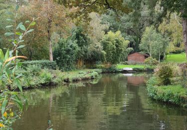
Trail Mountain bike of 28 km to be discovered at Pays de la Loire, Loire-Atlantique, La Chapelle-sur-Erdre. This trail is proposed by Ajax44.
Description
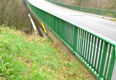
Randonnée réalisée en VTTAE, le long du Gesvres quelques passages demandent de mettre le pieds a terre.
Positioning
Country:
France
Region :
Pays de la Loire
Department/Province :
Loire-Atlantique
Municipality :
La Chapelle-sur-Erdre
Location:
Unknown
Start:(Dec)
Start:(UTM)
609553 ; 5235445 (30T) N.
Comments
Trails nearby
![Trail On foot La Chapelle-sur-Erdre - grand circuit Erdre/Gesvres - Photo](https://media.geolcdn.com/t/375/260/36b563d8-5e42-407f-af20-6207f8d9317f.jpeg&format=jpg&maxdim=2)
![On foot On foot](https://static1.geolcdn.com/sitytour/trail-icons/100.png)
grand circuit Erdre/Gesvres
On foot
Easy
La Chapelle-sur-Erdre,
Pays de la Loire,
Loire-Atlantique,
France
![](/images/other/stat-length.png)
4.2 km | 5.2 km-effort
1h 10min
![](https://static1.geolcdn.com/siteimages/upload/files/16400158638029165_repeat_loop_refresh_sync_direction_icon.png)
No
![Trail Walking Nantes - Nantes chezine-chantenay - Photo](https://media.geolcdn.com/t/375/260/ext.jpg?maxdim=2&url=https%3A%2F%2Fstatic1.geolcdn.com%2Fsiteimages%2Fupload%2Ffiles%2F1553511878bg_sport_marche.png)
![Walking Walking](https://static1.geolcdn.com/sitytour/trail-icons/101.png)
Nantes chezine-chantenay
Walking
Very easy
(1)
Nantes,
Pays de la Loire,
Loire-Atlantique,
France
![](/images/other/stat-length.png)
9.5 km | 11.1 km-effort
2h 26min
![](https://static1.geolcdn.com/siteimages/upload/files/16400158638029165_repeat_loop_refresh_sync_direction_icon.png)
Yes
![Trail Mountain bike Nantes - Nantes - Photo](https://media.geolcdn.com/t/375/260/ext.jpg?maxdim=2&url=https%3A%2F%2Fstatic1.geolcdn.com%2Fsiteimages%2Fupload%2Ffiles%2F1524743154velo.jpg)
![Mountain bike Mountain bike](https://static1.geolcdn.com/sitytour/trail-icons/202.png)
Nantes
Mountain bike
Medium
(1)
Nantes,
Pays de la Loire,
Loire-Atlantique,
France
![](/images/other/stat-length.png)
32 km | 38 km-effort
2h 6min
![](https://static1.geolcdn.com/siteimages/upload/files/16400158638029165_repeat_loop_refresh_sync_direction_icon.png)
Yes
![Trail Walking Carquefou - Carquefou les hauts - Photo](https://media.geolcdn.com/t/375/260/ext.jpg?maxdim=2&url=https%3A%2F%2Fstatic1.geolcdn.com%2Fsiteimages%2Fupload%2Ffiles%2F1553511878bg_sport_marche.png)
![Walking Walking](https://static1.geolcdn.com/sitytour/trail-icons/101.png)
Carquefou les hauts
Walking
Easy
(2)
Carquefou,
Pays de la Loire,
Loire-Atlantique,
France
![](/images/other/stat-length.png)
10.3 km | 11.6 km-effort
2h 34min
![](https://static1.geolcdn.com/siteimages/upload/files/16400158638029165_repeat_loop_refresh_sync_direction_icon.png)
Yes
![Trail On foot La Chapelle-sur-Erdre - La Source, Le Rupt, l'ancienne voie de chemin de fer - Photo](https://media.geolcdn.com/t/375/260/dd46a926-2019-47c5-9f72-3994a23fb768.jpeg&format=jpg&maxdim=2)
![On foot On foot](https://static1.geolcdn.com/sitytour/trail-icons/100.png)
La Source, Le Rupt, l'ancienne voie de chemin de fer
On foot
Easy
La Chapelle-sur-Erdre,
Pays de la Loire,
Loire-Atlantique,
France
![](/images/other/stat-length.png)
5.5 km | 6.2 km-effort
1h 25min
![](https://static1.geolcdn.com/siteimages/upload/files/16400158638029165_repeat_loop_refresh_sync_direction_icon.png)
No
![Trail On foot Carquefou - Les Bords de l'Erdre - Photo](https://media.geolcdn.com/t/375/260/c7417e76-e2f6-40cc-bd1f-087623dde044.jpeg&format=jpg&maxdim=2)
![On foot On foot](https://static1.geolcdn.com/sitytour/trail-icons/100.png)
Les Bords de l'Erdre
On foot
Easy
Carquefou,
Pays de la Loire,
Loire-Atlantique,
France
![](/images/other/stat-length.png)
4.4 km | 5 km-effort
1h 8min
![](https://static1.geolcdn.com/siteimages/upload/files/16400158638029165_repeat_loop_refresh_sync_direction_icon.png)
No
![Trail Mountain bike La Chapelle-sur-Erdre - gr3 et vallée du cens - Photo](https://media.geolcdn.com/t/375/260/ext.jpg?maxdim=2&url=https%3A%2F%2Fstatic1.geolcdn.com%2Fsiteimages%2Fupload%2Ffiles%2F1524743154velo.jpg)
![Mountain bike Mountain bike](https://static1.geolcdn.com/sitytour/trail-icons/202.png)
gr3 et vallée du cens
Mountain bike
Easy
(1)
La Chapelle-sur-Erdre,
Pays de la Loire,
Loire-Atlantique,
France
![](/images/other/stat-length.png)
25 km | 30 km-effort
Unknown
![](https://static1.geolcdn.com/siteimages/upload/files/16400158638029165_repeat_loop_refresh_sync_direction_icon.png)
Yes
![Trail Hybrid bike Nantes - etape n°1 l'hippodrome université Nantes à Plessis pas Brunet - Photo](https://media.geolcdn.com/t/375/260/f11b735e-088e-4766-b0fc-11001b7156c1.jpg&format=jpg&maxdim=2)
![Hybrid bike Hybrid bike](https://static1.geolcdn.com/sitytour/trail-icons/203.png)
etape n°1 l'hippodrome université Nantes à Plessis pas Brunet
Hybrid bike
Easy
Nantes,
Pays de la Loire,
Loire-Atlantique,
France
![](/images/other/stat-length.png)
30 km | 33 km-effort
2h 48min
![](https://static1.geolcdn.com/siteimages/upload/files/16400158638029165_repeat_loop_refresh_sync_direction_icon.png)
No
![Trail Walking La Chapelle-sur-Erdre - La Chapelle Erdre Gascherie - Photo](https://media.geolcdn.com/t/375/260/6320ae57-0364-4b55-88d0-a7ec8f53670f.jpg&format=jpg&maxdim=2)
![Walking Walking](https://static1.geolcdn.com/sitytour/trail-icons/101.png)
La Chapelle Erdre Gascherie
Walking
Medium
(1)
La Chapelle-sur-Erdre,
Pays de la Loire,
Loire-Atlantique,
France
![](/images/other/stat-length.png)
9.2 km | 10.1 km-effort
2h 19min
![](https://static1.geolcdn.com/siteimages/upload/files/16400158638029165_repeat_loop_refresh_sync_direction_icon.png)
Yes