Trail Walking Cormoranche-sur-Saône - Cormoranche /Saône: voie bleue et village - Photo

Cormoranche /Saône: voie bleue et village

© OpenStreetMap contributors
Length
Length
7.6 km
Max alt
Max alt
179 m
Uphill gradient
Uphill gradient
42 m
Km-Effort
Km-Effort  
8.2 km
Min alt
Min alt
166 m
Downhill gradient
Downhill gradient
41 m
Boucle
Boucle
Yes
Creation date :
2023-02-11 13:19:48.0
Updated on :
2023-02-11 16:44:38.09

(0 Reviews)

Walking
Walking
1h57
Difficulty : Very easy

Scan this QR Code to open this trail in the SityTrail application

FREE GPS app for hiking

Logo SityTrail SityTrail

IGN / Geographical institutes

Download SityTrail from the App Store Download SityTrail from Google Play

Logo SityTrail SityTrail World

The world is yours!

Download SityTrail from the App Store Download SityTrail from Google Play Download SityTrail on Huawei AppGallery

About

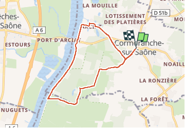
Trail Walking of 7.6 km to be discovered at Auvergne-Rhône-Alpes, Ain, Cormoranche-sur-Saône. This trail is proposed by robertdurand.

Description

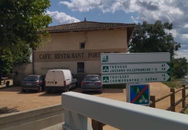
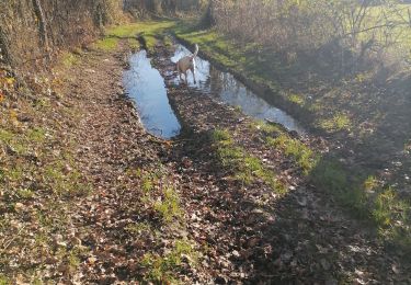
Du centre du village, nous allons en direction de la Saône où des travaux sur la rive crée une véloroute appelée voie bleue

Elevation profile

Positioning

Country:
France
Region :
Auvergne-Rhône-Alpes
Department/Province :
Ain
Municipality :
Cormoranche-sur-Saône
Location:
Unknown
Start:(UTM)
641156 ; 5122319 (31T) N.

Trails nearby

Trail Road bike Cormoranche-sur-Saône - 01 voie verte et bleue macon - Photo
Road bike
GUIDE
randodyssée

Road bike

Medium
Cormoranche-sur-Saône, Auvergne-Rhône-Alpes, Ain, France
74 km | 84 km-effort
4h 45min
Yes
Trail Walking Vinzelles - Vinzelles - Photo
Walking
janussity

Walking

Easy
(1)
Vinzelles, Bourgogne-Franche-Comté, Saône-et-Loire, France
7.8 km | 10.1 km-effort
2h 6min
Yes
Trail On foot Mâcon - sejour-rcy-les-cretes-du-haut-beaujolais-journee-1-nhUCI6cmgv - Photo
On foot
GUIDE
chessyca

On foot

Difficult
Mâcon, Bourgogne-Franche-Comté, Saône-et-Loire, France
23 km | 35 km-effort
8h 2min
No
Trail Walking La Chapelle-de-Guinchay - 10 - Photo
Walking
Chrystele Lafont

Walking

Medium
La Chapelle-de-Guinchay, Bourgogne-Franche-Comté, Saône-et-Loire, France
9.8 km | 11.2 km-effort
2h 41min
Yes
Trail Walking La Chapelle-de-Guinchay - massonay - Photo
Walking
Chrystele Lafont

Walking

Medium
La Chapelle-de-Guinchay, Bourgogne-Franche-Comté, Saône-et-Loire, France
9 km | 9.7 km-effort
2h 19min
Yes
Trail Walking Mâcon - Loché roche de Vergisson Roche de Solutré mont de Pouilly - Photo
Walking
Jackoyo

Walking

Medium
Mâcon, Bourgogne-Franche-Comté, Saône-et-Loire, France
28 km | 39 km-effort
7h 1min
Yes
Trail Walking La Chapelle-de-Guinchay - 8 - Photo
Walking
Chrystele Lafont

Walking

Medium
La Chapelle-de-Guinchay, Bourgogne-Franche-Comté, Saône-et-Loire, France
7.6 km | 8.9 km-effort
1h 58min
Yes
Trail Mountain bike Pont-de-Veyle - Ain et voie bleue - Photo
Mountain bike
janussity

Mountain bike

Medium
Pont-de-Veyle, Auvergne-Rhône-Alpes, Ain, France
24 km | 26 km-effort
1h 43min
Yes
Trail Coupling Garnerans - Beau Dimanche 2023 attelages-16167373 - Photo
Coupling
Ferme-Passion

Coupling

Very easy
Garnerans, Auvergne-Rhône-Alpes, Ain, France
28 km | 32 km-effort
Unknown
Yes


Close
My subscriptions