Trail Walking Schirmeck - Montagne sacrée du Donon depuis Schirmeck - Photo

Montagne sacrée du Donon depuis Schirmeck

 Bart2015
Bart2015

User

© OpenStreetMap contributors
Length
Length
20 km
Max alt
Max alt
996 m
Uphill gradient
Uphill gradient
759 m
Km-Effort
Km-Effort  
30 km
Min alt
Min alt
310 m
Downhill gradient
Downhill gradient
759 m
Boucle
Boucle
Yes
Creation date :
2023-02-11 09:10:11.617
Updated on :
2023-02-13 11:55:10.157

(1 Reviews)

Walking
Walking
4h28
Difficulty : Difficult

Scan this QR Code to open this trail in the SityTrail application

FREE GPS app for hiking

Logo SityTrail SityTrail

IGN / Geographical institutes

Download SityTrail from the App Store Download SityTrail from Google Play

Logo SityTrail SityTrail World

The world is yours!

Download SityTrail from the App Store Download SityTrail from Google Play Download SityTrail on Huawei AppGallery

About

Trail Walking of 20 km to be discovered at Grand Est, Bas-Rhin, Schirmeck. This trail is proposed by Bart2015.

Description

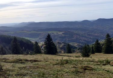
Le site du Donon constitue avec ses 1009 m d'altitude le point culminant des basses-Vosges, à la jonction des provinces alsacienne et lorraine. Dès la préhistoire, parce qu'il est visible de loin, on lui attribue un caractère sacré qui ne le quittera plus. Cette rando vous y conduit par une belle forêt avant de terminer l'ascension qui peut être délicate en hiver si les chemins sont verglacés. Bonnes chaussures et bâtons fortement recommandés.  De là-haut la vue est magnifique, peut-être un peu mystique ...
Bonne rando ...

Elevation profile

Photos

24 photos in total. Please click on a photo to see them all in the gallery.

Positioning

Country:
France
Region :
Grand Est
Department/Province :
Bas-Rhin
Municipality :
Schirmeck
Location:
Unknown
Start:(UTM)
368197 ; 5371211 (32U) N.

Comments

Please log in to post a review or rate the element


Trails nearby

Trail Walking Grandfontaine - Le site des 2 Donons - Photo
Walking
VacheKiri67

Walking

Medium
(4)
Grandfontaine, Grand Est, Bas-Rhin, France
12.6 km | 19.4 km-effort
4h 52min
Yes
Trail Walking La Broque - suuntoapp-Hiking-2024-03-17T08-46-21Z - Photo
Walking
GUIDE
holtzv

Walking

Easy
La Broque, Grand Est, Bas-Rhin, France
23 km | 35 km-effort
7h 55min
Yes
Trail Walking Lutzelhouse - suuntoapp-Hiking-2024-01-28T11-41-12Z - Photo
Walking
GUIDE
holtzv

Walking

Medium
Lutzelhouse, Grand Est, Bas-Rhin, France
15.3 km | 25 km-effort
5h 45min
Yes
Trail Horseback riding Barembach - 2022-10-30 Journée Rothau Struthof Serva Perheux - Photo
Horseback riding
GUIDE
holtzv

Horseback riding

Difficult
Barembach, Grand Est, Bas-Rhin, France
25 km | 37 km-effort
5h 31min
Yes
Trail Horseback riding Lutzelhouse - 2021-07-18 Journée Le petit Wisches Le Noll - Photo
Horseback riding
GUIDE
holtzv

Horseback riding

Difficult
Lutzelhouse, Grand Est, Bas-Rhin, France
22 km | 32 km-effort
4h 55min
Yes
Trail Walking Lutzelhouse - 2019-11-30 Marche Rocher de Mutzig Noll - Photo
Walking
GUIDE
holtzv

Walking

Very easy
Lutzelhouse, Grand Est, Bas-Rhin, France
18.7 km | 29 km-effort
4h 39min
Yes
Trail Horseback riding Wisches - 2019-08-24 Picnic Russ Colbery Abri du sanglier - Photo
Horseback riding
GUIDE
holtzv

Horseback riding

Very easy
Wisches, Grand Est, Bas-Rhin, France
15.5 km | 22 km-effort
3h 16min
Yes
Trail Walking Wisches - Wisches - circuit 1 des sculptures - Photo
Walking
Bart2015

Walking

Difficult
Wisches, Grand Est, Bas-Rhin, France
8.5 km | 12.4 km-effort
2h 48min
Yes
Trail Walking Grandfontaine - les deux donons - Photo
Walking
dragonchef

Walking

Difficult
Grandfontaine, Grand Est, Bas-Rhin, France
12.5 km | 19 km-effort
4h 16min
Yes


Close
My subscriptions