9 km | 14.2 km-effort
Circuit du grand Duc
ETMU5496
User
Length
12.2 km
Max alt
483 m
Uphill gradient
391 m
Km-Effort
17.4 km
Min alt
248 m
Downhill gradient
390 m
Boucle
Yes
Creation date :
2023-02-04 09:31:33.0
Updated on :
2023-02-04 14:11:42.31
3h19
Difficulty : Medium
FREE GPS app for hiking
About
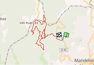
Trail Walking of 12.2 km to be discovered at Provence-Alpes-Côte d'Azur, Maritime Alps, Mandelieu-la-Napoule. This trail is proposed by ETMU5496.
Description
Circuit mimosa au départ de Mandelieu-la-Napoule
Positioning
Country:
France
Region :
Provence-Alpes-Côte d'Azur
Department/Province :
Maritime Alps
Municipality :
Mandelieu-la-Napoule
Location:
Unknown
Start:(Dec)
Start:(UTM)
332066 ; 4824513 (32T) N.
Comments
Trails nearby
Mont Saint Martin
Walking
Easy
(1)
Mandelieu-la-Napoule,
Provence-Alpes-Côte d'Azur,
Maritime Alps,
France
3h 0min
Yes
Tanneron les mimosas
Walking
Very easy
(1)
Tanneron,
Provence-Alpes-Côte d'Azur,
Var,
France
12 km | 17.8 km-effort
3h 25min
Yes
Tanneron - petite boucle 12-02-2022
Walking
Easy
Tanneron,
Provence-Alpes-Côte d'Azur,
Var,
France
7.5 km | 10.8 km-effort
2h 0min
Yes
Grand Duc Alternatif
Walking
Very easy
(1)
Mandelieu-la-Napoule,
Provence-Alpes-Côte d'Azur,
Maritime Alps,
France
6.4 km | 9.1 km-effort
2h 0min
Yes
"Les oeufs de bouc"
Walking
Medium
Mandelieu-la-Napoule,
Provence-Alpes-Côte d'Azur,
Maritime Alps,
France
14.5 km | 22 km-effort
6h 42min
Yes
Grand Duc
Walking
Medium
Mandelieu-la-Napoule,
Provence-Alpes-Côte d'Azur,
Maritime Alps,
France
8.9 km | 12.5 km-effort
2h 47min
Yes
Crêtes du Tanneron
Walking
Difficult
Tanneron,
Provence-Alpes-Côte d'Azur,
Var,
France
14.9 km | 21 km-effort
5h 5min
Yes
châteaux de la Napoule
Walking
Easy
Mandelieu-la-Napoule,
Provence-Alpes-Côte d'Azur,
Maritime Alps,
France
5.6 km | 7.8 km-effort
2h 23min
Yes
Tanneron
sport
Very easy
Tanneron,
Provence-Alpes-Côte d'Azur,
Var,
France
9.7 km | 13.9 km-effort
Unknown
Yes
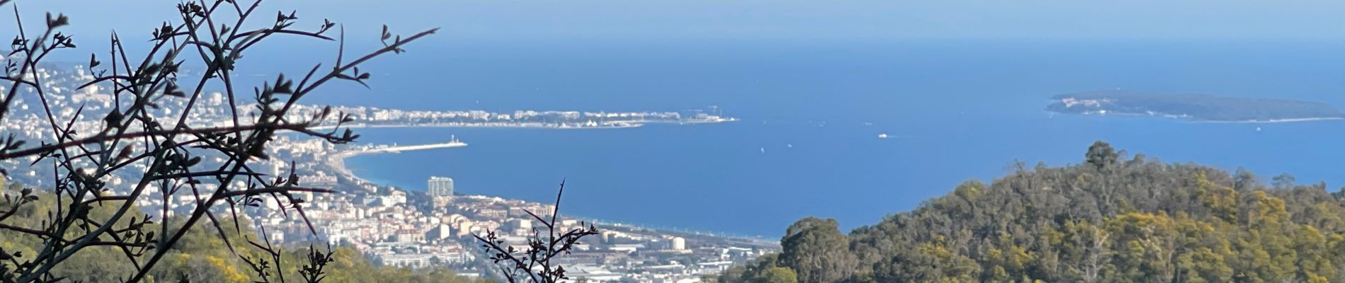
superbe randonnée plein de mimosas parcours varie