Trail Walking Auriac-du-Périgord - Auriac Azérat 16km - Photo
 YV24
YV24

User

© OpenStreetMap contributors
Length
Length
15.3 km
Max alt
Max alt
280 m
Uphill gradient
Uphill gradient
403 m
Km-Effort
Km-Effort  
21 km
Min alt
Min alt
118 m
Downhill gradient
Downhill gradient
403 m
Boucle
Boucle
Yes
Creation date :
2014-12-10 00:00:00.0
Updated on :
2014-12-10 00:00:00.0

(0 Reviews)

Walking
Walking
4h11
Difficulty : Easy

Scan this QR Code to open this trail in the SityTrail application

FREE GPS app for hiking

Logo SityTrail SityTrail

IGN / Geographical institutes

Download SityTrail from the App Store Download SityTrail from Google Play

Logo SityTrail SityTrail World

The world is yours!

Download SityTrail from the App Store Download SityTrail from Google Play Download SityTrail on Huawei AppGallery

About

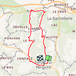
Trail Walking of 15.3 km to be discovered at New Aquitaine, Dordogne, Auriac-du-Périgord. This trail is proposed by YV24.

Description

Variante au départ d'Auriac, de la boucle sud d'Azérat. Balisage multiples. Variée, peu de route, bien tracée.

Elevation profile

Positioning

Country:
France
Region :
New Aquitaine
Department/Province :
Dordogne
Municipality :
Auriac-du-Périgord
Location:
Unknown
Start:(UTM)
353441 ; 4996382 (31T) N.

Trails nearby

Trail Walking Montignac-Lascaux - Balade Montignac Dordogne - Photo
Walking
FPortier

Walking

Easy
Montignac-Lascaux, New Aquitaine, Dordogne, France
3 km | 3.8 km-effort
1h 17min
Yes
Trail Walking Montignac-Lascaux - vezere_9 - Photo
Walking
fanthou

Walking

Medium
(1)
Montignac-Lascaux, New Aquitaine, Dordogne, France
13.5 km | 17.9 km-effort
3h 48min
Yes
Trail Walking Les Farges - vezere_6 - Photo
Walking
fanthou

Walking

Medium
(1)
Les Farges, New Aquitaine, Dordogne, France
8.7 km | 11.8 km-effort
2h 31min
Yes
Trail Walking Les Farges - vezere_5 - Photo
Walking
fanthou

Walking

Medium
(2)
Les Farges, New Aquitaine, Dordogne, France
7 km | 9.6 km-effort
2h 3min
Yes
Trail Mountain bike Thenon - Du Verdoyant à Saint Léon-sur-Vézère - Photo
Mountain bike
tracegps

Mountain bike

Difficult
Thenon, New Aquitaine, Dordogne, France
30 km | 40 km-effort
3h 0min
No
Trail Mountain bike Thenon - Du Verdoyant à St Orse avec la boucle du Boscornut -  Thenon - Photo
Mountain bike
tracegps

Mountain bike

Difficult
Thenon, New Aquitaine, Dordogne, France
35 km | 46 km-effort
3h 0min
No
Trail Walking Montignac-Lascaux - Montignac-peyzac - Photo
Walking
jenogues

Walking

Medium
Montignac-Lascaux, New Aquitaine, Dordogne, France
26 km | 36 km-effort
6h 57min
No
Trail Walking La Bachellerie - Boucle de la Bachellerie - Photo
Walking
CC.RIDER

Walking

Difficult
La Bachellerie, New Aquitaine, Dordogne, France
11.9 km | 15.8 km-effort
3h 35min
Yes
Trail Walking Aubas - Circuit des trois châteaux - Photo
Walking
CC.RIDER

Walking

Difficult
(2)
Aubas, New Aquitaine, Dordogne, France
13.7 km | 18.1 km-effort
4h 7min
Yes


Close
My subscriptions