![](/images/other/stat-length.png)
![Trail Snowshoes Entraunes - Tête de la Boucharde - Photo](https://media.geolcdn.com/t/1900/400/5d5c8bf3-90ea-4499-9e75-8d36ad4a26c7.jpg&format=pjpeg&maxdim=2)
Tête de la Boucharde
bozo1970
User
![Length](/images/other/stat-length.png)
![Max alt](https://static1.geolcdn.com/siteimages/upload/files/1508320355ic_sort_altitude_max_24dp.png)
![Uphill gradient](https://static1.geolcdn.com/siteimages/upload/files/1508320355ic_sort_den_pos_24dp.png)
![Km-Effort](/images/other/stat-length.png)
![Min alt](https://static1.geolcdn.com/siteimages/upload/files/1508320355ic_sort_altitude_min_24dp.png)
![Downhill gradient](https://static1.geolcdn.com/siteimages/upload/files/1508320355ic_sort_den_neg_24dp.png)
![Boucle](https://static1.geolcdn.com/siteimages/upload/files/16400158638029165_repeat_loop_refresh_sync_direction_icon.png)
![Snowshoes](https://static1.geolcdn.com/sitytour/trail-icons/504.png)
4h09
Difficulty : Medium
![Scan this QR Code to open this trail in the SityTrail application](https://capi.geolives.com/qq0zvz2zws4bq2lad0pu/sitytour/trails/3538284/qr.png?size=200)
FREE GPS app for hiking
About
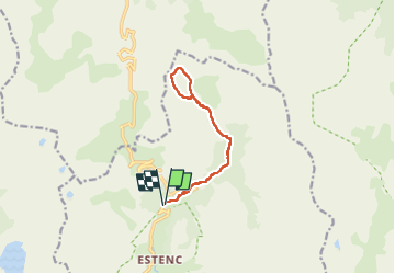
Trail Snowshoes of 10.9 km to be discovered at Provence-Alpes-Côte d'Azur, Maritime Alps, Entraunes. This trail is proposed by bozo1970.
Description
Montée par les cabanes de Sanguinière
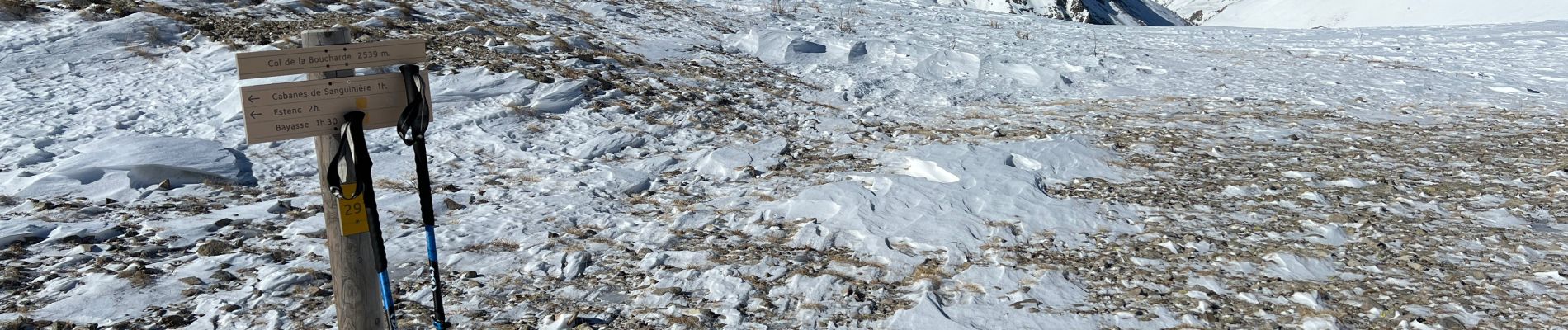
Ravin de la Boucharde
Col de la Boucharde en 2h28’, 5km550 et D 632m
Tête de la Boucharde en 2h45’’, 6km et D 741m
Vue fabuleuse sur le col de la petite Cayolle, le refuge de la Cayolle, la cîme de l’Eschillon, la tête de Sanguinière, le Sanguinerette et pointe côte de l’âne
Retour dans la pente et par le chemin de montée car il y a une zone protégée pour le grand Tétra !!
A/R en 4h09’ et 11km200
Positioning
Comments
Trails nearby
![Trail Walking Uvernet-Fours - Mercantour Le Cimet 3020 m - Photo](https://media.geolcdn.com/t/375/260/ext.jpg?maxdim=2&url=https%3A%2F%2Fservices.sitytrail.com%2FGeolivesWS%2FDownloadMedia.ashx%3FTrailID%3D224622%26Media%3D20130930134741.jpg)
![Walking Walking](https://static1.geolcdn.com/sitytour/trail-icons/101.png)
Walking
![](/images/other/stat-length.png)
![](https://static1.geolcdn.com/siteimages/upload/files/16400158638029165_repeat_loop_refresh_sync_direction_icon.png)
![Walking Walking](https://static1.geolcdn.com/sitytour/trail-icons/101.png)
Walking
![](/images/other/stat-length.png)
![](https://static1.geolcdn.com/siteimages/upload/files/16400158638029165_repeat_loop_refresh_sync_direction_icon.png)
![Trail Walking Allos - ALLOS. LAC D ALLOS. COL DE LACAYOLE .O - Photo](https://media.geolcdn.com/t/375/260/dff6c4e7-81d7-4f55-8309-f016e1c29cdc.jpg&format=jpg&maxdim=2)
![Walking Walking](https://static1.geolcdn.com/sitytour/trail-icons/101.png)
Walking
![](/images/other/stat-length.png)
![](https://static1.geolcdn.com/siteimages/upload/files/16400158638029165_repeat_loop_refresh_sync_direction_icon.png)
![Walking Walking](https://static1.geolcdn.com/sitytour/trail-icons/101.png)
Walking
![](/images/other/stat-length.png)
![](https://static1.geolcdn.com/siteimages/upload/files/16400158638029165_repeat_loop_refresh_sync_direction_icon.png)
![Trail On foot Entraunes - Circuit des Lacs - Photo](https://media.geolcdn.com/t/375/260/a896acce-5a5d-4d38-a76c-8521eb37107d.jpeg&format=jpg&maxdim=2)
![On foot On foot](https://static1.geolcdn.com/sitytour/trail-icons/100.png)
On foot
![](/images/other/stat-length.png)
![](https://static1.geolcdn.com/siteimages/upload/files/16400158638029165_repeat_loop_refresh_sync_direction_icon.png)
![Trail On foot Entraunes - Col de la Boucharde - Photo](https://media.geolcdn.com/t/375/260/3f8fb4f1-6b5f-4291-a48f-766ff65dc022.jpeg&format=jpg&maxdim=2)
![On foot On foot](https://static1.geolcdn.com/sitytour/trail-icons/100.png)
On foot
![](/images/other/stat-length.png)
![](https://static1.geolcdn.com/siteimages/upload/files/16400158638029165_repeat_loop_refresh_sync_direction_icon.png)
![Trail On foot Entraunes - Tête de la Boulière - Photo](https://media.geolcdn.com/t/375/260/4b7ce69a-b9c1-4af6-a119-2b6bf9e9add8.jpeg&format=jpg&maxdim=2)
![On foot On foot](https://static1.geolcdn.com/sitytour/trail-icons/100.png)
On foot
![](/images/other/stat-length.png)
![](https://static1.geolcdn.com/siteimages/upload/files/16400158638029165_repeat_loop_refresh_sync_direction_icon.png)
![Trail Walking Allos - le mont Pelat et le lac du trou de l'aigle - Photo](https://media.geolcdn.com/t/375/260/ext.jpg?maxdim=2&url=https%3A%2F%2Fservices.sitytrail.com%2FGeolivesWS%2FDownloadMedia.ashx%3FTrailID%3D791325%26Media%3D36a05fdf-444e-4dea-af98-fa2a609b54f1.JPG)
![Walking Walking](https://static1.geolcdn.com/sitytour/trail-icons/101.png)
Walking
![](/images/other/stat-length.png)
![](https://static1.geolcdn.com/siteimages/upload/files/16400158638029165_repeat_loop_refresh_sync_direction_icon.png)
![Trail On foot Uvernet-Fours - Circuit des lacs, 04-09-2024 - Photo](https://media.geolcdn.com/t/375/260/09012fd6-d42d-4279-856d-5992e350195b.jpg&format=jpg&maxdim=2)
![On foot On foot](https://static1.geolcdn.com/sitytour/trail-icons/100.png)
On foot
![](/images/other/stat-length.png)
![](https://static1.geolcdn.com/siteimages/upload/files/16400158638029165_repeat_loop_refresh_sync_direction_icon.png)