![](/images/other/stat-length.png)
![Trail Walking Ramatuelle - Escalet MM - Photo](https://media.geolcdn.com/t/1900/400/1cd19229-47f7-4c20-81f6-c529949f95ae.jpg&format=pjpeg&maxdim=2)
Escalet MM
ETMU5496
User
![Length](/images/other/stat-length.png)
Length
14.9 km
![Max alt](https://static1.geolcdn.com/siteimages/upload/files/1508320355ic_sort_altitude_max_24dp.png)
Max alt
142 m
![Uphill gradient](https://static1.geolcdn.com/siteimages/upload/files/1508320355ic_sort_den_pos_24dp.png)
Uphill gradient
391 m
![Km-Effort](/images/other/stat-length.png)
Km-Effort
20 km
![Min alt](https://static1.geolcdn.com/siteimages/upload/files/1508320355ic_sort_altitude_min_24dp.png)
Min alt
0 m
![Downhill gradient](https://static1.geolcdn.com/siteimages/upload/files/1508320355ic_sort_den_neg_24dp.png)
Downhill gradient
390 m
![Boucle](https://static1.geolcdn.com/siteimages/upload/files/16400158638029165_repeat_loop_refresh_sync_direction_icon.png)
Boucle
Yes
Creation date :
2023-02-01 08:48:21.0
Updated on :
2023-02-01 18:42:29.177
![Walking](https://static1.geolcdn.com/sitytour/trail-icons/101.png)
4h48
Difficulty : Medium
![Scan this QR Code to open this trail in the SityTrail application](https://capi.geolives.com/qq0zvz2zws4bq2lad0pu/sitytour/trails/3537433/qr.png?size=200)
FREE GPS app for hiking
About
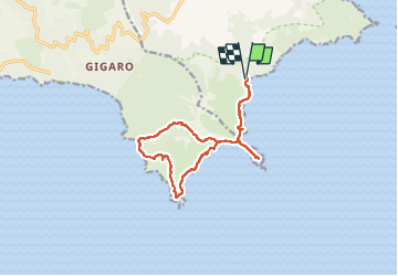
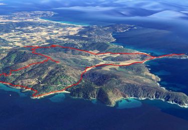
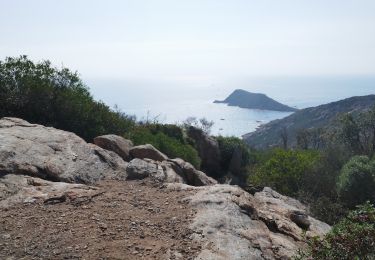
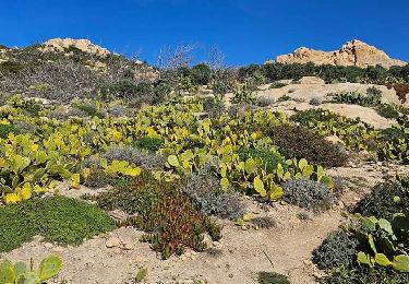
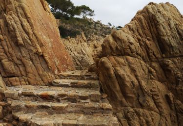
Trail Walking of 14.9 km to be discovered at Provence-Alpes-Côte d'Azur, Var, Ramatuelle. This trail is proposed by ETMU5496.
Description
départ plage de l'Escalet
boucle intégrant Cap Taillat, plage de Brouis Cap Lardier et A/R sur le Cap Taillat. Puis retour plage Escalet.
Qqes passages techniques mais très agréable randonnée sur le sentier du littoral.
Positioning
Country:
France
Region :
Provence-Alpes-Côte d'Azur
Department/Province :
Var
Municipality :
Ramatuelle
Location:
Unknown
Start:(Dec)
Start:(UTM)
308354 ; 4784289 (32T) N.
Comments
Trails nearby
![Trail On foot La Croix-Valmer - La Croix Valmer - Gigaro - Taillat - Collebasse - Gigaro - Photo](https://media.geolcdn.com/t/375/260/a03cc7dc-d40c-427d-bc15-d4c3c8fead2d.jpg&format=jpg&maxdim=2)
![On foot On foot](https://static1.geolcdn.com/sitytour/trail-icons/100.png)
La Croix Valmer - Gigaro - Taillat - Collebasse - Gigaro
On foot
Medium
(1)
La Croix-Valmer,
Provence-Alpes-Côte d'Azur,
Var,
France
![](/images/other/stat-length.png)
15.2 km | 20 km-effort
6h 0min
![](https://static1.geolcdn.com/siteimages/upload/files/16400158638029165_repeat_loop_refresh_sync_direction_icon.png)
Yes
![Trail Electric bike La Croix-Valmer - Rayol -Oppidum version 2 - Photo](https://media.geolcdn.com/t/375/260/fc5cd018-661e-4f17-bef8-76baca0d8415.jpg&format=jpg&maxdim=2)
![Electric bike Electric bike](https://static1.geolcdn.com/sitytour/trail-icons/205.png)
Rayol -Oppidum version 2
Electric bike
(1)
La Croix-Valmer,
Provence-Alpes-Côte d'Azur,
Var,
France
![](/images/other/stat-length.png)
40 km | 52 km-effort
2h 55min
![](https://static1.geolcdn.com/siteimages/upload/files/16400158638029165_repeat_loop_refresh_sync_direction_icon.png)
Yes
![Trail Electric bike La Croix-Valmer - Rayol -Oppidum - Photo](https://media.geolcdn.com/t/375/260/fc5cd018-661e-4f17-bef8-76baca0d8415.jpg&format=jpg&maxdim=2)
![Electric bike Electric bike](https://static1.geolcdn.com/sitytour/trail-icons/205.png)
Rayol -Oppidum
Electric bike
(1)
La Croix-Valmer,
Provence-Alpes-Côte d'Azur,
Var,
France
![](/images/other/stat-length.png)
40 km | 53 km-effort
2h 55min
![](https://static1.geolcdn.com/siteimages/upload/files/16400158638029165_repeat_loop_refresh_sync_direction_icon.png)
Yes
![Trail Walking Ramatuelle - Le cap Camarat - Photo](https://media.geolcdn.com/t/375/260/ext.jpg?maxdim=2&url=https%3A%2F%2Fservices.sitytrail.com%2FGeolivesWS%2FDownloadMedia.ashx%3FTrailID%3D787295%26Media%3D869e75b8-d08c-458a-b38d-0a864e88844b.JPG)
![Walking Walking](https://static1.geolcdn.com/sitytour/trail-icons/101.png)
Le cap Camarat
Walking
Medium
(1)
Ramatuelle,
Provence-Alpes-Côte d'Azur,
Var,
France
![](/images/other/stat-length.png)
6.8 km | 8.6 km-effort
1h 58min
![](https://static1.geolcdn.com/siteimages/upload/files/16400158638029165_repeat_loop_refresh_sync_direction_icon.png)
Yes
![Trail Mountain bike Ramatuelle - Ramatuelle moulins de Paillas et Patapans.gpx - Photo](https://media.geolcdn.com/t/375/260/ext.jpg?maxdim=2&url=https%3A%2F%2Fstatic1.geolcdn.com%2Fsiteimages%2Fupload%2Ffiles%2F1524743154velo.jpg)
![Mountain bike Mountain bike](https://static1.geolcdn.com/sitytour/trail-icons/202.png)
Ramatuelle moulins de Paillas et Patapans.gpx
Mountain bike
Medium
(1)
Ramatuelle,
Provence-Alpes-Côte d'Azur,
Var,
France
![](/images/other/stat-length.png)
19.8 km | 26 km-effort
2h 22min
![](https://static1.geolcdn.com/siteimages/upload/files/16400158638029165_repeat_loop_refresh_sync_direction_icon.png)
No
![Trail Walking La Croix-Valmer - Cap Lardier - Photo](https://media.geolcdn.com/t/375/260/ext.jpg?maxdim=2&url=https%3A%2F%2Fstatic1.geolcdn.com%2Fsiteimages%2Fupload%2Ffiles%2F1553511878bg_sport_marche.png)
![Walking Walking](https://static1.geolcdn.com/sitytour/trail-icons/101.png)
Cap Lardier
Walking
Medium
(1)
La Croix-Valmer,
Provence-Alpes-Côte d'Azur,
Var,
France
![](/images/other/stat-length.png)
14 km | 18.9 km-effort
4h 8min
![](https://static1.geolcdn.com/siteimages/upload/files/16400158638029165_repeat_loop_refresh_sync_direction_icon.png)
Yes
![Trail Walking Ramatuelle - Cap Taillat - Photo](https://media.geolcdn.com/t/375/260/c19e1d17-4219-4145-aa57-37ef6d706476.jpg&format=jpg&maxdim=2)
![Walking Walking](https://static1.geolcdn.com/sitytour/trail-icons/101.png)
Cap Taillat
Walking
Medium
Ramatuelle,
Provence-Alpes-Côte d'Azur,
Var,
France
![](/images/other/stat-length.png)
7.4 km | 9.7 km-effort
2h 12min
![](https://static1.geolcdn.com/siteimages/upload/files/16400158638029165_repeat_loop_refresh_sync_direction_icon.png)
Yes
![Trail Walking La Croix-Valmer - GIGARO . cap Taillat. AB -1 - Photo](https://media.geolcdn.com/t/375/260/816705b7-121a-4690-b7dd-3111fd3ff4d3.jpg&format=jpg&maxdim=2)
![Walking Walking](https://static1.geolcdn.com/sitytour/trail-icons/101.png)
GIGARO . cap Taillat. AB -1
Walking
Difficult
La Croix-Valmer,
Provence-Alpes-Côte d'Azur,
Var,
France
![](/images/other/stat-length.png)
16.5 km | 22 km-effort
4h 43min
![](https://static1.geolcdn.com/siteimages/upload/files/16400158638029165_repeat_loop_refresh_sync_direction_icon.png)
Yes
![Trail Walking Ramatuelle - Cap Camarat - Photo](https://media.geolcdn.com/t/375/260/3ece29cc-b215-4df0-ac82-e0f419310b1a.jpg&format=jpg&maxdim=2)
![Walking Walking](https://static1.geolcdn.com/sitytour/trail-icons/101.png)
Cap Camarat
Walking
Easy
Ramatuelle,
Provence-Alpes-Côte d'Azur,
Var,
France
![](/images/other/stat-length.png)
8.5 km | 11.4 km-effort
5h 30min
![](https://static1.geolcdn.com/siteimages/upload/files/16400158638029165_repeat_loop_refresh_sync_direction_icon.png)
Yes