![](/images/other/stat-length.png)
![Trail Walking Solliès-Pont - la croix de la navarre - Photo](https://media.geolcdn.com/t/1900/400/150db195-fba5-499e-b3ba-2996f9257c9e.jpg&format=pjpeg&maxdim=2)
la croix de la navarre
cdanielrando
User
![Length](/images/other/stat-length.png)
Length
16.5 km
![Max alt](https://static1.geolcdn.com/siteimages/upload/files/1508320355ic_sort_altitude_max_24dp.png)
Max alt
265 m
![Uphill gradient](https://static1.geolcdn.com/siteimages/upload/files/1508320355ic_sort_den_pos_24dp.png)
Uphill gradient
577 m
![Km-Effort](/images/other/stat-length.png)
Km-Effort
24 km
![Min alt](https://static1.geolcdn.com/siteimages/upload/files/1508320355ic_sort_altitude_min_24dp.png)
Min alt
46 m
![Downhill gradient](https://static1.geolcdn.com/siteimages/upload/files/1508320355ic_sort_den_neg_24dp.png)
Downhill gradient
577 m
![Boucle](https://static1.geolcdn.com/siteimages/upload/files/16400158638029165_repeat_loop_refresh_sync_direction_icon.png)
Boucle
Yes
Creation date :
2023-01-29 13:57:34.695
Updated on :
2023-02-10 08:36:26.115
![Walking](https://static1.geolcdn.com/sitytour/trail-icons/101.png)
5h30
Difficulty : Very difficult
![Scan this QR Code to open this trail in the SityTrail application](https://capi.geolives.com/qq0zvz2zws4bq2lad0pu/sitytour/trails/3533643/qr.png?size=200)
FREE GPS app for hiking
About
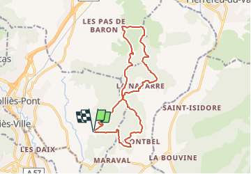
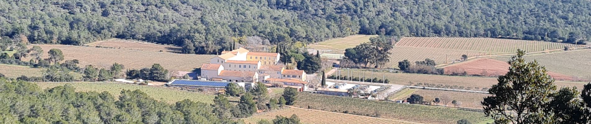
Trail Walking of 16.5 km to be discovered at Provence-Alpes-Côte d'Azur, Var, Solliès-Pont. This trail is proposed by cdanielrando.
Description
Beau circuit sans aucune difficulté si ne n'est sa longueur.
Le départ et l'arrivée sont au parking du collège la Navarre.
Marcher de préférence dans le sens inverse des aiguilles d'une montre pour bien profiter du paysage.
Positioning
Country:
France
Region :
Provence-Alpes-Côte d'Azur
Department/Province :
Var
Municipality :
Solliès-Pont
Location:
Unknown
Start:(Dec)
Start:(UTM)
262746 ; 4784874 (32T) N.
Comments
Trails nearby
![Trail Walking La Crau - fenouillet Daniel Louis - Photo](https://media.geolcdn.com/t/375/260/74a8e577-0c5f-4f83-9925-bb595eab64a1.jpg&format=jpg&maxdim=2)
![Walking Walking](https://static1.geolcdn.com/sitytour/trail-icons/101.png)
fenouillet Daniel Louis
Walking
Medium
(1)
La Crau,
Provence-Alpes-Côte d'Azur,
Var,
France
![](/images/other/stat-length.png)
18.1 km | 25 km-effort
4h 36min
![](https://static1.geolcdn.com/siteimages/upload/files/16400158638029165_repeat_loop_refresh_sync_direction_icon.png)
Yes
![Trail Walking La Crau - le fenouillet un après-midi d'automne - Photo](https://media.geolcdn.com/t/375/260/ext.jpg?maxdim=2&url=https%3A%2F%2Fservices.sitytrail.com%2FGeolivesWS%2FDownloadMedia.ashx%3FTrailID%3D650501%26Media%3D20161024161101.jpg)
![Walking Walking](https://static1.geolcdn.com/sitytour/trail-icons/101.png)
le fenouillet un après-midi d'automne
Walking
Easy
(2)
La Crau,
Provence-Alpes-Côte d'Azur,
Var,
France
![](/images/other/stat-length.png)
7.6 km | 10.7 km-effort
1h 48min
![](https://static1.geolcdn.com/siteimages/upload/files/16400158638029165_repeat_loop_refresh_sync_direction_icon.png)
Yes
![Trail Trail Solliès-Pont - Mont Goudon boucle - Photo](https://media.geolcdn.com/t/375/260/c2cc87c3-0b5e-469f-91a1-61249a1514ac.jpg&format=jpg&maxdim=2)
![Trail Trail](https://static1.geolcdn.com/sitytour/trail-icons/104.png)
Mont Goudon boucle
Trail
Difficult
Solliès-Pont,
Provence-Alpes-Côte d'Azur,
Var,
France
![](/images/other/stat-length.png)
28 km | 43 km-effort
4h 35min
![](https://static1.geolcdn.com/siteimages/upload/files/16400158638029165_repeat_loop_refresh_sync_direction_icon.png)
Yes
![Trail Trail Solliès-Pont - Le Coudon - Photo](https://media.geolcdn.com/t/375/260/abb8f2fd-c3f3-40be-97f6-8c7a30b446a6.jpg&format=jpg&maxdim=2)
![Trail Trail](https://static1.geolcdn.com/sitytour/trail-icons/104.png)
Le Coudon
Trail
Difficult
Solliès-Pont,
Provence-Alpes-Côte d'Azur,
Var,
France
![](/images/other/stat-length.png)
22 km | 35 km-effort
3h 30min
![](https://static1.geolcdn.com/siteimages/upload/files/16400158638029165_repeat_loop_refresh_sync_direction_icon.png)
Yes
![Trail Trail La Crau - Le Fenouillet et château d' Hyères - Photo](https://media.geolcdn.com/t/375/260/b5c97bc5-16a4-4fca-8ec6-5ff57c47ff40.jpg&format=jpg&maxdim=2)
![Trail Trail](https://static1.geolcdn.com/sitytour/trail-icons/104.png)
Le Fenouillet et château d' Hyères
Trail
Medium
La Crau,
Provence-Alpes-Côte d'Azur,
Var,
France
![](/images/other/stat-length.png)
13.1 km | 18.8 km-effort
2h 9min
![](https://static1.geolcdn.com/siteimages/upload/files/16400158638029165_repeat_loop_refresh_sync_direction_icon.png)
No
![Trail Walking La Crau - Fenouillet - Chateau de Hyères - retour par les vignes - Photo](https://media.geolcdn.com/t/375/260/d2132167-a625-4ff2-ae44-a142bdaeb4e4.jpg&format=jpg&maxdim=2)
![Walking Walking](https://static1.geolcdn.com/sitytour/trail-icons/101.png)
Fenouillet - Chateau de Hyères - retour par les vignes
Walking
Medium
(2)
La Crau,
Provence-Alpes-Côte d'Azur,
Var,
France
![](/images/other/stat-length.png)
14.1 km | 19.7 km-effort
5h 0min
![](https://static1.geolcdn.com/siteimages/upload/files/16400158638029165_repeat_loop_refresh_sync_direction_icon.png)
Yes
![Trail Walking La Farlède - La farlède-plateau de Mourras-Sollies ville-La farlède - Photo](https://media.geolcdn.com/t/375/260/a84fbeac-69b5-4bc6-a51e-04fa1dab410e.jpg&format=jpg&maxdim=2)
![Walking Walking](https://static1.geolcdn.com/sitytour/trail-icons/101.png)
La farlède-plateau de Mourras-Sollies ville-La farlède
Walking
Very difficult
La Farlède,
Provence-Alpes-Côte d'Azur,
Var,
France
![](/images/other/stat-length.png)
21 km | 31 km-effort
7h 41min
![](https://static1.geolcdn.com/siteimages/upload/files/16400158638029165_repeat_loop_refresh_sync_direction_icon.png)
Yes
![Trail Walking La Farlède - Petit Coudon en partant de La Farlède - Photo](https://media.geolcdn.com/t/375/260/3e008989-684c-402b-9f5c-2d8e6fd0c68a.jpg&format=jpg&maxdim=2)
![Walking Walking](https://static1.geolcdn.com/sitytour/trail-icons/101.png)
Petit Coudon en partant de La Farlède
Walking
Difficult
La Farlède,
Provence-Alpes-Côte d'Azur,
Var,
France
![](/images/other/stat-length.png)
10.9 km | 16.1 km-effort
5h 18min
![](https://static1.geolcdn.com/siteimages/upload/files/16400158638029165_repeat_loop_refresh_sync_direction_icon.png)
Yes
![Trail Walking La Farlède - De La farlède vers le sommet du Mont Coudon, puis retour par le petit Coudon - Photo](https://media.geolcdn.com/t/375/260/9085658d-5eb9-4632-896f-873f8f366eb4.jpg&format=jpg&maxdim=2)
![Walking Walking](https://static1.geolcdn.com/sitytour/trail-icons/101.png)
De La farlède vers le sommet du Mont Coudon, puis retour par le petit Coudon
Walking
Very difficult
La Farlède,
Provence-Alpes-Côte d'Azur,
Var,
France
![](/images/other/stat-length.png)
14.1 km | 22 km-effort
6h 55min
![](https://static1.geolcdn.com/siteimages/upload/files/16400158638029165_repeat_loop_refresh_sync_direction_icon.png)
Yes