![](/images/other/stat-length.png)
![Trail Walking Montmirail - MONTMIRAIL La randonnée des remparts - Photo](https://media.geolcdn.com/t/1900/400/ext.pjpeg?maxdim=2&url=https%3A%2F%2Fstatic1.geolcdn.com%2Fsiteimages%2Fupload%2Ffiles%2F1553511878bg_sport_marche.png)
MONTMIRAIL La randonnée des remparts
quatre sans cinq
User
![Length](/images/other/stat-length.png)
![Max alt](https://static1.geolcdn.com/siteimages/upload/files/1508320355ic_sort_altitude_max_24dp.png)
![Uphill gradient](https://static1.geolcdn.com/siteimages/upload/files/1508320355ic_sort_den_pos_24dp.png)
![Km-Effort](/images/other/stat-length.png)
![Min alt](https://static1.geolcdn.com/siteimages/upload/files/1508320355ic_sort_altitude_min_24dp.png)
![Downhill gradient](https://static1.geolcdn.com/siteimages/upload/files/1508320355ic_sort_den_neg_24dp.png)
![Boucle](https://static1.geolcdn.com/siteimages/upload/files/16400158638029165_repeat_loop_refresh_sync_direction_icon.png)
![Walking](https://static1.geolcdn.com/sitytour/trail-icons/101.png)
1h10
Difficulty : Easy
![Scan this QR Code to open this trail in the SityTrail application](https://capi.geolives.com/qq0zvz2zws4bq2lad0pu/sitytour/trails/3531191/qr.png?size=200)
FREE GPS app for hiking
About
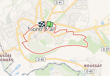
Trail Walking of 4.1 km to be discovered at Grand Est, Marne, Montmirail. This trail is proposed by quatre sans cinq.
Description
Ce circuit, au départ de l'Office de tourisme emprunte les ruelles et l'ancienne voie ferrée. Dans la ruelle des Remparts subsiste la base des tours et des murailles. Les fossés sont utilisés en jardin public d'agrément ou en jardin privé. L'ancienne voie ferrée est devenue une promenade agréable dotée d'un parcours de santé. Le Chateau de Montmirail, ouvert du lundi au jeudi, les mois d'été, est un édifice du XVIIème siècle, dont les jardins "à la française" furent dessinés par Le Nôtre.
Positioning
Comments
Trails nearby
![Trail Walking Montmirail - Montmirail du 22-09-2022 - Photo](https://media.geolcdn.com/t/375/260/4ad44a7b-b384-4917-a2eb-f2a79f2e2c2b.jpg&format=jpg&maxdim=2)
![Walking Walking](https://static1.geolcdn.com/sitytour/trail-icons/101.png)
Walking
![](/images/other/stat-length.png)
![](https://static1.geolcdn.com/siteimages/upload/files/16400158638029165_repeat_loop_refresh_sync_direction_icon.png)
![Trail Walking Montmirail - Montmirail du 28/08/2022 - Photo](https://media.geolcdn.com/t/375/260/bb7755e4-4ba5-4b80-8a7a-c2c4fc72339c.jpg&format=jpg&maxdim=2)
![Walking Walking](https://static1.geolcdn.com/sitytour/trail-icons/101.png)
Walking
![](/images/other/stat-length.png)
![](https://static1.geolcdn.com/siteimages/upload/files/16400158638029165_repeat_loop_refresh_sync_direction_icon.png)
![Trail Walking Dhuys et Morin-en-Brie - Marchais En Brie - Photo](https://media.geolcdn.com/t/375/260/ext.jpg?maxdim=2&url=https%3A%2F%2Fstatic1.geolcdn.com%2Fsiteimages%2Fupload%2Ffiles%2F1553511878bg_sport_marche.png)
![Walking Walking](https://static1.geolcdn.com/sitytour/trail-icons/101.png)
Walking
![](/images/other/stat-length.png)
![](https://static1.geolcdn.com/siteimages/upload/files/16400158638029165_repeat_loop_refresh_sync_direction_icon.png)
![Trail Walking Montmirail - Montmirail - Photo](https://media.geolcdn.com/t/375/260/ext.jpg?maxdim=2&url=https%3A%2F%2Fstatic1.geolcdn.com%2Fsiteimages%2Fupload%2Ffiles%2F1553511878bg_sport_marche.png)
![Walking Walking](https://static1.geolcdn.com/sitytour/trail-icons/101.png)