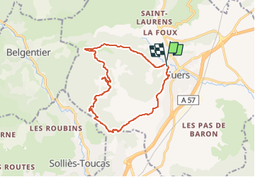
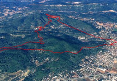
![](/images/other/stat-length.png)
![Trail Walking Cuers - valcros ste christine - Photo](https://media.geolcdn.com/t/1900/400/67c16a7c-08b4-45b7-8bdf-43004381fa9e.jpg&format=pjpeg&maxdim=2)
valcros ste christine
cdanielrando
User
![Length](/images/other/stat-length.png)
![Max alt](https://static1.geolcdn.com/siteimages/upload/files/1508320355ic_sort_altitude_max_24dp.png)
![Uphill gradient](https://static1.geolcdn.com/siteimages/upload/files/1508320355ic_sort_den_pos_24dp.png)
![Km-Effort](/images/other/stat-length.png)
![Min alt](https://static1.geolcdn.com/siteimages/upload/files/1508320355ic_sort_altitude_min_24dp.png)
![Downhill gradient](https://static1.geolcdn.com/siteimages/upload/files/1508320355ic_sort_den_neg_24dp.png)
![Boucle](https://static1.geolcdn.com/siteimages/upload/files/16400158638029165_repeat_loop_refresh_sync_direction_icon.png)
![Walking](https://static1.geolcdn.com/sitytour/trail-icons/101.png)
5h21
Difficulty : Very difficult
![Scan this QR Code to open this trail in the SityTrail application](https://capi.geolives.com/qq0zvz2zws4bq2lad0pu/sitytour/trails/3530430/qr.png?size=200)
FREE GPS app for hiking
About
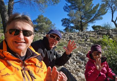
Trail Walking of 15.2 km to be discovered at Provence-Alpes-Côte d'Azur, Var, Cuers. This trail is proposed by cdanielrando.
Description
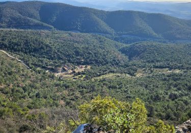
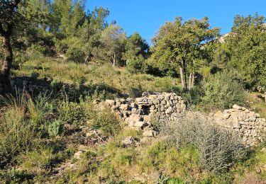
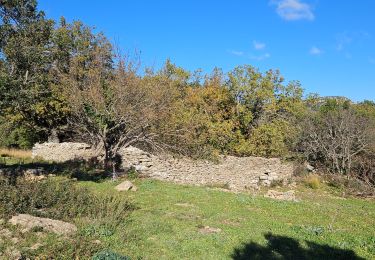
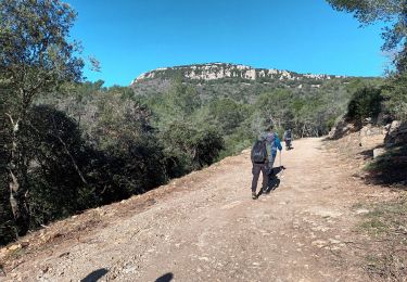
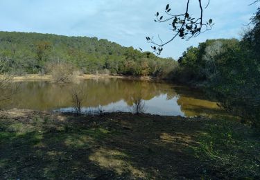
Après l'aqueduc des 5 ponts, quitter la route à droite pour monter sur la crête des hautes Sambalettes Rejoindre le hameau de Valcros par l'ubac de capus et le mari pays. dans le hameau, voir l'arbre de la liberté et le four à pain ainsi que l'ancienne chapelle. Du belvédère des 2 chapelles Ste Christine la vue est spectaculaire. De cet endroit, rejoindre N D de santé qui domine le village de Cuers par un beau sentier en balcon.
Positioning
Comments
Trails nearby
![Trail Mountain bike Rocbaron - La Chapelle Sainte-Philomène - Rocbaron - Photo](https://media.geolcdn.com/t/375/260/ext.jpg?maxdim=2&url=https%3A%2F%2Fservices.sitytrail.com%2FGeolivesWS%2FDownloadMedia.ashx%3FTrailID%3D173149%26Media%3D14715_4.jpg)
![Mountain bike Mountain bike](https://static1.geolcdn.com/sitytour/trail-icons/202.png)
Mountain bike
![](/images/other/stat-length.png)
![](https://static1.geolcdn.com/siteimages/upload/files/16400158638029165_repeat_loop_refresh_sync_direction_icon.png)
![Trail Walking Cuers - la foux cuers opidum - Photo](https://media.geolcdn.com/t/375/260/ext.jpg?maxdim=2&url=https%3A%2F%2Fservices.sitytrail.com%2FGeolivesWS%2FDownloadMedia.ashx%3FTrailID%3D518258%26Media%3Dfix__20160127150117.jpg)
![Walking Walking](https://static1.geolcdn.com/sitytour/trail-icons/101.png)
Walking
![](/images/other/stat-length.png)
![](https://static1.geolcdn.com/siteimages/upload/files/16400158638029165_repeat_loop_refresh_sync_direction_icon.png)
![Trail Walking Cuers - Pilon Saint Clément - Photo](https://media.geolcdn.com/t/375/260/127c8d12-3441-42a6-b036-f1c61808aeac.jpg&format=jpg&maxdim=2)
![Walking Walking](https://static1.geolcdn.com/sitytour/trail-icons/101.png)
Walking
![](/images/other/stat-length.png)
![](https://static1.geolcdn.com/siteimages/upload/files/16400158638029165_repeat_loop_refresh_sync_direction_icon.png)
![Trail Walking Cuers - Du col de la bigue vers le bas des barres de Cuers - Photo](https://media.geolcdn.com/t/375/260/4deb610c-bf41-4af0-baa2-7e7e353ac8a9.jpg&format=jpg&maxdim=2)
![Walking Walking](https://static1.geolcdn.com/sitytour/trail-icons/101.png)
Walking
![](/images/other/stat-length.png)
![](https://static1.geolcdn.com/siteimages/upload/files/16400158638029165_repeat_loop_refresh_sync_direction_icon.png)
![Trail Walking Cuers - Sous les barres de Cuers en partant de La Foux - Photo](https://media.geolcdn.com/t/375/260/ddaffc22-d3b7-42da-aa7d-3b1cd8482841.jpg&format=jpg&maxdim=2)
![Walking Walking](https://static1.geolcdn.com/sitytour/trail-icons/101.png)
Walking
![](/images/other/stat-length.png)
![](https://static1.geolcdn.com/siteimages/upload/files/16400158638029165_repeat_loop_refresh_sync_direction_icon.png)
![Trail Walking Cuers - Promenade sous les barres de Cuers, en partant du village de Cuers - Photo](https://media.geolcdn.com/t/375/260/763db821-3faf-41c8-99d4-ebbc220e66cf.jpg&format=jpg&maxdim=2)
![Walking Walking](https://static1.geolcdn.com/sitytour/trail-icons/101.png)
Walking
![](/images/other/stat-length.png)
![](https://static1.geolcdn.com/siteimages/upload/files/16400158638029165_repeat_loop_refresh_sync_direction_icon.png)
![Trail Walking Cuers - pilon St Clément-06-03-2024 - Photo](https://media.geolcdn.com/t/375/260/09d4d944-939e-4591-ae88-1b9547cd46a5.jpg&format=jpg&maxdim=2)
![Walking Walking](https://static1.geolcdn.com/sitytour/trail-icons/101.png)
Walking
![](/images/other/stat-length.png)
![](https://static1.geolcdn.com/siteimages/upload/files/16400158638029165_repeat_loop_refresh_sync_direction_icon.png)
![Trail Walking Solliès-Pont - Lac de Montbel - Photo](https://media.geolcdn.com/t/375/260/6fc5c56f-f92a-41ee-8ff6-d281a9a6dd5e.jpg&format=jpg&maxdim=2)
![Walking Walking](https://static1.geolcdn.com/sitytour/trail-icons/101.png)
Walking
![](/images/other/stat-length.png)
![](https://static1.geolcdn.com/siteimages/upload/files/16400158638029165_repeat_loop_refresh_sync_direction_icon.png)
![Trail Walking Cuers - 2021-04-10_15h53m44_apie de sambalettes a partir de st christine - Photo](https://media.geolcdn.com/t/375/260/f29abdba-3003-4fbf-abdb-d2a62579cd65.jpg&format=jpg&maxdim=2)
![Walking Walking](https://static1.geolcdn.com/sitytour/trail-icons/101.png)
Walking
![](/images/other/stat-length.png)
![](https://static1.geolcdn.com/siteimages/upload/files/16400158638029165_repeat_loop_refresh_sync_direction_icon.png)