![](/images/other/stat-length.png)
![Trail Walking Terre-de-Bancalié - 2023-01-25_07h53m46_Cirkwi-Chemin_Des_Mineurs - Photo](https://media.geolcdn.com/t/1900/400/ext.pjpeg?maxdim=2&url=https%3A%2F%2Fstatic1.geolcdn.com%2Fsiteimages%2Fupload%2Ffiles%2F1553511878bg_sport_marche.png)
2023-01-25_07h53m46_Cirkwi-Chemin_Des_Mineurs
tercla
User
![Length](/images/other/stat-length.png)
![Max alt](https://static1.geolcdn.com/siteimages/upload/files/1508320355ic_sort_altitude_max_24dp.png)
![Uphill gradient](https://static1.geolcdn.com/siteimages/upload/files/1508320355ic_sort_den_pos_24dp.png)
![Km-Effort](/images/other/stat-length.png)
![Min alt](https://static1.geolcdn.com/siteimages/upload/files/1508320355ic_sort_altitude_min_24dp.png)
![Downhill gradient](https://static1.geolcdn.com/siteimages/upload/files/1508320355ic_sort_den_neg_24dp.png)
![Boucle](https://static1.geolcdn.com/siteimages/upload/files/16400158638029165_repeat_loop_refresh_sync_direction_icon.png)
![Walking](https://static1.geolcdn.com/sitytour/trail-icons/101.png)
3h11
Difficulty : Difficult
![Scan this QR Code to open this trail in the SityTrail application](https://capi.geolives.com/qq0zvz2zws4bq2lad0pu/sitytour/trails/3529390/qr.png?size=200)
FREE GPS app for hiking
About
Trail Walking of 10.4 km to be discovered at Occitania, Tarn, Terre-de-Bancalié. This trail is proposed by tercla.
Description
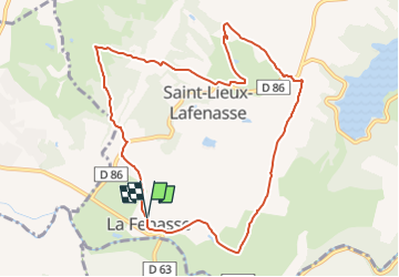
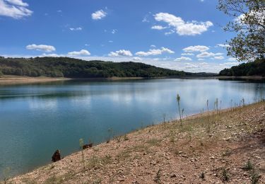
Boucle de 10,5 km sur les pas des mineurs qui partaient sacoche à l'épaule à travers bois et prairies pour rejoindre la mine de Peyrebrune. Départ de la place du villageLe chemin des Mineurs débute au sein même du bourg de Lafenasse. Il passe par des vallons creusés par le Siez, et remonte sur le plateau de Saint Lieux où le paysage se dégage sur les collines alentours, le regard porte jusqu'à la « Croix du Caylou » à Réalmont. Ce chemin, trait d'union entre deux villages (Saint Lieux et Lafenasse) est présent dans la mémoire collective des habitants, car autrefois utilisé par les mineurs, sacoche à la main, pour rejoindre la mine de plomb argentifère et de Zinc de « Peyrebrune ». Elle fut fermée en 1972.
Positioning
Comments
Trails nearby
![Trail Walking Terre-de-Bancalié - 81_Saint Lieux Lafenasse - Photo](https://media.geolcdn.com/t/375/260/ext.jpg?maxdim=2&url=https%3A%2F%2Fstatic1.geolcdn.com%2Fsiteimages%2Fupload%2Ffiles%2F1553511878bg_sport_marche.png)
![Walking Walking](https://static1.geolcdn.com/sitytour/trail-icons/101.png)
Walking
![](/images/other/stat-length.png)
![](https://static1.geolcdn.com/siteimages/upload/files/16400158638029165_repeat_loop_refresh_sync_direction_icon.png)
![Trail Moto cross Réalmont - Rando Monts de Lacaune, Laouzas, montagne noire. - Photo](https://media.geolcdn.com/t/375/260/11fc1da8-59d3-4b05-9dbc-670b2f23e8e6.jpg&format=jpg&maxdim=2)
![Moto cross Moto cross](https://static1.geolcdn.com/sitytour/trail-icons/406.png)
Moto cross
![](/images/other/stat-length.png)
![](https://static1.geolcdn.com/siteimages/upload/files/16400158638029165_repeat_loop_refresh_sync_direction_icon.png)
![Trail Moto cross Réalmont - Roquecourbe, Pic de nore, Minerve - Photo](https://media.geolcdn.com/t/375/260/e70284d5-3329-4fb7-a41a-d11af4aac54b.jpg&format=jpg&maxdim=2)
![Moto cross Moto cross](https://static1.geolcdn.com/sitytour/trail-icons/406.png)
Moto cross
![](/images/other/stat-length.png)
![](https://static1.geolcdn.com/siteimages/upload/files/16400158638029165_repeat_loop_refresh_sync_direction_icon.png)
![Trail Moto cross Réalmont - Randonnée de reconnaissance Vabre St Pons - Photo](https://media.geolcdn.com/t/375/260/83189e89-3200-4ac5-ab66-38f75ce84633.jpg&format=jpg&maxdim=2)
![Moto cross Moto cross](https://static1.geolcdn.com/sitytour/trail-icons/406.png)
Moto cross
![](/images/other/stat-length.png)
![](https://static1.geolcdn.com/siteimages/upload/files/16400158638029165_repeat_loop_refresh_sync_direction_icon.png)
![Trail Walking Terre-de-Bancalié - Tour du lac de la bancalié - Photo](https://media.geolcdn.com/t/375/260/65fd62b2-fe1b-4eaa-bb5a-c1013eaa486f.jpg&format=jpg&maxdim=2)
![Walking Walking](https://static1.geolcdn.com/sitytour/trail-icons/101.png)
Walking
![](/images/other/stat-length.png)
![](https://static1.geolcdn.com/siteimages/upload/files/16400158638029165_repeat_loop_refresh_sync_direction_icon.png)
![Trail Moto cross Réalmont - Balade de juillet montagne noire - Photo](https://media.geolcdn.com/t/375/260/4e6c59cc-6840-4f1a-aa0a-11fa3c2db325.jpg&format=jpg&maxdim=2)
![Moto cross Moto cross](https://static1.geolcdn.com/sitytour/trail-icons/406.png)
Moto cross
![](/images/other/stat-length.png)
![](https://static1.geolcdn.com/siteimages/upload/files/16400158638029165_repeat_loop_refresh_sync_direction_icon.png)
![Trail Moto cross Réalmont - Ballade dans le parc du haut languedoc - Photo](https://media.geolcdn.com/t/375/260/68fa449d-4b95-401c-b792-98cdcd4b6c01.jpg&format=jpg&maxdim=2)
![Moto cross Moto cross](https://static1.geolcdn.com/sitytour/trail-icons/406.png)
Moto cross
![](/images/other/stat-length.png)
![](https://static1.geolcdn.com/siteimages/upload/files/16400158638029165_repeat_loop_refresh_sync_direction_icon.png)
![Trail Motorbike Réalmont - rando 2 - Photo](https://media.geolcdn.com/t/375/260/ext.jpg?maxdim=2&url=https%3A%2F%2Fstatic1.geolcdn.com%2Fsiteimages%2Fupload%2Ffiles%2F1524743155moto.jpg)
![Motorbike Motorbike](https://static1.geolcdn.com/sitytour/trail-icons/402.png)
![Trail Electric bike Réalmont - Realmont Siez bancalié - Photo](https://media.geolcdn.com/t/375/260/ext.jpg?maxdim=2&url=https%3A%2F%2Fstatic1.geolcdn.com%2Fsiteimages%2Fupload%2Ffiles%2F1524743154velo.jpg)
![Electric bike Electric bike](https://static1.geolcdn.com/sitytour/trail-icons/205.png)
Electric bike
![](/images/other/stat-length.png)
![](https://static1.geolcdn.com/siteimages/upload/files/16400158638029165_repeat_loop_refresh_sync_direction_icon.png)