![](/images/other/stat-length.png)
![Trail Walking Grez-Doiceau - ballade Nethen - Photo](https://media.geolcdn.com/t/1900/400/ext.pjpeg?maxdim=2&url=https%3A%2F%2Fstatic1.geolcdn.com%2Fsiteimages%2Fupload%2Ffiles%2F1553511878bg_sport_marche.png)
ballade Nethen
micheldutilleul
User
![Length](/images/other/stat-length.png)
Length
11.6 km
![Max alt](https://static1.geolcdn.com/siteimages/upload/files/1508320355ic_sort_altitude_max_24dp.png)
Max alt
109 m
![Uphill gradient](https://static1.geolcdn.com/siteimages/upload/files/1508320355ic_sort_den_pos_24dp.png)
Uphill gradient
166 m
![Km-Effort](/images/other/stat-length.png)
Km-Effort
13.8 km
![Min alt](https://static1.geolcdn.com/siteimages/upload/files/1508320355ic_sort_altitude_min_24dp.png)
Min alt
33 m
![Downhill gradient](https://static1.geolcdn.com/siteimages/upload/files/1508320355ic_sort_den_neg_24dp.png)
Downhill gradient
167 m
![Boucle](https://static1.geolcdn.com/siteimages/upload/files/16400158638029165_repeat_loop_refresh_sync_direction_icon.png)
Boucle
Yes
Creation date :
2023-01-08 11:13:28.765
Updated on :
2023-01-21 10:09:35.976
![Walking](https://static1.geolcdn.com/sitytour/trail-icons/101.png)
2h20
Difficulty : Medium
![Scan this QR Code to open this trail in the SityTrail application](https://capi.geolives.com/qq0zvz2zws4bq2lad0pu/sitytour/trails/3525332/qr.png?size=200)
FREE GPS app for hiking
About
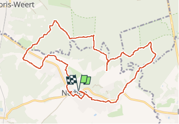
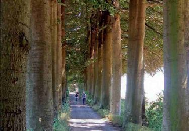
Trail Walking of 11.6 km to be discovered at Wallonia, Walloon Brabant, Grez-Doiceau. This trail is proposed by micheldutilleul.
Description
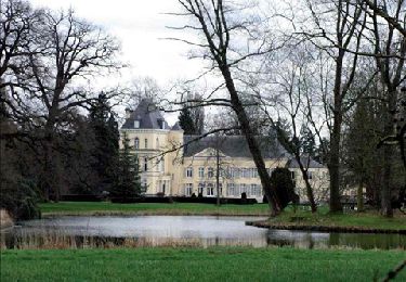
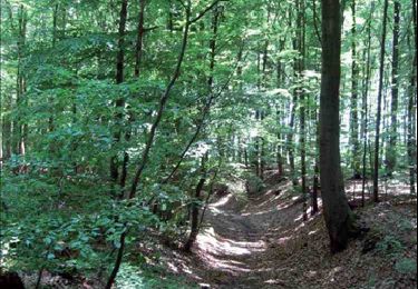
Tres chouette balade, qui est en grande partie dans le bois de Meerdael.
Ne pas faire la petite boucle aller-retour, il s agit d une erreur.
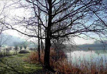
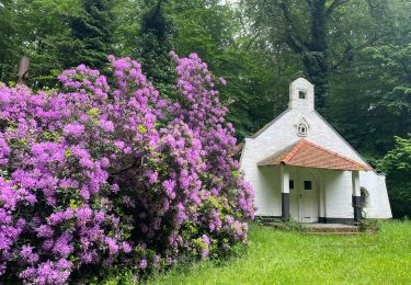
plusieurs endroits avec des bancs pour se poser si besoin.
Positioning
Country:
Belgium
Region :
Wallonia
Department/Province :
Walloon Brabant
Municipality :
Grez-Doiceau
Location:
Unknown
Start:(Dec)
Start:(UTM)
618224 ; 5627182 (31U) N.
Comments
Trails nearby
![Trail Walking Grez-Doiceau - GG-Bw-01_Archennes - Wavre - Photo](https://media.geolcdn.com/t/375/260/290bb459-f7c0-458a-900e-424f97fa157f.jpg&format=jpg&maxdim=2)
![Walking Walking](https://static1.geolcdn.com/sitytour/trail-icons/101.png)
GG-Bw-01_Archennes - Wavre
Walking
Very difficult
(7)
Grez-Doiceau,
Wallonia,
Walloon Brabant,
Belgium
![](/images/other/stat-length.png)
23 km | 28 km-effort
5h 59min
![](https://static1.geolcdn.com/siteimages/upload/files/16400158638029165_repeat_loop_refresh_sync_direction_icon.png)
No
![Trail Walking Grez-Doiceau - RB-BW-06-raccourci 2 - De rivières en collines, au nord de Wavre - Photo](https://media.geolcdn.com/t/375/260/ext.jpg?maxdim=2&url=https%3A%2F%2Fservices.sitytrail.com%2FGeolivesWS%2FDownloadMedia.ashx%3FTrailID%3D219721%26Media%3D21b977c1-3cb7-4170-9cd8-fae609cd623c.jpg)
![Walking Walking](https://static1.geolcdn.com/sitytour/trail-icons/101.png)
RB-BW-06-raccourci 2 - De rivières en collines, au nord de Wavre
Walking
Easy
(5)
Grez-Doiceau,
Wallonia,
Walloon Brabant,
Belgium
![](/images/other/stat-length.png)
7 km | 8.4 km-effort
1h 49min
![](https://static1.geolcdn.com/siteimages/upload/files/16400158638029165_repeat_loop_refresh_sync_direction_icon.png)
Yes
![Trail Walking Grez-Doiceau - RB-BW-06-raccourci 1 - De rivières en collines, au nord de Wavre - Photo](https://media.geolcdn.com/t/375/260/ext.jpg?maxdim=2&url=https%3A%2F%2Fservices.sitytrail.com%2FGeolivesWS%2FDownloadMedia.ashx%3FTrailID%3D219602%26Media%3D265c6b21-1802-4143-b5b1-44460e289445.jpg)
![Walking Walking](https://static1.geolcdn.com/sitytour/trail-icons/101.png)
RB-BW-06-raccourci 1 - De rivières en collines, au nord de Wavre
Walking
Easy
(10)
Grez-Doiceau,
Wallonia,
Walloon Brabant,
Belgium
![](/images/other/stat-length.png)
14.6 km | 17.1 km-effort
3h 52min
![](https://static1.geolcdn.com/siteimages/upload/files/16400158638029165_repeat_loop_refresh_sync_direction_icon.png)
Yes
![Trail Walking Beauvechain - RB-Bw-05 Raccourci 2 - D’un Brabant à l’autre, vaste campagne et grandiose forêt - Photo](https://media.geolcdn.com/t/375/260/ext.jpg?maxdim=2&url=https%3A%2F%2Fservices.sitytrail.com%2FGeolivesWS%2FDownloadMedia.ashx%3FTrailID%3D219540%26Media%3D63e0c1ee-0dba-4936-b50b-5960fe5cf163.jpg)
![Walking Walking](https://static1.geolcdn.com/sitytour/trail-icons/101.png)
RB-Bw-05 Raccourci 2 - D’un Brabant à l’autre, vaste campagne et grandiose forêt
Walking
Very difficult
(5)
Beauvechain,
Wallonia,
Walloon Brabant,
Belgium
![](/images/other/stat-length.png)
18.1 km | 22 km-effort
4h 55min
![](https://static1.geolcdn.com/siteimages/upload/files/16400158638029165_repeat_loop_refresh_sync_direction_icon.png)
Yes
![Trail Walking Grez-Doiceau - RB-BW-06 - De rivières en collines, au nord de Wavre - Photo](https://media.geolcdn.com/t/375/260/ext.jpg?maxdim=2&url=https%3A%2F%2Fservices.sitytrail.com%2FGeolivesWS%2FDownloadMedia.ashx%3FTrailID%3D179581%26Media%3D21b977c1-3cb7-4170-9cd8-fae609cd623c.jpg)
![Walking Walking](https://static1.geolcdn.com/sitytour/trail-icons/101.png)
RB-BW-06 - De rivières en collines, au nord de Wavre
Walking
Easy
(9)
Grez-Doiceau,
Wallonia,
Walloon Brabant,
Belgium
![](/images/other/stat-length.png)
24 km | 28 km-effort
5h 29min
![](https://static1.geolcdn.com/siteimages/upload/files/16400158638029165_repeat_loop_refresh_sync_direction_icon.png)
Yes
![Walking Walking](https://static1.geolcdn.com/sitytour/trail-icons/101.png)
GG2-Bw-21_Pécrot-Genval_2021-11-04
Walking
Very difficult
(3)
Grez-Doiceau,
Wallonia,
Walloon Brabant,
Belgium
![](/images/other/stat-length.png)
26 km | 31 km-effort
7h 7min
![](https://static1.geolcdn.com/siteimages/upload/files/16400158638029165_repeat_loop_refresh_sync_direction_icon.png)
No
![Trail Walking Beauvechain - RB-Bw-05 Raccourci 1 - D’un Brabant à l’autre, vaste campagne et grandiose forêt - Photo](https://media.geolcdn.com/t/375/260/ext.jpg?maxdim=2&url=https%3A%2F%2Fservices.sitytrail.com%2FGeolivesWS%2FDownloadMedia.ashx%3FTrailID%3D219534%26Media%3Df373bb9b-aff6-4afb-ac0c-7f54bf3e8a5b.jpg)
![Walking Walking](https://static1.geolcdn.com/sitytour/trail-icons/101.png)
RB-Bw-05 Raccourci 1 - D’un Brabant à l’autre, vaste campagne et grandiose forêt
Walking
Easy
(2)
Beauvechain,
Wallonia,
Walloon Brabant,
Belgium
![](/images/other/stat-length.png)
20 km | 24 km-effort
5h 27min
![](https://static1.geolcdn.com/siteimages/upload/files/16400158638029165_repeat_loop_refresh_sync_direction_icon.png)
Yes
![Trail Walking Beauvechain - RB-Bw-05 - D’un Brabant à l’autre, vaste campagne et grandiose forêt - Photo](https://media.geolcdn.com/t/375/260/ext.jpg?maxdim=2&url=https%3A%2F%2Fservices.sitytrail.com%2FGeolivesWS%2FDownloadMedia.ashx%3FTrailID%3D179580%26Media%3D63e0c1ee-0dba-4936-b50b-5960fe5cf163.jpg)
![Walking Walking](https://static1.geolcdn.com/sitytour/trail-icons/101.png)
RB-Bw-05 - D’un Brabant à l’autre, vaste campagne et grandiose forêt
Walking
Easy
(4)
Beauvechain,
Wallonia,
Walloon Brabant,
Belgium
![](/images/other/stat-length.png)
24 km | 29 km-effort
6h 10min
![](https://static1.geolcdn.com/siteimages/upload/files/16400158638029165_repeat_loop_refresh_sync_direction_icon.png)
Yes
![Walking Walking](https://static1.geolcdn.com/sitytour/trail-icons/101.png)
#240524b - Forêt de Meerdael, drève et étang de Warande
Walking
Medium
(1)
Beauvechain,
Wallonia,
Walloon Brabant,
Belgium
![](/images/other/stat-length.png)
6.9 km | 8.2 km-effort
1h 51min
![](https://static1.geolcdn.com/siteimages/upload/files/16400158638029165_repeat_loop_refresh_sync_direction_icon.png)
Yes