![](/images/other/stat-length.png)
![Trail Walking L'Étang-la-Ville - boucle de 16 km en forêt de Marly au départ de la gare de Saint-Nom - Photo](https://media.geolcdn.com/t/1900/400/ext.pjpeg?maxdim=2&url=https%3A%2F%2Fstatic1.geolcdn.com%2Fsiteimages%2Fupload%2Ffiles%2F1553511878bg_sport_marche.png)
boucle de 16 km en forêt de Marly au départ de la gare de Saint-Nom
sebastienu
User
![Length](/images/other/stat-length.png)
Length
16.2 km
![Max alt](https://static1.geolcdn.com/siteimages/upload/files/1508320355ic_sort_altitude_max_24dp.png)
Max alt
194 m
![Uphill gradient](https://static1.geolcdn.com/siteimages/upload/files/1508320355ic_sort_den_pos_24dp.png)
Uphill gradient
301 m
![Km-Effort](/images/other/stat-length.png)
Km-Effort
20 km
![Min alt](https://static1.geolcdn.com/siteimages/upload/files/1508320355ic_sort_altitude_min_24dp.png)
Min alt
131 m
![Downhill gradient](https://static1.geolcdn.com/siteimages/upload/files/1508320355ic_sort_den_neg_24dp.png)
Downhill gradient
303 m
![Boucle](https://static1.geolcdn.com/siteimages/upload/files/16400158638029165_repeat_loop_refresh_sync_direction_icon.png)
Boucle
Yes
Creation date :
2023-01-14 17:22:57.313
Updated on :
2023-01-14 17:41:31.857
![Walking](https://static1.geolcdn.com/sitytour/trail-icons/101.png)
4h35
Difficulty : Very difficult
![Scan this QR Code to open this trail in the SityTrail application](https://capi.geolives.com/qq0zvz2zws4bq2lad0pu/sitytour/trails/3518873/qr.png?size=200)
FREE GPS app for hiking
About
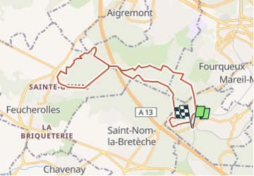
Trail Walking of 16.2 km to be discovered at Ile-de-France, Yvelines, L'Étang-la-Ville. This trail is proposed by sebastienu.
Description
Au départ de la gare de Saint-Nom-la-Bretèche une boucle de 16 km passant sous la 13 pour pousser jusqu'à Saint-Gemme.
On recherche le dénivelé.
Positioning
Country:
France
Region :
Ile-de-France
Department/Province :
Yvelines
Municipality :
L'Étang-la-Ville
Location:
Unknown
Start:(Dec)
Start:(UTM)
430366 ; 5413049 (31U) N.
Comments
Trails nearby
![Trail Walking L'Étang-la-Ville - GRP CV-IDF 2023 - Photo](https://media.geolcdn.com/t/375/260/5b76ffb0-032e-4c30-9eff-c534da0117fa.jpg&format=jpg&maxdim=2)
![Walking Walking](https://static1.geolcdn.com/sitytour/trail-icons/101.png)
GRP CV-IDF 2023
Walking
Difficult
(1)
L'Étang-la-Ville,
Ile-de-France,
Yvelines,
France
![](/images/other/stat-length.png)
10.7 km | 13.7 km-effort
3h 6min
![](https://static1.geolcdn.com/siteimages/upload/files/16400158638029165_repeat_loop_refresh_sync_direction_icon.png)
No
![Trail Walking Chambourcy - Ballade autour du golf de Chambourcy - Photo](https://media.geolcdn.com/t/375/260/ec912980-2058-4871-9f73-872617e204cc.jpg&format=jpg&maxdim=2)
![Walking Walking](https://static1.geolcdn.com/sitytour/trail-icons/101.png)
Ballade autour du golf de Chambourcy
Walking
Medium
(1)
Chambourcy,
Ile-de-France,
Yvelines,
France
![](/images/other/stat-length.png)
8.5 km | 10.6 km-effort
1h 55min
![](https://static1.geolcdn.com/siteimages/upload/files/16400158638029165_repeat_loop_refresh_sync_direction_icon.png)
Yes
![Trail Walking Marly-le-Roi - Boucle 25 km Marly le Roi - Chambourcy - Photo](https://media.geolcdn.com/t/375/260/1fe661ec-cb67-45eb-bf71-8b90e4b33a5d.jpg&format=jpg&maxdim=2)
![Walking Walking](https://static1.geolcdn.com/sitytour/trail-icons/101.png)
Boucle 25 km Marly le Roi - Chambourcy
Walking
Medium
Marly-le-Roi,
Ile-de-France,
Yvelines,
France
![](/images/other/stat-length.png)
25 km | 32 km-effort
7h 15min
![](https://static1.geolcdn.com/siteimages/upload/files/16400158638029165_repeat_loop_refresh_sync_direction_icon.png)
Yes
![Trail Walking Saint-Germain-en-Laye - Audax St Germain en Laye - Paris Tour Eiffel - Photo](https://media.geolcdn.com/t/375/260/5e15adf7-e627-4ac0-b5fd-8bf0b40406ac.jpg&format=jpg&maxdim=2)
![Walking Walking](https://static1.geolcdn.com/sitytour/trail-icons/101.png)
Audax St Germain en Laye - Paris Tour Eiffel
Walking
Easy
Saint-Germain-en-Laye,
Ile-de-France,
Yvelines,
France
![](/images/other/stat-length.png)
29 km | 35 km-effort
4h 59min
![](https://static1.geolcdn.com/siteimages/upload/files/16400158638029165_repeat_loop_refresh_sync_direction_icon.png)
No
![Trail Walking L'Étang-la-Ville - Gare de St Nom - Boucle nocturne Gr ~2h 8,5km - Photo](https://media.geolcdn.com/t/375/260/ext.jpg?maxdim=2&url=https%3A%2F%2Fstatic1.geolcdn.com%2Fsiteimages%2Fupload%2Ffiles%2F1553511878bg_sport_marche.png)
![Walking Walking](https://static1.geolcdn.com/sitytour/trail-icons/101.png)
Gare de St Nom - Boucle nocturne Gr ~2h 8,5km
Walking
Easy
(1)
L'Étang-la-Ville,
Ile-de-France,
Yvelines,
France
![](/images/other/stat-length.png)
24 km | 28 km-effort
12h 14min
![](https://static1.geolcdn.com/siteimages/upload/files/16400158638029165_repeat_loop_refresh_sync_direction_icon.png)
No
![Trail On foot L'Étang-la-Ville - Le tour du Grand Paris par le GR1 Etape 2 - Saint Nom la Bretèche - Triel sur Seine - Photo](https://media.geolcdn.com/t/375/260/1683ad58-8376-4601-9416-cabd4c0df082.jpg&format=jpg&maxdim=2)
![On foot On foot](https://static1.geolcdn.com/sitytour/trail-icons/100.png)
Le tour du Grand Paris par le GR1 Etape 2 - Saint Nom la Bretèche - Triel sur...
On foot
Difficult
L'Étang-la-Ville,
Ile-de-France,
Yvelines,
France
![](/images/other/stat-length.png)
31 km | 36 km-effort
8h 16min
![](https://static1.geolcdn.com/siteimages/upload/files/16400158638029165_repeat_loop_refresh_sync_direction_icon.png)
No
![Trail Walking Marly-le-Roi - 2025 02 05 Louveciennes 11 km - Photo](https://media.geolcdn.com/t/375/260/ext.jpg?maxdim=2&url=https%3A%2F%2Fstatic1.geolcdn.com%2Fsiteimages%2Fupload%2Ffiles%2F1553511878bg_sport_marche.png)
![Walking Walking](https://static1.geolcdn.com/sitytour/trail-icons/101.png)
2025 02 05 Louveciennes 11 km
Walking
Easy
(1)
Marly-le-Roi,
Ile-de-France,
Yvelines,
France
![](/images/other/stat-length.png)
11.2 km | 14.2 km-effort
3h 13min
![](https://static1.geolcdn.com/siteimages/upload/files/16400158638029165_repeat_loop_refresh_sync_direction_icon.png)
Yes
![Walking Walking](https://static1.geolcdn.com/sitytour/trail-icons/101.png)
2024-11-12-Rennemoulin-fontaine de Maltoute
Walking
Medium
Rennemoulin,
Ile-de-France,
Yvelines,
France
![](/images/other/stat-length.png)
6.6 km | 7.8 km-effort
1h 47min
![](https://static1.geolcdn.com/siteimages/upload/files/16400158638029165_repeat_loop_refresh_sync_direction_icon.png)
Yes
![Trail Walking Le Pecq - 20230707 RS - Photo](https://media.geolcdn.com/t/375/260/ext.jpg?maxdim=2&url=https%3A%2F%2Fstatic1.geolcdn.com%2Fsiteimages%2Fupload%2Ffiles%2F1553511878bg_sport_marche.png)
![Walking Walking](https://static1.geolcdn.com/sitytour/trail-icons/101.png)
20230707 RS
Walking
Easy
(1)
Le Pecq,
Ile-de-France,
Yvelines,
France
![](/images/other/stat-length.png)
5 km | 5.8 km-effort
1h 19min
![](https://static1.geolcdn.com/siteimages/upload/files/16400158638029165_repeat_loop_refresh_sync_direction_icon.png)
Yes