Trail Walking Roquefort-la-Bédoule - Grand Caunet- vieux Roquefort - Chap. St André  - Photo

Grand Caunet- vieux Roquefort - Chap. St André

 ego
ego

User

© OpenStreetMap contributors
Length
Length
11.4 km
Max alt
Max alt
560 m
Uphill gradient
Uphill gradient
322 m
Km-Effort
Km-Effort  
15.7 km
Min alt
Min alt
397 m
Downhill gradient
Downhill gradient
322 m
Boucle
Boucle
Yes
Creation date :
2023-01-09 09:28:27.779
Updated on :
2023-01-23 21:38:15.161

(0 Reviews)

Walking
Walking
2h58
Difficulty : Difficult

Scan this QR Code to open this trail in the SityTrail application

FREE GPS app for hiking

Logo SityTrail SityTrail

IGN / Geographical institutes

Download SityTrail from the App Store Download SityTrail from Google Play

Logo SityTrail SityTrail World

The world is yours!

Download SityTrail from the App Store Download SityTrail from Google Play Download SityTrail on Huawei AppGallery

About

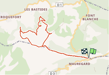
Trail Walking of 11.4 km to be discovered at Provence-Alpes-Côte d'Azur, Bouches-du-Rhône, Roquefort-la-Bédoule. This trail is proposed by ego .

Description

depart parking du grand caunet au dessus de Ceyreste partir vers louest sur le GR  passer le cabanon du marquis ( le marquis de Villeneuve qui la remonté) puis quitter le gr pour aller au ruines du vieux village perché de Roquefort , puis direction de la splendide petite chapelle de St André ou Nd de secheresse , magnifiquement restaurée par un groupe privé de Roquefortais  

Elevation profile

Photos

Positioning

Country:
France
Region :
Provence-Alpes-Côte d'Azur
Department/Province :
Bouches-du-Rhône
Municipality :
Roquefort-la-Bédoule
Location:
Unknown
Start:(UTM)
716801 ; 4790373 (31T) N.

Trails nearby

Trail Walking Roquefort-la-Bédoule - Grand Caunet, le Montounier - Photo
Walking
GUIDE
affinetataille

Walking

Medium
(1)
Roquefort-la-Bédoule, Provence-Alpes-Côte d'Azur, Bouches-du-Rhône, France
16.5 km | 24 km-effort
6h 0min
Yes
Trail Walking Ceyreste - Autour du Montounier 2eme version - Photo
Walking
GUIDE
affinetataille

Walking

Medium
(1)
Ceyreste, Provence-Alpes-Côte d'Azur, Bouches-du-Rhône, France
15.7 km | 24 km-effort
6h 0min
Yes
Trail Walking Roquefort-la-Bédoule - SityTrail - Grand Caunet, Cabanons, Vigie , Grotte Raymond, Ruines roquefort, Chapelle St andré - Photo
Walking
GUIDE
affinetataille

Walking

Easy
(1)
Roquefort-la-Bédoule, Provence-Alpes-Côte d'Azur, Bouches-du-Rhône, France
14.2 km | 19.9 km-effort
6h 0min
Yes
Trail Walking Le Castellet - SityTrail - 2361987 - begude - Photo
Walking
GUIDE
affinetataille

Walking

Medium
(1)
Le Castellet, Provence-Alpes-Côte d'Azur, Var, France
11.5 km | 15.1 km-effort
4h 0min
Yes
Trail Walking Roquefort-la-Bédoule - la petite sainte baume - Photo
Walking
Coryphene

Walking

Easy
(1)
Roquefort-la-Bédoule, Provence-Alpes-Côte d'Azur, Bouches-du-Rhône, France
13.9 km | 19.3 km-effort
5h 37min
Yes
Trail Walking Roquefort-la-Bédoule - Barres de Font Blanche - Photo
Walking
tracegps

Walking

Medium
(1)
Roquefort-la-Bédoule, Provence-Alpes-Côte d'Azur, Bouches-du-Rhône, France
10.3 km | 14.4 km-effort
2h 19min
Yes
Trail Nordic walking La Cadière-d'Azur - 20220329_La Cadière d'Azur - Photo
Nordic walking
Marcsaintcyr

Nordic walking

Very easy
(1)
La Cadière-d'Azur, Provence-Alpes-Côte d'Azur, Var, France
6.8 km | 8.6 km-effort
1h 30min
Yes
Trail Nordic walking La Cadière-d'Azur - 20220329_La Cadière d'Azur - Photo
Nordic walking
Marcsaintcyr

Nordic walking

Very easy
(1)
La Cadière-d'Azur, Provence-Alpes-Côte d'Azur, Var, France
6.8 km | 8.6 km-effort
1h 30min
Yes
Trail Walking Cuges-les-Pins - cuges barres de castillon OK coral - Photo
Walking
michelpaulin

Walking

Medium
(1)
Cuges-les-Pins, Provence-Alpes-Côte d'Azur, Bouches-du-Rhône, France
10.9 km | 14.9 km-effort
5h 54min
Yes


Close
My subscriptions