![](/images/other/stat-length.png)
![Trail Walking Saint-Amarin - 68 Wesserling - Ranspach - Photo](https://media.geolcdn.com/t/1900/400/c6ff0ea4-caab-4159-8f92-5741b11f3c27.jpg&format=pjpeg&maxdim=2)
68 Wesserling - Ranspach
E.BURCK
User
![Length](/images/other/stat-length.png)
![Max alt](https://static1.geolcdn.com/siteimages/upload/files/1508320355ic_sort_altitude_max_24dp.png)
![Uphill gradient](https://static1.geolcdn.com/siteimages/upload/files/1508320355ic_sort_den_pos_24dp.png)
![Km-Effort](/images/other/stat-length.png)
![Min alt](https://static1.geolcdn.com/siteimages/upload/files/1508320355ic_sort_altitude_min_24dp.png)
![Downhill gradient](https://static1.geolcdn.com/siteimages/upload/files/1508320355ic_sort_den_neg_24dp.png)
![Boucle](https://static1.geolcdn.com/siteimages/upload/files/16400158638029165_repeat_loop_refresh_sync_direction_icon.png)
![Walking](https://static1.geolcdn.com/sitytour/trail-icons/101.png)
6h52
Difficulty : Medium
![Scan this QR Code to open this trail in the SityTrail application](https://capi.geolives.com/qq0zvz2zws4bq2lad0pu/sitytour/trails/3507361/qr.png?size=200)
FREE GPS app for hiking
About
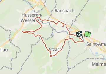
Trail Walking of 8.9 km to be discovered at Grand Est, Haut-Rhin, Saint-Amarin. This trail is proposed by E.BURCK.
Description
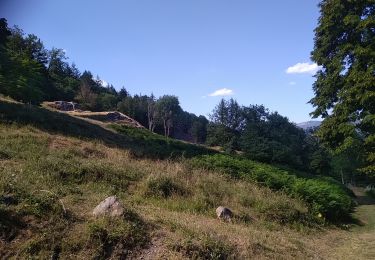
Une balade inédite et facile dans les hauteurs de Mitzach vers Ranspach. Dénivelé de 220 m sur 11.3 km.
ACCÈS :
-prendre la direction de Thann puis St Amarin,
- à la hauteur de Malmerspach, au rond point, quitter la N66 pour la D141 en direction de St Amarin,
- rester sur la rue Charles de Gaulle (D141) jusqu'au niveau de l'office du tourisme et de l'hôtel du Cheval Blanc,
-tourner à gauche en direction de la gare et de l'étang du Firmenweiher dans la rue du Général Joffre,
-continuer tout droit dans cette rue jusqu'au niveau des cours de tennis, le parking est sur votre droite.
PARKING:
- parking en face des cours de tennis au 19 rue du Maréchal Joffre à St Amarin.
47.87253, 7.026447 ou
N 47°52'21", E 7°01'35"
HEURE DE RENDEZ VOUS :
9h30
RESTAURATION :
Restaurant: "Le Flamma Eck" à côté du camping les Bouleaux. 8 rue des Bouleaux à Ranspach
Tél.: 03 89 82 64 70
Positioning
Comments
Trails nearby
![Trail Walking Oderen - TREK ALSACIEN (boucle, la meute) - Photo](https://media.geolcdn.com/t/375/260/bce13479-4ed1-47a7-a848-8fc9fefb1457.jpg&format=jpg&maxdim=2)
![Walking Walking](https://static1.geolcdn.com/sitytour/trail-icons/101.png)
Walking
![](/images/other/stat-length.png)
![](https://static1.geolcdn.com/siteimages/upload/files/16400158638029165_repeat_loop_refresh_sync_direction_icon.png)
![Trail Walking Oderen - Oderen Bergenbach Langenbach - Photo](https://media.geolcdn.com/t/375/260/05163254-f106-4300-b7bd-e85eb3e624ac.jpg&format=jpg&maxdim=2)
![Walking Walking](https://static1.geolcdn.com/sitytour/trail-icons/101.png)
Walking
![](/images/other/stat-length.png)
![](https://static1.geolcdn.com/siteimages/upload/files/16400158638029165_repeat_loop_refresh_sync_direction_icon.png)
![Trail Walking Mollau - Le rossberg - Photo](https://media.geolcdn.com/t/375/260/e1c84c66-d799-45c0-a7df-12e4ffcf0bb2.jpg&format=jpg&maxdim=2)
![Walking Walking](https://static1.geolcdn.com/sitytour/trail-icons/101.png)
![Trail Walking Oderen - TREK ALSACIEN (1ère étape) - Photo](https://media.geolcdn.com/t/375/260/787fe892-71a8-4daf-8eb0-6ad69c3ebb22.jpg&format=jpg&maxdim=2)
![Walking Walking](https://static1.geolcdn.com/sitytour/trail-icons/101.png)
Walking
![](/images/other/stat-length.png)
![](https://static1.geolcdn.com/siteimages/upload/files/16400158638029165_repeat_loop_refresh_sync_direction_icon.png)
![Trail Walking Ranspach - Rando des Marcheurs 20/07/2023 - Photo](https://media.geolcdn.com/t/375/260/e65497d0-16d3-4e63-993c-c9f6fe260f85.jpg&format=jpg&maxdim=2)
![Walking Walking](https://static1.geolcdn.com/sitytour/trail-icons/101.png)
Walking
![](/images/other/stat-length.png)
![](https://static1.geolcdn.com/siteimages/upload/files/16400158638029165_repeat_loop_refresh_sync_direction_icon.png)
![Trail Walking Storckensohn - Storckensohn Gazon Vert - Photo](https://media.geolcdn.com/t/375/260/dded2964-83d5-49a7-93b2-6596b313048d.jpg&format=jpg&maxdim=2)
![Walking Walking](https://static1.geolcdn.com/sitytour/trail-icons/101.png)
Walking
![](/images/other/stat-length.png)
![](https://static1.geolcdn.com/siteimages/upload/files/16400158638029165_repeat_loop_refresh_sync_direction_icon.png)
![Trail Walking Saint-Amarin - dimanche - Photo](https://media.geolcdn.com/t/375/260/ext.jpg?maxdim=2&url=https%3A%2F%2Fstatic1.geolcdn.com%2Fsiteimages%2Fupload%2Ffiles%2F1553511878bg_sport_marche.png)
![Walking Walking](https://static1.geolcdn.com/sitytour/trail-icons/101.png)
Walking
![](/images/other/stat-length.png)
![](https://static1.geolcdn.com/siteimages/upload/files/16400158638029165_repeat_loop_refresh_sync_direction_icon.png)
![Trail Walking Moosch - Moosch Haag - Photo](https://media.geolcdn.com/t/375/260/ext.jpg?maxdim=2&url=https%3A%2F%2Fstatic1.geolcdn.com%2Fsiteimages%2Fupload%2Ffiles%2F1553511878bg_sport_marche.png)
![Walking Walking](https://static1.geolcdn.com/sitytour/trail-icons/101.png)
Walking
![](/images/other/stat-length.png)
![](https://static1.geolcdn.com/siteimages/upload/files/16400158638029165_repeat_loop_refresh_sync_direction_icon.png)
![Trail Walking Oderen - TREK ALSACIEN (boucle, Odin) - Photo](https://media.geolcdn.com/t/375/260/dddd2487-4fb8-4cef-bf36-6235f5cea729.jpg&format=jpg&maxdim=2)
![Walking Walking](https://static1.geolcdn.com/sitytour/trail-icons/101.png)
Walking
![](/images/other/stat-length.png)
![](https://static1.geolcdn.com/siteimages/upload/files/16400158638029165_repeat_loop_refresh_sync_direction_icon.png)