Trail Walking La Ciotat - la ciotat ND la garde vers le sémaphore par les chemins  - Photo

la ciotat ND la garde vers le sémaphore par les chemins

 ego
ego

User

© OpenStreetMap contributors
Length
Length
3.6 km
Max alt
Max alt
302 m
Uphill gradient
Uphill gradient
316 m
Km-Effort
Km-Effort  
7 km
Min alt
Min alt
16 m
Downhill gradient
Downhill gradient
76 m
Boucle
Boucle
No
Creation date :
2023-01-03 08:13:05.527
Updated on :
2023-01-05 16:21:45.51

(0 Reviews)

Walking
Walking
1h29
Difficulty : Medium

Scan this QR Code to open this trail in the SityTrail application

FREE GPS app for hiking

Logo SityTrail SityTrail

IGN / Geographical institutes

Download SityTrail from the App Store Download SityTrail from Google Play

Logo SityTrail SityTrail World

The world is yours!

Download SityTrail from the App Store Download SityTrail from Google Play Download SityTrail on Huawei AppGallery

About

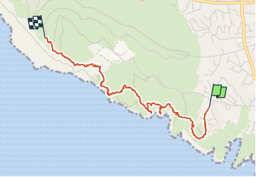
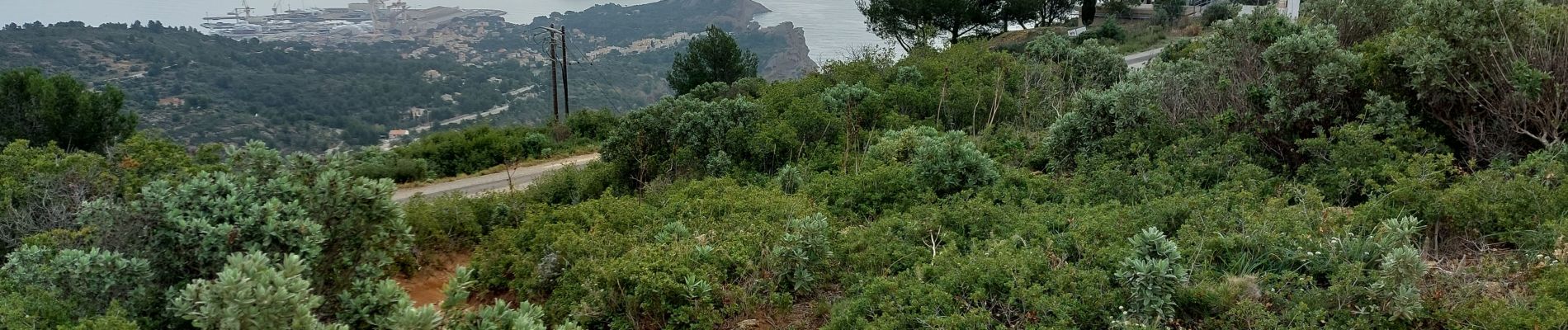
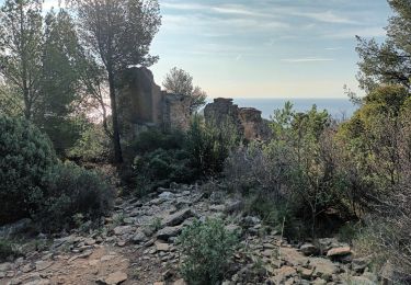
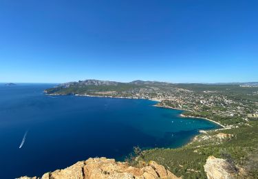
Trail Walking of 3.6 km to be discovered at Provence-Alpes-Côte d'Azur, Bouches-du-Rhône, La Ciotat. This trail is proposed by ego .

Description

depart de la chapelle, traverser l'ex propriété Michel Simon en essayant de suivre une vieille trace verte , pour descendre au fond du talweg du Cannier( passage délicat, mais faisable pour un randonneur ). Le seul du parcours . puis remonter vers la ruine Spaeny, puis descente au fond du vallon st Fretouse pour monter a l'ancienne villa Teychené  et là, en tournant le dos a la maison, sur la gauche, un cairn a 30metres  marque le début d'une sente qui monte au sémaphore  sans difficultés .

Elevation profile

Photos

Positioning

Country:
France
Region :
Provence-Alpes-Côte d'Azur
Department/Province :
Bouches-du-Rhône
Municipality :
La Ciotat
Location:
Unknown
Start:(UTM)
710820 ; 4782908 (31T) N.

Trails nearby

Trail Road bike Cassis - 7909608-TRIMRS2017_Parcours Bike L V5 - Photo
Road bike
GUIDE+

Road bike

Medium
(1)
Cassis, Provence-Alpes-Côte d'Azur, Bouches-du-Rhône, France
21 km | 26 km-effort
1h 31min
No
Trail Walking La Ciotat - Rando Ciotat - Photo
Walking
GUIDE
affinetataille

Walking

Difficult
(1)
La Ciotat, Provence-Alpes-Côte d'Azur, Bouches-du-Rhône, France
12.1 km | 19.9 km-effort
7h 30min
Yes
Trail Walking La Ciotat - la ciotat - Photo
Walking
Berrangerannick

Walking

Very easy
(1)
La Ciotat, Provence-Alpes-Côte d'Azur, Bouches-du-Rhône, France
6.2 km | 9.3 km-effort
3h 21min
Yes
Trail Walking La Ciotat - Balade La Ciotat  - Photo
Walking
BADEY

Walking

Difficult
(1)
La Ciotat, Provence-Alpes-Côte d'Azur, Bouches-du-Rhône, France
8.8 km | 14 km-effort
3h 7min
Yes
Trail Walking La Ciotat - Cap Canaille - Photo
Walking
DanielROLLET

Walking

Medium
(1)
La Ciotat, Provence-Alpes-Côte d'Azur, Bouches-du-Rhône, France
10.2 km | 16.2 km-effort
4h 0min
Yes
Trail Walking La Ciotat - ND de la Garde depuis le Sémaphore 4.1.24 - Photo
Walking
GUIDE
fredetpascale

Walking

Medium
La Ciotat, Provence-Alpes-Côte d'Azur, Bouches-du-Rhône, France
7.6 km | 12.4 km-effort
3h 20min
Yes
Trail Walking La Ciotat - Sémaphore bec de l'Aigle, la Ciotat, 04-10-23  - Photo
Walking
Christiancordin

Walking

Medium
La Ciotat, Provence-Alpes-Côte d'Azur, Bouches-du-Rhône, France
13 km | 19.6 km-effort
3h 53min
Yes
Trail Walking La Ciotat - La Ciotat Cassis par la falaise cap canaille  - Photo
Walking
GUIDE
antignacs

Walking

Easy
La Ciotat, Provence-Alpes-Côte d'Azur, Bouches-du-Rhône, France
7.6 km | 14 km-effort
3h 47min
No
Trail Walking La Ciotat - la ciotat  boucle St Croix  - Photo
Walking
ego

Walking

Medium
La Ciotat, Provence-Alpes-Côte d'Azur, Bouches-du-Rhône, France
4.2 km | 6.8 km-effort
1h 37min
Yes


Close
My subscriptions