![](/images/other/stat-length.png)
![Trail Walking Val-d'Arc - tour du haut de Randens - Photo](https://media.geolcdn.com/t/1900/400/aa8a7963-0ce0-4bad-bb6f-4b975d8a3b5b.jpg&format=pjpeg&maxdim=2)
tour du haut de Randens
jibebouvier
User
![Length](/images/other/stat-length.png)
![Max alt](https://static1.geolcdn.com/siteimages/upload/files/1508320355ic_sort_altitude_max_24dp.png)
![Uphill gradient](https://static1.geolcdn.com/siteimages/upload/files/1508320355ic_sort_den_pos_24dp.png)
![Km-Effort](/images/other/stat-length.png)
![Min alt](https://static1.geolcdn.com/siteimages/upload/files/1508320355ic_sort_altitude_min_24dp.png)
![Downhill gradient](https://static1.geolcdn.com/siteimages/upload/files/1508320355ic_sort_den_neg_24dp.png)
![Boucle](https://static1.geolcdn.com/siteimages/upload/files/16400158638029165_repeat_loop_refresh_sync_direction_icon.png)
![Walking](https://static1.geolcdn.com/sitytour/trail-icons/101.png)
2h48
Difficulty : Medium
![Scan this QR Code to open this trail in the SityTrail application](https://capi.geolives.com/qq0zvz2zws4bq2lad0pu/sitytour/trails/3505046/qr.png?size=200)
FREE GPS app for hiking
About
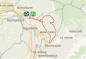
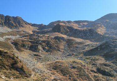
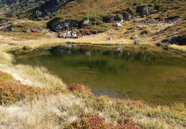
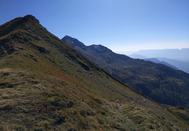
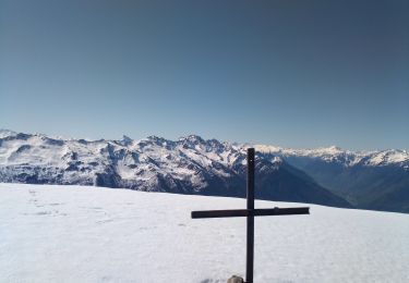
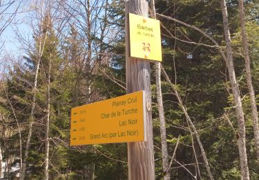
Trail Walking of 13 km to be discovered at Auvergne-Rhône-Alpes, Savoy, Val-d'Arc. This trail is proposed by jibebouvier.
Description
en passant par Coisse, Montfort, la chapelle de Montsapey, et prendre direction la place des dépôts de bois juste en dessous le trou du loup.
Là, longue traversée quasi à plat jusqu'en dessous des Mauilles, puis retour tout dré dans le pentu ;-)
15,8km 3D et 1300 m dénivelé.
bonne balade
Positioning
Comments
Trails nearby
![Trail Walking Montsapey - Lac Clartan et plus - Photo](https://media.geolcdn.com/t/375/260/a3945484-2742-42e9-b6c0-fb5c4b25df2b.jpg&format=jpg&maxdim=2)
![Walking Walking](https://static1.geolcdn.com/sitytour/trail-icons/101.png)
Walking
![](/images/other/stat-length.png)
![](https://static1.geolcdn.com/siteimages/upload/files/16400158638029165_repeat_loop_refresh_sync_direction_icon.png)
![Trail Touring skiing Montsapey - pas de Freydon - Photo](https://media.geolcdn.com/t/375/260/878ecc25-aa9c-40b4-b58b-a735c66cffef.jpg&format=jpg&maxdim=2)
![Touring skiing Touring skiing](https://static1.geolcdn.com/sitytour/trail-icons/503.png)
Touring skiing
![](/images/other/stat-length.png)
![](https://static1.geolcdn.com/siteimages/upload/files/16400158638029165_repeat_loop_refresh_sync_direction_icon.png)
![Trail Walking Val-d'Arc - Grand Arc - Photo](https://media.geolcdn.com/t/375/260/ext.jpg?maxdim=2&url=https%3A%2F%2Fstatic1.geolcdn.com%2Fsiteimages%2Fupload%2Ffiles%2F1553511878bg_sport_marche.png)
![Walking Walking](https://static1.geolcdn.com/sitytour/trail-icons/101.png)
Walking
![](/images/other/stat-length.png)
![](https://static1.geolcdn.com/siteimages/upload/files/16400158638029165_repeat_loop_refresh_sync_direction_icon.png)
![Trail Walking Montsapey - portes de Montmélian par le col des fretes - Photo](https://media.geolcdn.com/t/375/260/90286a5c-8381-4fdf-9211-0d4b99111163.jpg&format=jpg&maxdim=2)
![Walking Walking](https://static1.geolcdn.com/sitytour/trail-icons/101.png)
Walking
![](/images/other/stat-length.png)
![](https://static1.geolcdn.com/siteimages/upload/files/16400158638029165_repeat_loop_refresh_sync_direction_icon.png)
![Trail Walking Montgilbert - les batteries par Montgilbert - Photo](https://media.geolcdn.com/t/375/260/f104cb28-96a4-49e7-af5f-60f831324464.jpg&format=jpg&maxdim=2)
![Walking Walking](https://static1.geolcdn.com/sitytour/trail-icons/101.png)
Walking
![](/images/other/stat-length.png)
![](https://static1.geolcdn.com/siteimages/upload/files/16400158638029165_repeat_loop_refresh_sync_direction_icon.png)
![Trail Walking Sainte-Hélène-sur-Isère - 27 09 23 le Grand Arc - Photo](https://media.geolcdn.com/t/375/260/06827bae-7a14-40e2-996f-75ece7e1ce9b.jpg&format=jpg&maxdim=2)
![Walking Walking](https://static1.geolcdn.com/sitytour/trail-icons/101.png)
Walking
![](/images/other/stat-length.png)
![](https://static1.geolcdn.com/siteimages/upload/files/16400158638029165_repeat_loop_refresh_sync_direction_icon.png)
![Trail Walking Sainte-Hélène-sur-Isère - 26 09 23 la dent du corbeau par la grande lanche - Photo](https://media.geolcdn.com/t/375/260/87de882e-a65f-4159-b9ac-8bc46446cbc4.jpg&format=jpg&maxdim=2)
![Walking Walking](https://static1.geolcdn.com/sitytour/trail-icons/101.png)
Walking
![](/images/other/stat-length.png)
![](https://static1.geolcdn.com/siteimages/upload/files/16400158638029165_repeat_loop_refresh_sync_direction_icon.png)
![Trail Walking Montsapey - petit arc par bataille dessus printemps - Photo](https://media.geolcdn.com/t/375/260/3bc7f631-fc7c-488f-b081-67d83a0e2dae.jpg&format=jpg&maxdim=2)
![Walking Walking](https://static1.geolcdn.com/sitytour/trail-icons/101.png)
Walking
![](/images/other/stat-length.png)
![](https://static1.geolcdn.com/siteimages/upload/files/16400158638029165_repeat_loop_refresh_sync_direction_icon.png)
![Trail Walking Montsapey - la chapelle de montsap' lac noir - Photo](https://media.geolcdn.com/t/375/260/d1b6e184-6050-487d-bf66-654bd3da97db.jpg&format=jpg&maxdim=2)
![Walking Walking](https://static1.geolcdn.com/sitytour/trail-icons/101.png)
Walking
![](/images/other/stat-length.png)
![](https://static1.geolcdn.com/siteimages/upload/files/16400158638029165_repeat_loop_refresh_sync_direction_icon.png)