![](/images/other/stat-length.png)
![Trail Walking La Grande-Motte - La Grande Motte, visite du couchant - Photo](https://media.geolcdn.com/t/1900/400/ext.pjpeg?maxdim=2&url=https%3A%2F%2Fservices.sitytrail.com%2FGeolivesWS%2FDownloadMedia.ashx%3FTrailID%3D350392%26Media%3Dfix__20140718161954.jpg)
La Grande Motte, visite du couchant
neo34980
User
![Length](/images/other/stat-length.png)
Length
5.2 km
![Max alt](https://static1.geolcdn.com/siteimages/upload/files/1508320355ic_sort_altitude_max_24dp.png)
Max alt
14 m
![Uphill gradient](https://static1.geolcdn.com/siteimages/upload/files/1508320355ic_sort_den_pos_24dp.png)
Uphill gradient
31 m
![Km-Effort](/images/other/stat-length.png)
Km-Effort
5.6 km
![Min alt](https://static1.geolcdn.com/siteimages/upload/files/1508320355ic_sort_altitude_min_24dp.png)
Min alt
1 m
![Downhill gradient](https://static1.geolcdn.com/siteimages/upload/files/1508320355ic_sort_den_neg_24dp.png)
Downhill gradient
32 m
![Boucle](https://static1.geolcdn.com/siteimages/upload/files/16400158638029165_repeat_loop_refresh_sync_direction_icon.png)
Boucle
No
Creation date :
2014-12-10 00:00:00.0
Updated on :
2014-12-10 00:00:00.0
![Walking](https://static1.geolcdn.com/sitytour/trail-icons/101.png)
1h26
Difficulty : Easy
![Scan this QR Code to open this trail in the SityTrail application](https://capi.geolives.com/qq0zvz2zws4bq2lad0pu/sitytour/trails/350392/qr.png?size=200)
FREE GPS app for hiking
About
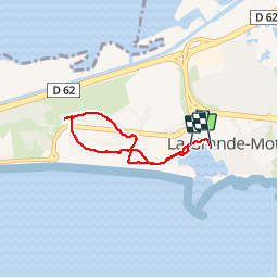
Trail Walking of 5.2 km to be discovered at Occitania, Hérault, La Grande-Motte. This trail is proposed by neo34980.
Description
départ de la pyramide et deambulation dans le Couchant. Retour centre ville.
Positioning
Country:
France
Region :
Occitania
Department/Province :
Hérault
Municipality :
La Grande-Motte
Location:
Unknown
Start:(Dec)
Start:(UTM)
587185 ; 4823576 (31T) N.
Comments
Trails nearby
![Trail Walking Mauguio - sa 7 mars 2015 mauguio - Photo](https://media.geolcdn.com/t/375/260/ext.jpg?maxdim=2&url=https%3A%2F%2Fservices.sitytrail.com%2FGeolivesWS%2FDownloadMedia.ashx%3FTrailID%3D393117%26Media%3Dfix__20150307120533.jpg)
![Walking Walking](https://static1.geolcdn.com/sitytour/trail-icons/101.png)
sa 7 mars 2015 mauguio
Walking
Very easy
(1)
Mauguio,
Occitania,
Hérault,
France
![](/images/other/stat-length.png)
9.6 km | 9.8 km-effort
2h 23min
![](https://static1.geolcdn.com/siteimages/upload/files/16400158638029165_repeat_loop_refresh_sync_direction_icon.png)
Yes
![Trail Walking La Grande-Motte - L'empreinte de l'architecte Jean Balladur - Photo](https://media.geolcdn.com/t/375/260/ext.jpg?maxdim=2&url=https%3A%2F%2Fservices.sitytrail.com%2FGeolivesWS%2FDownloadMedia.ashx%3FTrailID%3D343894%26Media%3Dfix__20140910145554.jpg)
![Walking Walking](https://static1.geolcdn.com/sitytour/trail-icons/101.png)
L'empreinte de l'architecte Jean Balladur
Walking
Very easy
(1)
La Grande-Motte,
Occitania,
Hérault,
France
![](/images/other/stat-length.png)
7.7 km | 8.4 km-effort
1h 43min
![](https://static1.geolcdn.com/siteimages/upload/files/16400158638029165_repeat_loop_refresh_sync_direction_icon.png)
No
![Trail Mountain bike La Grande-Motte - canal aigues mortes - Photo](https://media.geolcdn.com/t/375/260/ext.jpg?maxdim=2&url=https%3A%2F%2Fservices.sitytrail.com%2FGeolivesWS%2FDownloadMedia.ashx%3FTrailID%3D216094%26Media%3Dfix__20130823103155.jpg)
![Mountain bike Mountain bike](https://static1.geolcdn.com/sitytour/trail-icons/202.png)
canal aigues mortes
Mountain bike
Medium
(3)
La Grande-Motte,
Occitania,
Hérault,
France
![](/images/other/stat-length.png)
41 km | 43 km-effort
2h 18min
![](https://static1.geolcdn.com/siteimages/upload/files/16400158638029165_repeat_loop_refresh_sync_direction_icon.png)
Yes
![Trail Road bike Le Grau-du-Roi - 30 Lunel aigues morte - Photo](https://media.geolcdn.com/t/375/260/ext.jpg?maxdim=2&url=https%3A%2F%2Fstatic1.geolcdn.com%2Fsiteimages%2Fupload%2Ffiles%2F1524743154velo.jpg)
![Road bike Road bike](https://static1.geolcdn.com/sitytour/trail-icons/201.png)
30 Lunel aigues morte
Road bike
Medium
(1)
Le Grau-du-Roi,
Occitania,
Gard,
France
![](/images/other/stat-length.png)
45 km | 48 km-effort
6h 26min
![](https://static1.geolcdn.com/siteimages/upload/files/16400158638029165_repeat_loop_refresh_sync_direction_icon.png)
No
![Trail Walking La Grande-Motte - la Grande Motte - coulée verte - Photo](https://media.geolcdn.com/t/375/260/552d5643-9b2a-44ae-80a1-871da30ed804.jpg&format=jpg&maxdim=2)
![Walking Walking](https://static1.geolcdn.com/sitytour/trail-icons/101.png)
la Grande Motte - coulée verte
Walking
Medium
La Grande-Motte,
Occitania,
Hérault,
France
![](/images/other/stat-length.png)
9 km | 9.7 km-effort
2h 11min
![](https://static1.geolcdn.com/siteimages/upload/files/16400158638029165_repeat_loop_refresh_sync_direction_icon.png)
Yes
![Trail Road bike Le Grau-du-Roi - 30 Lunel st Laurent aigouze gallician vv - Photo](https://media.geolcdn.com/t/375/260/02372f93-729e-41ea-ab56-4cb60c432fa9.jpg&format=jpg&maxdim=2)
![Road bike Road bike](https://static1.geolcdn.com/sitytour/trail-icons/201.png)
30 Lunel st Laurent aigouze gallician vv
Road bike
Medium
Le Grau-du-Roi,
Occitania,
Gard,
France
![](/images/other/stat-length.png)
59 km | 63 km-effort
5h 34min
![](https://static1.geolcdn.com/siteimages/upload/files/16400158638029165_repeat_loop_refresh_sync_direction_icon.png)
Yes
![Trail Road bike Le Grau-du-Roi - 30 vélo lunel gte motte a morte - Photo](https://media.geolcdn.com/t/375/260/be90f8e0-cf6e-4642-ba36-0b8e272023aa.jpg&format=jpg&maxdim=2)
![Road bike Road bike](https://static1.geolcdn.com/sitytour/trail-icons/201.png)
30 vélo lunel gte motte a morte
Road bike
Medium
Le Grau-du-Roi,
Occitania,
Gard,
France
![](/images/other/stat-length.png)
66 km | 70 km-effort
6h 58min
![](https://static1.geolcdn.com/siteimages/upload/files/16400158638029165_repeat_loop_refresh_sync_direction_icon.png)
Yes
![Trail Walking La Grande-Motte - Grande_Motte - Photo](https://media.geolcdn.com/t/375/260/04f24743-7b04-4e1a-8590-c3d6ada8229a.jpg&format=jpg&maxdim=2)
![Walking Walking](https://static1.geolcdn.com/sitytour/trail-icons/101.png)
Grande_Motte
Walking
Medium
La Grande-Motte,
Occitania,
Hérault,
France
![](/images/other/stat-length.png)
8.7 km | 9.5 km-effort
2h 10min
![](https://static1.geolcdn.com/siteimages/upload/files/16400158638029165_repeat_loop_refresh_sync_direction_icon.png)
Yes
![Trail Walking Le Grau-du-Roi - Le Grau du Roi Port Camargue - Photo](https://media.geolcdn.com/t/375/260/96ddca6b-237d-4a9a-adbc-9ad8f5fc746e.jpg&format=jpg&maxdim=2)
![Walking Walking](https://static1.geolcdn.com/sitytour/trail-icons/101.png)
Le Grau du Roi Port Camargue
Walking
Medium
Le Grau-du-Roi,
Occitania,
Gard,
France
![](/images/other/stat-length.png)
6.8 km | 7.3 km-effort
2h 15min
![](https://static1.geolcdn.com/siteimages/upload/files/16400158638029165_repeat_loop_refresh_sync_direction_icon.png)
Yes