![](/images/other/stat-length.png)
![Trail Walking Saint-Fortunat-sur-Eyrieux - 2022_12_18_TMS_St Fortunat_ST JULIEN LE Roux - Photo](https://media.geolcdn.com/t/1900/400/ext.pjpeg?maxdim=2&url=https%3A%2F%2Fstatic1.geolcdn.com%2Fsiteimages%2Fupload%2Ffiles%2F1553511878bg_sport_marche.png)
2022_12_18_TMS_St Fortunat_ST JULIEN LE Roux
Chamois30
User
![Length](/images/other/stat-length.png)
Length
18.8 km
![Max alt](https://static1.geolcdn.com/siteimages/upload/files/1508320355ic_sort_altitude_max_24dp.png)
Max alt
694 m
![Uphill gradient](https://static1.geolcdn.com/siteimages/upload/files/1508320355ic_sort_den_pos_24dp.png)
Uphill gradient
820 m
![Km-Effort](/images/other/stat-length.png)
Km-Effort
30 km
![Min alt](https://static1.geolcdn.com/siteimages/upload/files/1508320355ic_sort_altitude_min_24dp.png)
Min alt
139 m
![Downhill gradient](https://static1.geolcdn.com/siteimages/upload/files/1508320355ic_sort_den_neg_24dp.png)
Downhill gradient
821 m
![Boucle](https://static1.geolcdn.com/siteimages/upload/files/16400158638029165_repeat_loop_refresh_sync_direction_icon.png)
Boucle
Yes
Creation date :
2022-12-20 08:14:41.95
Updated on :
2022-12-21 12:19:39.944
![Walking](https://static1.geolcdn.com/sitytour/trail-icons/101.png)
4h49
Difficulty : Medium
![Scan this QR Code to open this trail in the SityTrail application](https://capi.geolives.com/qq0zvz2zws4bq2lad0pu/sitytour/trails/3487844/qr.png?size=200)
FREE GPS app for hiking
About
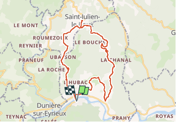
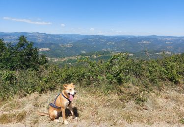
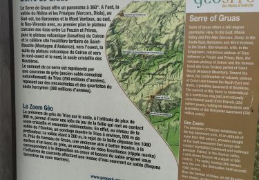
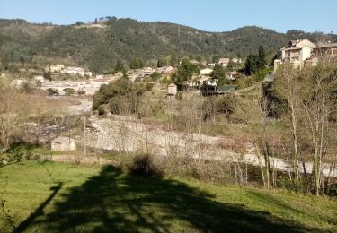
Trail Walking of 18.8 km to be discovered at Auvergne-Rhône-Alpes, Ardèche, Saint-Fortunat-sur-Eyrieux. This trail is proposed by Chamois30.
Description
A/R au hameau de St julien le Roux pour le pic-nique.
fortes côtes à la montée à St Julien.
Une au départ de St Fortunat, l'autre un peu avant l'arrivée à St Julien
Positioning
Country:
France
Region :
Auvergne-Rhône-Alpes
Department/Province :
Ardèche
Municipality :
Saint-Fortunat-sur-Eyrieux
Location:
Unknown
Start:(Dec)
Start:(UTM)
632645 ; 4965031 (31T) N.
Comments
Trails nearby
![Trail Walking Saint-Vincent-de-Durfort - croix de grua - Photo](https://media.geolcdn.com/t/375/260/ext.jpg?maxdim=2&url=https%3A%2F%2Fmedia.geolcdn.com%2Ff%2F8757bbe0-ad12-42b9-b0e8-88a1f3bf1001.jpg)
![Walking Walking](https://static1.geolcdn.com/sitytour/trail-icons/101.png)
croix de grua
Walking
Very difficult
Saint-Vincent-de-Durfort,
Auvergne-Rhône-Alpes,
Ardèche,
France
![](/images/other/stat-length.png)
16.2 km | 25 km-effort
5h 37min
![](https://static1.geolcdn.com/siteimages/upload/files/16400158638029165_repeat_loop_refresh_sync_direction_icon.png)
No
![Trail Walking Les Ollières-sur-Eyrieux - Serré de Gruas - Photo](https://media.geolcdn.com/t/375/260/ext.jpg?maxdim=2&url=https%3A%2F%2Fmedia.geolcdn.com%2Ff%2F08cf67dd-d65b-4d6b-a337-2ee393033a8e.jpg)
![Walking Walking](https://static1.geolcdn.com/sitytour/trail-icons/101.png)
Serré de Gruas
Walking
Easy
Les Ollières-sur-Eyrieux,
Auvergne-Rhône-Alpes,
Ardèche,
France
![](/images/other/stat-length.png)
16.8 km | 27 km-effort
4h 51min
![](https://static1.geolcdn.com/siteimages/upload/files/16400158638029165_repeat_loop_refresh_sync_direction_icon.png)
Yes
![Trail Walking Les Ollières-sur-Eyrieux - la croix du banc - Photo](https://media.geolcdn.com/t/375/260/ext.jpg?maxdim=2&url=https%3A%2F%2Fmedia.geolcdn.com%2Ff%2Fd82c3cd3-35d0-4e92-bd70-cb6fc678571a.jpg)
![Walking Walking](https://static1.geolcdn.com/sitytour/trail-icons/101.png)
la croix du banc
Walking
Medium
Les Ollières-sur-Eyrieux,
Auvergne-Rhône-Alpes,
Ardèche,
France
![](/images/other/stat-length.png)
13.6 km | 20 km-effort
4h 27min
![](https://static1.geolcdn.com/siteimages/upload/files/16400158638029165_repeat_loop_refresh_sync_direction_icon.png)
Yes
![Trail Walking Saint-Vincent-de-Durfort - Randonnée nocturne aux Croix de Gruas - Photo](https://media.geolcdn.com/t/375/260/ext.jpg?maxdim=2&url=https%3A%2F%2Fmedia.geolcdn.com%2Ff%2F9f5fe7bb-9305-41c6-ab29-b616b2a46650.jpg)
![Walking Walking](https://static1.geolcdn.com/sitytour/trail-icons/101.png)
Randonnée nocturne aux Croix de Gruas
Walking
Difficult
Saint-Vincent-de-Durfort,
Auvergne-Rhône-Alpes,
Ardèche,
France
![](/images/other/stat-length.png)
10.3 km | 15.9 km-effort
3h 17min
![](https://static1.geolcdn.com/siteimages/upload/files/16400158638029165_repeat_loop_refresh_sync_direction_icon.png)
Yes
![Trail Walking Saint-Fortunat-sur-Eyrieux - 07 st fortunat dubieres st Vincent dufort - Photo](https://media.geolcdn.com/t/375/260/ext.jpg?maxdim=2&url=https%3A%2F%2Fmedia.geolcdn.com%2Ff%2Fc34c03c4-9768-4a05-aafb-3fcd76453ebb.jpg)
![Walking Walking](https://static1.geolcdn.com/sitytour/trail-icons/101.png)
07 st fortunat dubieres st Vincent dufort
Walking
Medium
Saint-Fortunat-sur-Eyrieux,
Auvergne-Rhône-Alpes,
Ardèche,
France
![](/images/other/stat-length.png)
22 km | 33 km-effort
8h 41min
![](https://static1.geolcdn.com/siteimages/upload/files/16400158638029165_repeat_loop_refresh_sync_direction_icon.png)
Yes
![Trail Walking Les Ollières-sur-Eyrieux - 07 ollieres sur eyrieux Gruas - Photo](https://media.geolcdn.com/t/375/260/ext.jpg?maxdim=2&url=https%3A%2F%2Fmedia.geolcdn.com%2Ff%2F9ffda187-d312-43bf-86a6-ea773d0d4ffe.jpg)
![Walking Walking](https://static1.geolcdn.com/sitytour/trail-icons/101.png)
07 ollieres sur eyrieux Gruas
Walking
Medium
Les Ollières-sur-Eyrieux,
Auvergne-Rhône-Alpes,
Ardèche,
France
![](/images/other/stat-length.png)
16.5 km | 27 km-effort
7h 0min
![](https://static1.geolcdn.com/siteimages/upload/files/16400158638029165_repeat_loop_refresh_sync_direction_icon.png)
Yes
![Trail Walking Dunière-sur-Eyrieux - Duniere reco - Photo](https://media.geolcdn.com/t/375/260/ext.jpg?maxdim=2&url=https%3A%2F%2Fmedia.geolcdn.com%2Ff%2Fcf0e22a2-5839-4204-9a80-7596afd65d2e.jpg)
![Walking Walking](https://static1.geolcdn.com/sitytour/trail-icons/101.png)
Duniere reco
Walking
Medium
Dunière-sur-Eyrieux,
Auvergne-Rhône-Alpes,
Ardèche,
France
![](/images/other/stat-length.png)
12.4 km | 19.3 km-effort
6h 30min
![](https://static1.geolcdn.com/siteimages/upload/files/16400158638029165_repeat_loop_refresh_sync_direction_icon.png)
Yes
![Trail Walking Saint-Cierge-la-Serre - 2023-05-15_19h12m20_St Cierge La Serre 13,5km.gpx.xml - Photo](https://media.geolcdn.com/t/375/260/ext.jpg?maxdim=2&url=https%3A%2F%2Fmedia.geolcdn.com%2Ff%2F5f198452-8c98-4283-ab78-413b9a406c9c.jpg)
![Walking Walking](https://static1.geolcdn.com/sitytour/trail-icons/101.png)
2023-05-15_19h12m20_St Cierge La Serre 13,5km.gpx.xml
Walking
Difficult
Saint-Cierge-la-Serre,
Auvergne-Rhône-Alpes,
Ardèche,
France
![](/images/other/stat-length.png)
13.7 km | 19.8 km-effort
4h 29min
![](https://static1.geolcdn.com/siteimages/upload/files/16400158638029165_repeat_loop_refresh_sync_direction_icon.png)
Yes
![Trail Walking Saint-Fortunat-sur-Eyrieux - St Fortunat - Photo](https://media.geolcdn.com/t/375/260/ext.jpg?maxdim=2&url=https%3A%2F%2Fmedia.geolcdn.com%2Ff%2F381c4b81-0aa1-4f19-b6ca-35bea67274ae.jpg)
![Walking Walking](https://static1.geolcdn.com/sitytour/trail-icons/101.png)
St Fortunat
Walking
Medium
Saint-Fortunat-sur-Eyrieux,
Auvergne-Rhône-Alpes,
Ardèche,
France
![](/images/other/stat-length.png)
16.7 km | 25 km-effort
4h 38min
![](https://static1.geolcdn.com/siteimages/upload/files/16400158638029165_repeat_loop_refresh_sync_direction_icon.png)
Yes