Trail Walking Monferran-Savès - la fin d'un beau tour - Photo

la fin d'un beau tour

  CDSM 55
CDSM 55

User

© OpenStreetMap contributors
Length
Length
1.3 km
Max alt
Max alt
221 m
Uphill gradient
Uphill gradient
9 m
Km-Effort
Km-Effort  
1.5 km
Min alt
Min alt
213 m
Downhill gradient
Downhill gradient
9 m
Boucle
Boucle
No
Creation date :
2022-12-19 15:42:08.937
Updated on :
2022-12-19 16:00:31.972

(1 Reviews)

Walking
Walking
13m
Difficulty : Easy

Scan this QR Code to open this trail in the SityTrail application

FREE GPS app for hiking

Logo SityTrail SityTrail

IGN / Geographical institutes

Download SityTrail from the App Store Download SityTrail from Google Play

Logo SityTrail SityTrail World

The world is yours!

Download SityTrail from the App Store Download SityTrail from Google Play Download SityTrail on Huawei AppGallery

About

Trail Walking of 1.3 km to be discovered at Occitania, Gers, Monferran-Savès. This trail is proposed by CDSM 55.

Elevation profile

Positioning

Country:
France
Region :
Occitania
Department/Province :
Gers
Municipality :
Monferran-Savès
Location:
Unknown
Start:(UTM)
337097 ; 4829270 (31T) N.

Comments

Please log in to post a review or rate the element


dommage que le téléchargement n'a pas fonctionné, il manque 11 km !!


Trails nearby

Trail Walking Monferran-Savès - ses les terres de Monferran Saves et plus - Photo
Walking
CDSM 55

Walking

Difficult
(1)
Monferran-Savès, Occitania, Gers, France
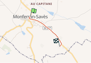
18.6 km | 23 km-effort
3h 37min
Yes
Trail Walking Monferran-Savès - Sur les terres de Monferran Saves  - Photo
Walking
CDSM 55

Walking

Medium
Monferran-Savès, Occitania, Gers, France
8 km | 9.7 km-effort
1h 33min
Yes
Trail Mountain bike Monferran-Savès - les rives de la Saves - Photo
Mountain bike
CDSM 55

Mountain bike

Difficult
Monferran-Savès, Occitania, Gers, France
22 km | 25 km-effort
2h 57min
Yes


Close
My subscriptions