![](/images/other/stat-length.png)
![Trail On foot Pont-Aven - PONT AVEN ROSBRAS AR - Photo](https://media.geolcdn.com/t/1900/400/ext.pjpeg?maxdim=2&url=https%3A%2F%2Fstatic1.geolcdn.com%2Fsiteimages%2Fupload%2Ffiles%2F1545311037marcheuse_200dpi.jpg)
PONT AVEN ROSBRAS AR
JEAN06910
User
![Length](/images/other/stat-length.png)
Length
12.9 km
![Max alt](https://static1.geolcdn.com/siteimages/upload/files/1508320355ic_sort_altitude_max_24dp.png)
Max alt
49 m
![Uphill gradient](https://static1.geolcdn.com/siteimages/upload/files/1508320355ic_sort_den_pos_24dp.png)
Uphill gradient
190 m
![Km-Effort](/images/other/stat-length.png)
Km-Effort
15.4 km
![Min alt](https://static1.geolcdn.com/siteimages/upload/files/1508320355ic_sort_altitude_min_24dp.png)
Min alt
2 m
![Downhill gradient](https://static1.geolcdn.com/siteimages/upload/files/1508320355ic_sort_den_neg_24dp.png)
Downhill gradient
190 m
![Boucle](https://static1.geolcdn.com/siteimages/upload/files/16400158638029165_repeat_loop_refresh_sync_direction_icon.png)
Boucle
Yes
Creation date :
2022-12-13 19:20:34.546
Updated on :
2022-12-13 19:25:46.515
![On foot](https://static1.geolcdn.com/sitytour/trail-icons/100.png)
3h30
Difficulty : Easy
![Scan this QR Code to open this trail in the SityTrail application](https://capi.geolives.com/qq0zvz2zws4bq2lad0pu/sitytour/trails/3480878/qr.png?size=200)
FREE GPS app for hiking
About
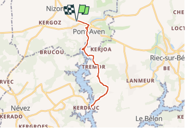
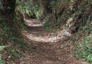
Trail On foot of 12.9 km to be discovered at Brittany, Finistère, Pont-Aven. This trail is proposed by JEAN06910.
Description
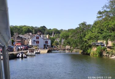
départ de Pénanros, traversée village, port de Rosbras, retour et accès aux illuminations de la ville.
Extension /- 1 kms pour la chapelle de Trémor !
Positioning
Country:
France
Region :
Brittany
Department/Province :
Finistère
Municipality :
Pont-Aven
Location:
Unknown
Start:(Dec)
Start:(UTM)
443580 ; 5300964 (30T) N.
Comments
Trails nearby
![Trail Walking Névez - Samedi 4 novembre 2012 - Photo](https://media.geolcdn.com/t/375/260/ext.jpg?maxdim=2&url=https%3A%2F%2Fstatic1.geolcdn.com%2Fsiteimages%2Fupload%2Ffiles%2F1553511878bg_sport_marche.png)
![Walking Walking](https://static1.geolcdn.com/sitytour/trail-icons/101.png)
Samedi 4 novembre 2012
Walking
Very easy
(1)
Névez,
Brittany,
Finistère,
France
![](/images/other/stat-length.png)
6.6 km | 7.2 km-effort
1h 16min
![](https://static1.geolcdn.com/siteimages/upload/files/16400158638029165_repeat_loop_refresh_sync_direction_icon.png)
Yes
![Trail Walking Névez - NEVEZ - Photo](https://media.geolcdn.com/t/375/260/bd180922-a9c6-4019-8a83-8e814349c428.jpg&format=jpg&maxdim=2)
![Walking Walking](https://static1.geolcdn.com/sitytour/trail-icons/101.png)
![Trail Walking Névez - Le Heant - Photo](https://media.geolcdn.com/t/375/260/2350e410-5d82-4b7f-8685-3c9377a45f94.jpg&format=jpg&maxdim=2)
![Walking Walking](https://static1.geolcdn.com/sitytour/trail-icons/101.png)
![Trail Walking Pont-Aven - Pont Aven boucle via chapelle St Mathieu/Nevez/Le Henan/Penanros - Photo](https://media.geolcdn.com/t/375/260/ba467620-8015-4227-8ddd-4f5ffdaa645a.jpg&format=jpg&maxdim=2)
![Walking Walking](https://static1.geolcdn.com/sitytour/trail-icons/101.png)
Pont Aven boucle via chapelle St Mathieu/Nevez/Le Henan/Penanros
Walking
Very difficult
Pont-Aven,
Brittany,
Finistère,
France
![](/images/other/stat-length.png)
18.3 km | 21 km-effort
3h 3min
![](https://static1.geolcdn.com/siteimages/upload/files/16400158638029165_repeat_loop_refresh_sync_direction_icon.png)
Yes
![Trail Walking Pont-Aven - BOUCLE PONT AVEN / ROSBRAS / RIEC / PONT AVEN - Photo](https://media.geolcdn.com/t/375/260/3f5e3006-9711-4211-97d4-1e94fd2a584d.jpg&format=jpg&maxdim=2)
![Walking Walking](https://static1.geolcdn.com/sitytour/trail-icons/101.png)
BOUCLE PONT AVEN / ROSBRAS / RIEC / PONT AVEN
Walking
Easy
Pont-Aven,
Brittany,
Finistère,
France
![](/images/other/stat-length.png)
21 km | 25 km-effort
8h 8min
![](https://static1.geolcdn.com/siteimages/upload/files/16400158638029165_repeat_loop_refresh_sync_direction_icon.png)
Yes
![Trail Motorboat Pont-Aven - Pont Aven -Belon - Photo](https://media.geolcdn.com/t/375/260/4492da03-0527-4861-b7fa-e8f008ae7260.jpg&format=jpg&maxdim=2)
![Motorboat Motorboat](https://static1.geolcdn.com/sitytour/trail-icons/701.png)
Pont Aven -Belon
Motorboat
Very easy
Pont-Aven,
Brittany,
Finistère,
France
![](/images/other/stat-length.png)
22 km | 23 km-effort
1h 56min
![](https://static1.geolcdn.com/siteimages/upload/files/16400158638029165_repeat_loop_refresh_sync_direction_icon.png)
Yes
![Trail Walking Pont-Aven - Le Bois d'amour - Nizon - Photo](https://media.geolcdn.com/t/375/260/ext.jpg?maxdim=2&url=https%3A%2F%2Fservices.sitytrail.com%2FGeolivesWS%2FDownloadMedia.ashx%3FTrailID%3D172969%26Media%3D14454_6.jpg)
![Walking Walking](https://static1.geolcdn.com/sitytour/trail-icons/101.png)
Le Bois d'amour - Nizon
Walking
Difficult
Pont-Aven,
Brittany,
Finistère,
France
![](/images/other/stat-length.png)
13 km | 15.6 km-effort
3h 15min
![](https://static1.geolcdn.com/siteimages/upload/files/16400158638029165_repeat_loop_refresh_sync_direction_icon.png)
Yes
![Trail Walking Pont-Aven - Pont Aven - Moëlan-sur-Mer - Photo](https://media.geolcdn.com/t/375/260/ea7cc314-7d20-4459-8e66-ff34ad29c738.jpg&format=jpg&maxdim=2)
![Walking Walking](https://static1.geolcdn.com/sitytour/trail-icons/101.png)
Pont Aven - Moëlan-sur-Mer
Walking
Easy
Pont-Aven,
Brittany,
Finistère,
France
![](/images/other/stat-length.png)
16.4 km | 19.1 km-effort
2h 38min
![](https://static1.geolcdn.com/siteimages/upload/files/16400158638029165_repeat_loop_refresh_sync_direction_icon.png)
No
![Trail Walking Pont-Aven - Pont Aven - Port Manec'h - Photo](https://media.geolcdn.com/t/375/260/4f496ae6-0745-4a0a-9afd-7ef1b8c2bf7d.jpg&format=jpg&maxdim=2)
![Walking Walking](https://static1.geolcdn.com/sitytour/trail-icons/101.png)
Pont Aven - Port Manec'h
Walking
Easy
Pont-Aven,
Brittany,
Finistère,
France
![](/images/other/stat-length.png)
12.6 km | 15.2 km-effort
4h 29min
![](https://static1.geolcdn.com/siteimages/upload/files/16400158638029165_repeat_loop_refresh_sync_direction_icon.png)
No