![](/images/other/stat-length.png)
![Trail Walking Arpavon - YHH063 Le Poët Sigillat - Photo](https://media.geolcdn.com/t/1900/400/ext.pjpeg?maxdim=2&url=https%3A%2F%2Fstatic1.geolcdn.com%2Fsiteimages%2Fupload%2Ffiles%2F1553511878bg_sport_marche.png)
YHH063 Le Poët Sigillat
yveshumbert
User
![Length](/images/other/stat-length.png)
![Max alt](https://static1.geolcdn.com/siteimages/upload/files/1508320355ic_sort_altitude_max_24dp.png)
![Uphill gradient](https://static1.geolcdn.com/siteimages/upload/files/1508320355ic_sort_den_pos_24dp.png)
![Km-Effort](/images/other/stat-length.png)
![Min alt](https://static1.geolcdn.com/siteimages/upload/files/1508320355ic_sort_altitude_min_24dp.png)
![Downhill gradient](https://static1.geolcdn.com/siteimages/upload/files/1508320355ic_sort_den_neg_24dp.png)
![Boucle](https://static1.geolcdn.com/siteimages/upload/files/16400158638029165_repeat_loop_refresh_sync_direction_icon.png)
![Walking](https://static1.geolcdn.com/sitytour/trail-icons/101.png)
4h00
Difficulty : Unknown
![Scan this QR Code to open this trail in the SityTrail application](https://capi.geolives.com/qq0zvz2zws4bq2lad0pu/sitytour/trails/34790/qr.png?size=200)
FREE GPS app for hiking
About
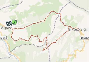
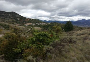
Trail Walking of 11.9 km to be discovered at Auvergne-Rhône-Alpes, Drôme, Arpavon. This trail is proposed by yveshumbert.
Description
Il faut se parquer au cimetière. Arpavon est un joli petit village avec des vieilles maisons. Le sentier suit la crête tout le début de la randonnée jusqu'à arriver au point culminant de la randonnée (833 m). On redescend un petit peu et le chemin continue à flanc. Le chemin est ensuite vallonné pour arriver au vieux village de Poët Sigillat. Pour le retour on retourne un peu sur ces pas et on emprunte un large chemin en descente.
Positioning
Comments
Trails nearby
![Trail Walking Sahune - 26 sahune - Photo](https://media.geolcdn.com/t/375/260/a180cf7c-fb96-48c2-9d7c-76f8ea234985.jpg&format=jpg&maxdim=2)
![Walking Walking](https://static1.geolcdn.com/sitytour/trail-icons/101.png)
Walking
![](/images/other/stat-length.png)
![](https://static1.geolcdn.com/siteimages/upload/files/16400158638029165_repeat_loop_refresh_sync_direction_icon.png)
![Trail Walking Sahune - rocher de Bramard - Photo](https://media.geolcdn.com/t/375/260/b6e96133-4660-4d7a-bbea-eb48a170bb19.jpg&format=jpg&maxdim=2)
![Walking Walking](https://static1.geolcdn.com/sitytour/trail-icons/101.png)
Walking
![](/images/other/stat-length.png)
![](https://static1.geolcdn.com/siteimages/upload/files/16400158638029165_repeat_loop_refresh_sync_direction_icon.png)
![Trail Walking Sahune - Sahune - Photo](https://media.geolcdn.com/t/375/260/ext.jpg?maxdim=2&url=https%3A%2F%2Fstatic1.geolcdn.com%2Fsiteimages%2Fupload%2Ffiles%2F1553511878bg_sport_marche.png)
![Walking Walking](https://static1.geolcdn.com/sitytour/trail-icons/101.png)
Walking
![](/images/other/stat-length.png)
![](https://static1.geolcdn.com/siteimages/upload/files/16400158638029165_repeat_loop_refresh_sync_direction_icon.png)
![Trail Road bike Sainte-Jalle - Col d’Ey depuis Sainte Jalle via Rochebrune - Photo](https://media.geolcdn.com/t/375/260/2d32934e-f0a5-4ec9-8fdb-ba37b4d45c7a.jpg&format=jpg&maxdim=2)
![Road bike Road bike](https://static1.geolcdn.com/sitytour/trail-icons/201.png)
Road bike
![](/images/other/stat-length.png)
![](https://static1.geolcdn.com/siteimages/upload/files/16400158638029165_repeat_loop_refresh_sync_direction_icon.png)
![Trail Walking Arpavon - BruBer-Arpavon : ND Consolation - Photo](https://media.geolcdn.com/t/375/260/ac6ca5aa-60a5-46e8-a1a6-5885958bb4b9.jpg&format=jpg&maxdim=2)
![Walking Walking](https://static1.geolcdn.com/sitytour/trail-icons/101.png)
Walking
![](/images/other/stat-length.png)
![](https://static1.geolcdn.com/siteimages/upload/files/16400158638029165_repeat_loop_refresh_sync_direction_icon.png)
![Trail Walking Sahune - Asptt SAHUNE VILLEPERDRIX - Photo](https://media.geolcdn.com/t/375/260/1db90b63-99dd-46d4-8a4a-760727bd6a27.jpg&format=jpg&maxdim=2)
![Walking Walking](https://static1.geolcdn.com/sitytour/trail-icons/101.png)
Walking
![](/images/other/stat-length.png)
![](https://static1.geolcdn.com/siteimages/upload/files/16400158638029165_repeat_loop_refresh_sync_direction_icon.png)
![Trail Walking Le Poët-Sigillat - poët Sigillat-col de Soubeyrand-Tarendol - Photo](https://media.geolcdn.com/t/375/260/62191b6d-cd1d-491d-b6a6-a8d2adebac5d.jpg&format=jpg&maxdim=2)
![Walking Walking](https://static1.geolcdn.com/sitytour/trail-icons/101.png)
Walking
![](/images/other/stat-length.png)
![](https://static1.geolcdn.com/siteimages/upload/files/16400158638029165_repeat_loop_refresh_sync_direction_icon.png)
![Trail Walking Montréal-les-Sources - Montréal les Sources 12km - Photo](https://media.geolcdn.com/t/375/260/85d16ab9-cc78-4106-9f58-44413d453253.jpg&format=jpg&maxdim=2)
![Walking Walking](https://static1.geolcdn.com/sitytour/trail-icons/101.png)
Walking
![](/images/other/stat-length.png)
![](https://static1.geolcdn.com/siteimages/upload/files/16400158638029165_repeat_loop_refresh_sync_direction_icon.png)
![Trail Walking Sainte-Jalle - GRP Baronnies Ste Jalle Arpavon 18km - Photo](https://media.geolcdn.com/t/375/260/8bd5c524-a80b-4e1f-b0f8-b1a379789e0d.jpg&format=jpg&maxdim=2)
![Walking Walking](https://static1.geolcdn.com/sitytour/trail-icons/101.png)
Walking
![](/images/other/stat-length.png)
![](https://static1.geolcdn.com/siteimages/upload/files/16400158638029165_repeat_loop_refresh_sync_direction_icon.png)