Trail On foot La Chapelle-de-Guinchay - 2022-11-29_134720 - Photo
 Bcomb
Bcomb

User

© OpenStreetMap contributors
Length
Length
9.4 km
Max alt
Max alt
276 m
Uphill gradient
Uphill gradient
109 m
Km-Effort
Km-Effort  
10.9 km
Min alt
Min alt
202 m
Downhill gradient
Downhill gradient
109 m
Boucle
Boucle
Yes
Creation date :
2022-12-02 08:50:09.625
Updated on :
2022-12-02 09:28:11.792

(0 Reviews)

On foot
On foot
2h28
Difficulty : Easy

Scan this QR Code to open this trail in the SityTrail application

FREE GPS app for hiking

Logo SityTrail SityTrail

IGN / Geographical institutes

Download SityTrail from the App Store Download SityTrail from Google Play

Logo SityTrail SityTrail World

The world is yours!

Download SityTrail from the App Store Download SityTrail from Google Play Download SityTrail on Huawei AppGallery

About

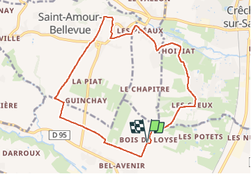
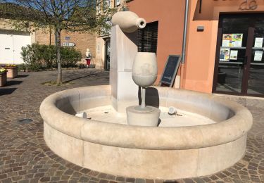
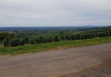
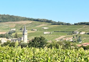
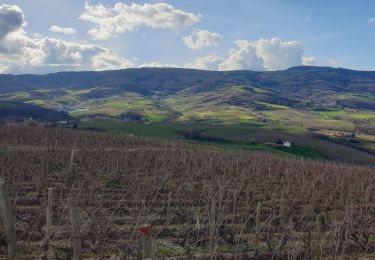
Trail On foot of 9.4 km to be discovered at Bourgogne-Franche-Comté, Saône-et-Loire, La Chapelle-de-Guinchay. This trail is proposed by Bcomb.

Description

Rando facile au départ du bois de Loyse à La Chapelle de Guinchay

Elevation profile

Positioning

Country:
France
Region :
Bourgogne-Franche-Comté
Department/Province :
Saône-et-Loire
Municipality :
La Chapelle-de-Guinchay
Location:
Unknown
Start:(UTM)
635892 ; 5120531 (31T) N.

Trails nearby

Trail Walking Chénas - Chénas - Le Venet - Photo
Walking
jipysn

Walking

Very easy
Chénas, Auvergne-Rhône-Alpes, Rhône, France
3.4 km | 4.5 km-effort
1h 1min
Yes
Trail Walking Leynes - LEYNES 71 - Photo
Walking
janussity

Walking

Difficult
Leynes, Bourgogne-Franche-Comté, Saône-et-Loire, France
9.5 km | 12.7 km-effort
2h 38min
Yes
Trail Walking Saint-Vérand - St Vérand - Photo
Walking
JPA GRS

Walking

Medium
(1)
Saint-Vérand, Bourgogne-Franche-Comté, Saône-et-Loire, France
9.8 km | 12.6 km-effort
2h 0min
Yes
Trail Walking Fleurie - les vignes de Fleurie - Photo
Walking
reneperrin

Walking

Easy
Fleurie, Auvergne-Rhône-Alpes, Rhône, France
8.1 km | 10.8 km-effort
2h 1min
Yes
Trail Walking Chaintré - Chantré  (Saône et Loire) - Photo
Walking
Thomasdanielle

Walking

Medium
Chaintré, Bourgogne-Franche-Comté, Saône-et-Loire, France
13.8 km | 18.5 km-effort
5h 37min
Yes
Trail Running Juliénas - jour 1 CAP Jeanot - Photo
Running
jeannat

Running

Very easy
Juliénas, Auvergne-Rhône-Alpes, Rhône, France
26 km | 38 km-effort
3h 41min
No
Trail Running Fleurie - Marathon Beaujolais - Photo
Running
zazie

Running

Medium
(1)
Fleurie, Auvergne-Rhône-Alpes, Rhône, France
43 km | 48 km-effort
4h 0min
No
Trail Walking Chénas - Chenas - Le Venet (2) - Photo
Walking
jipysn

Walking

Easy
Chénas, Auvergne-Rhône-Alpes, Rhône, France
5.7 km | 7.6 km-effort
1h 43min
Yes
Trail Walking Fleurie - Fleurie - Photo
Walking
janussity

Walking

Difficult
Fleurie, Auvergne-Rhône-Alpes, Rhône, France
11.4 km | 15.7 km-effort
2h 37min
Yes


Close
My subscriptions