Trail Walking Saint-Bohaire - St Bohaire AD - Photo
 christ41
christ41

User

© OpenStreetMap contributors
Length
Length
17 km
Max alt
Max alt
121 m
Uphill gradient
Uphill gradient
165 m
Km-Effort
Km-Effort  
19.2 km
Min alt
Min alt
86 m
Downhill gradient
Downhill gradient
167 m
Boucle
Boucle
No
Creation date :
2022-12-01 07:48:57.362
Updated on :
2022-12-01 11:31:49.063

(0 Reviews)

Walking
Walking
3h41
Difficulty : Easy

Scan this QR Code to open this trail in the SityTrail application

FREE GPS app for hiking

Logo SityTrail SityTrail

IGN / Geographical institutes

Download SityTrail from the App Store Download SityTrail from Google Play

Logo SityTrail SityTrail World

The world is yours!

Download SityTrail from the App Store Download SityTrail from Google Play Download SityTrail on Huawei AppGallery

About

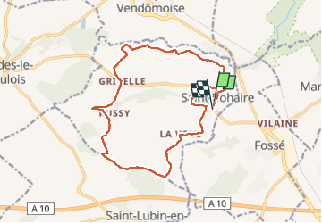
Trail Walking of 17 km to be discovered at Centre-Loire Valley, Loir-et-Cher, Saint-Bohaire. This trail is proposed by christ41.

Description

rando sans problème

Elevation profile

Positioning

Country:
France
Region :
Centre-Loire Valley
Department/Province :
Loir-et-Cher
Municipality :
Saint-Bohaire
Location:
Unknown
Start:(UTM)
369585 ; 5278249 (31T) N.

Trails nearby

Trail Walking Marolles - Site naturel et archéologique de la Grande Pierre et Vitain - Photo
Walking
guydu41

Walking

Medium
Marolles, Centre-Loire Valley, Loir-et-Cher, France
8.1 km | 9 km-effort
2h 2min
Yes
Trail Walking Fossé - Fossé - Photo
Walking
guydu41

Walking

Medium
Fossé, Centre-Loire Valley, Loir-et-Cher, France
9.1 km | 10.3 km-effort
2h 20min
Yes
Trail Walking Saint-Sulpice-de-Pommeray - Saint-Sulpice-de-Pommeray - Photo
Walking
guydu41

Walking

Medium
Saint-Sulpice-de-Pommeray, Centre-Loire Valley, Loir-et-Cher, France
24 km | 29 km-effort
8h 41min
Yes
Trail Walking Saint-Bohaire - Randonnée de Saint Notaire, reconnaissance BBR - Photo
Walking
Ecureuiltrailer

Walking

Very easy
Saint-Bohaire, Centre-Loire Valley, Loir-et-Cher, France
14.5 km | 16.7 km-effort
3h 2min
Yes
Trail Walking Marolles - Marolles loir et chet - Photo
Walking
frmarch

Walking

Very easy
Marolles, Centre-Loire Valley, Loir-et-Cher, France
10.1 km | 11 km-effort
2h 29min
Yes
Trail Walking Averdon - Averdon  - Photo
Walking
chantal hahusseau

Walking

Averdon, Centre-Loire Valley, Loir-et-Cher, France
14.3 km | 15.8 km-effort
3h 13min
Yes
Trail Walking Saint-Bohaire - St Bohaire  - Photo
Walking
chantal hahusseau

Walking

Saint-Bohaire, Centre-Loire Valley, Loir-et-Cher, France
14.4 km | 16.5 km-effort
3h 14min
Yes
Trail Walking Saint-Lubin-en-Vergonnois - saint lubin - Photo
Walking
gerardh

Walking

Medium
Saint-Lubin-en-Vergonnois, Centre-Loire Valley, Loir-et-Cher, France
9 km | 10.7 km-effort
2h 26min
Yes
Trail Other activity Saint-Lubin-en-Vergonnois - pierre - Photo
Other activity
pierredfr

Other activity

Very easy
Saint-Lubin-en-Vergonnois, Centre-Loire Valley, Loir-et-Cher, France
34 km | 39 km-effort
2h 17min
Yes


Close
My subscriptions