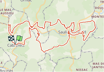
![](/images/other/stat-length.png)
![Trail Mountain bike Cabrerets - VTT Cabrerets 36km 1240 D+ 24 NOV 2022 - Photo](https://media.geolcdn.com/t/1900/400/ext.pjpeg?maxdim=2&url=https%3A%2F%2Fstatic1.geolcdn.com%2Fsiteimages%2Fupload%2Ffiles%2F1524743154velo.jpg)
VTT Cabrerets 36km 1240 D+ 24 NOV 2022
Levillefranchois
User
![Length](/images/other/stat-length.png)
![Max alt](https://static1.geolcdn.com/siteimages/upload/files/1508320355ic_sort_altitude_max_24dp.png)
![Uphill gradient](https://static1.geolcdn.com/siteimages/upload/files/1508320355ic_sort_den_pos_24dp.png)
![Km-Effort](/images/other/stat-length.png)
![Min alt](https://static1.geolcdn.com/siteimages/upload/files/1508320355ic_sort_altitude_min_24dp.png)
![Downhill gradient](https://static1.geolcdn.com/siteimages/upload/files/1508320355ic_sort_den_neg_24dp.png)
![Boucle](https://static1.geolcdn.com/siteimages/upload/files/16400158638029165_repeat_loop_refresh_sync_direction_icon.png)
![Mountain bike](https://static1.geolcdn.com/sitytour/trail-icons/202.png)
4h00
Difficulty : Difficult
![Scan this QR Code to open this trail in the SityTrail application](https://capi.geolives.com/qq0zvz2zws4bq2lad0pu/sitytour/trails/3465664/qr.png?size=200)
FREE GPS app for hiking
About
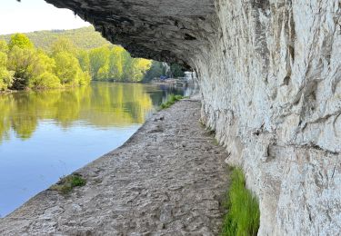
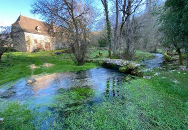
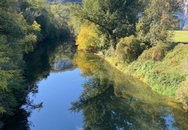
Trail Mountain bike of 35 km to be discovered at Occitania, Lot, Cabrerets. This trail is proposed by Levillefranchois.
Description
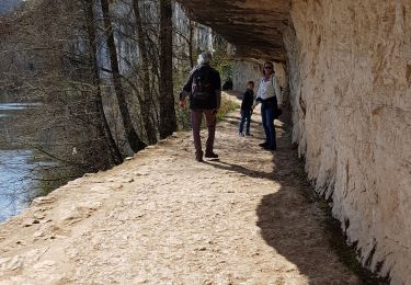
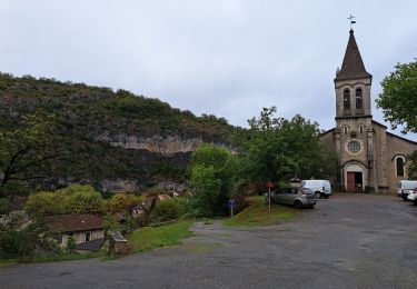
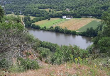
Parcours realisé en VTTAE, difficile par ses montées rudes et souvent techniques mais très beau par ses paysages traversés et ses points de vue. Il a été réalisé en automne apres des pluies, ce qui rend certains passages vraiment glissants et impose de descendre du vélo par prudence.
Une batterie de 500Wh est limite, il faut l'économiser au maximum.
Attention au niveau de Puech Redon, quand la trace ire au nord, il peut y avoir des clotures électriques a ouvrir et refermer et le sentier disparait dans ces pâtures.
PS. comme souvent remarqué, Sitytrail modifie à la baisse le dénivelé enregistré par mon gps-altimètre Garmin qui m'indiquait 1240D . D'ailleurs un autre utilisateur avait un gps indiquant 1420D ....
Positioning
Comments
Trails nearby
![Trail Walking Saint-Cirq-Lapopie - Circuit sud de St Cirq Lapopie - Photo](https://media.geolcdn.com/t/375/260/ext.jpg?maxdim=2&url=https%3A%2F%2Fservices.sitytrail.com%2FGeolivesWS%2FDownloadMedia.ashx%3FTrailID%3D136873%26Media%3D13540_3.jpg)
![Walking Walking](https://static1.geolcdn.com/sitytour/trail-icons/101.png)
Walking
![](/images/other/stat-length.png)
![](https://static1.geolcdn.com/siteimages/upload/files/16400158638029165_repeat_loop_refresh_sync_direction_icon.png)
![Trail Walking Bouziès - St Cirq Lapopie - Photo](https://media.geolcdn.com/t/375/260/44c160a2-93bf-4659-a751-61d8e3a0eb0e.jpg&format=jpg&maxdim=2)
![Walking Walking](https://static1.geolcdn.com/sitytour/trail-icons/101.png)
Walking
![](/images/other/stat-length.png)
![](https://static1.geolcdn.com/siteimages/upload/files/16400158638029165_repeat_loop_refresh_sync_direction_icon.png)
![Trail Walking Cabrerets - Etape 3 Cabrenets Bouziès St Cirq Bouziés - Photo](https://media.geolcdn.com/t/375/260/eb50dffb-c87e-4a9e-b7bf-cb556263d54c.jpg&format=jpg&maxdim=2)
![Walking Walking](https://static1.geolcdn.com/sitytour/trail-icons/101.png)
Walking
![](/images/other/stat-length.png)
![](https://static1.geolcdn.com/siteimages/upload/files/16400158638029165_repeat_loop_refresh_sync_direction_icon.png)
![Trail Walking Bouziès - Étape 4 Bouziès Les Mazuts - Photo](https://media.geolcdn.com/t/375/260/0fdee0ad-1a12-42b8-a827-ee8edec2f1aa.jpg&format=jpg&maxdim=2)
![Walking Walking](https://static1.geolcdn.com/sitytour/trail-icons/101.png)
Walking
![](/images/other/stat-length.png)
![](https://static1.geolcdn.com/siteimages/upload/files/16400158638029165_repeat_loop_refresh_sync_direction_icon.png)
![Trail Walking Cabrerets - Lot CABRERET BEARD - Photo](https://media.geolcdn.com/t/375/260/8fbbbeec-d494-492c-8bdb-b53bc7ff4969.jpg&format=jpg&maxdim=2)
![Walking Walking](https://static1.geolcdn.com/sitytour/trail-icons/101.png)
Walking
![](/images/other/stat-length.png)
![](https://static1.geolcdn.com/siteimages/upload/files/16400158638029165_repeat_loop_refresh_sync_direction_icon.png)
![Trail sport Saint-Cirq-Lapopie - 20240422 St Cirq - Vers - Photo](https://media.geolcdn.com/t/375/260/c7c2d083-3a15-4ad8-8255-9f2c2d891e51.jpg&format=jpg&maxdim=2)
sport
![](/images/other/stat-length.png)
![](https://static1.geolcdn.com/siteimages/upload/files/16400158638029165_repeat_loop_refresh_sync_direction_icon.png)
![Trail sport Cabrerets - 20240421 Cabrerets - St Cirq - Photo](https://media.geolcdn.com/t/375/260/d84c365c-9ae9-4395-be90-dbc8ee116e29.jpg&format=jpg&maxdim=2)
sport
![](/images/other/stat-length.png)
![](https://static1.geolcdn.com/siteimages/upload/files/16400158638029165_repeat_loop_refresh_sync_direction_icon.png)
![Trail Walking Cabrerets - Cabrerets Liauzu - Photo](https://media.geolcdn.com/t/375/260/9e8b98bf-3708-4f84-b612-7eff50bf29ed.jpg&format=jpg&maxdim=2)
![Walking Walking](https://static1.geolcdn.com/sitytour/trail-icons/101.png)
Walking
![](/images/other/stat-length.png)
![](https://static1.geolcdn.com/siteimages/upload/files/16400158638029165_repeat_loop_refresh_sync_direction_icon.png)
![Trail Walking Bouziès - Bouzies St Cirq Conduche - Photo](https://media.geolcdn.com/t/375/260/2aaa2ad3-04a4-48d5-bfb5-10fb0e32fe3f.jpg&format=jpg&maxdim=2)
![Walking Walking](https://static1.geolcdn.com/sitytour/trail-icons/101.png)
Walking
![](/images/other/stat-length.png)
![](https://static1.geolcdn.com/siteimages/upload/files/16400158638029165_repeat_loop_refresh_sync_direction_icon.png)