![](/images/other/stat-length.png)
![Trail Walking Saint-Philippe - vallée heureuse - Photo](https://media.geolcdn.com/t/1900/400/ext.pjpeg?maxdim=2&url=https%3A%2F%2Fstatic1.geolcdn.com%2Fsiteimages%2Fupload%2Ffiles%2F1553511878bg_sport_marche.png)
vallée heureuse
francejpp
User
![Length](/images/other/stat-length.png)
Length
21 km
![Max alt](https://static1.geolcdn.com/siteimages/upload/files/1508320355ic_sort_altitude_max_24dp.png)
Max alt
2271 m
![Uphill gradient](https://static1.geolcdn.com/siteimages/upload/files/1508320355ic_sort_den_pos_24dp.png)
Uphill gradient
1712 m
![Km-Effort](/images/other/stat-length.png)
Km-Effort
44 km
![Min alt](https://static1.geolcdn.com/siteimages/upload/files/1508320355ic_sort_altitude_min_24dp.png)
Min alt
584 m
![Downhill gradient](https://static1.geolcdn.com/siteimages/upload/files/1508320355ic_sort_den_neg_24dp.png)
Downhill gradient
1714 m
![Boucle](https://static1.geolcdn.com/siteimages/upload/files/16400158638029165_repeat_loop_refresh_sync_direction_icon.png)
Boucle
Yes
Creation date :
2016-03-09 00:00:00.0
Updated on :
2016-03-09 00:00:00.0
![Walking](https://static1.geolcdn.com/sitytour/trail-icons/101.png)
8h49
Difficulty : Difficult
![Scan this QR Code to open this trail in the SityTrail application](https://capi.geolives.com/qq0zvz2zws4bq2lad0pu/sitytour/trails/346327/qr.png?size=200)
FREE GPS app for hiking
About
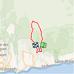
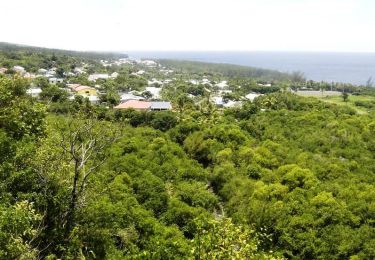
Trail Walking of 21 km to be discovered at Réunion, Unknown, Saint-Philippe. This trail is proposed by francejpp.
Description
depart Gite de basse Vallée
direction Piton Lardé surplombant la ravine basse vallée
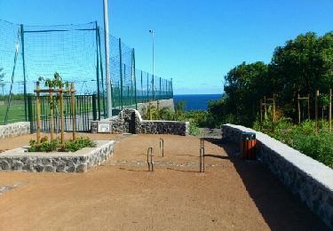
on rattrape le grr2 direction piton bois vert
direction Puys Ramond puis piton rick vers le point de départ
Positioning
Country:
France
Region :
Réunion
Department/Province :
Unknown
Municipality :
Saint-Philippe
Location:
Unknown
Start:(Dec)
Start:(UTM)
365287 ; 7639777 (40K) S.
Comments
Trails nearby
![Trail Walking Saint-Joseph - Cap Jaune randonnée famille - Photo](https://media.geolcdn.com/t/375/260/0eb20c45-f963-4b69-a85f-83e3bdaa6b80.jpg&format=jpg&maxdim=2)
![Walking Walking](https://static1.geolcdn.com/sitytour/trail-icons/101.png)
Cap Jaune randonnée famille
Walking
Very easy
Saint-Joseph,
Réunion,
Unknown,
France
![](/images/other/stat-length.png)
3.3 km | 4.4 km-effort
2h 0min
![](https://static1.geolcdn.com/siteimages/upload/files/16400158638029165_repeat_loop_refresh_sync_direction_icon.png)
Yes
![Trail Walking Saint-Philippe - sentiers botaniques - Photo](https://media.geolcdn.com/t/375/260/ext.jpg?maxdim=2&url=https%3A%2F%2Fservices.sitytrail.com%2FGeolivesWS%2FDownloadMedia.ashx%3FTrailID%3D232114%26Media%3Dfix__20131111125801.jpg)
![Walking Walking](https://static1.geolcdn.com/sitytour/trail-icons/101.png)
sentiers botaniques
Walking
Very easy
Saint-Philippe,
Réunion,
Unknown,
France
![](/images/other/stat-length.png)
4.2 km | 6.5 km-effort
1h 50min
![](https://static1.geolcdn.com/siteimages/upload/files/16400158638029165_repeat_loop_refresh_sync_direction_icon.png)
Yes
![Trail Walking Saint-Joseph - cap jaune - Photo](https://media.geolcdn.com/t/375/260/b1bf09be-09a9-4227-9178-69439bebcf69.jpg&format=jpg&maxdim=2)
![Walking Walking](https://static1.geolcdn.com/sitytour/trail-icons/101.png)
cap jaune
Walking
Very easy
Saint-Joseph,
Réunion,
Unknown,
France
![](/images/other/stat-length.png)
4.9 km | 6.6 km-effort
1h 18min
![](https://static1.geolcdn.com/siteimages/upload/files/16400158638029165_repeat_loop_refresh_sync_direction_icon.png)
Yes
![Trail Walking Saint-Philippe - GR® R2 Du gîte de Basse Vallée à Basse Vallée - Photo](https://media.geolcdn.com/t/375/260/ext.jpg?maxdim=2&url=https%3A%2F%2Fservices.sitytrail.com%2FGeolivesWS%2FDownloadMedia.ashx%3FTrailID%3D316702%26Media%3D3859_1.jpg)
![Walking Walking](https://static1.geolcdn.com/sitytour/trail-icons/101.png)
GR® R2 Du gîte de Basse Vallée à Basse Vallée
Walking
Medium
Saint-Philippe,
Réunion,
Unknown,
France
![](/images/other/stat-length.png)
5 km | 6.9 km-effort
2h 0min
![](https://static1.geolcdn.com/siteimages/upload/files/16400158638029165_repeat_loop_refresh_sync_direction_icon.png)
No
![Trail Walking Saint-Philippe - La Réunion - Boucle par le bord de mer de Basse Vallée (secteur St Philippe) - Photo](https://media.geolcdn.com/t/375/260/ext.jpg?maxdim=2&url=https%3A%2F%2Fservices.sitytrail.com%2FGeolivesWS%2FDownloadMedia.ashx%3FTrailID%3D258813%26Media%3Dfix__20140320160717.jpg)
![Walking Walking](https://static1.geolcdn.com/sitytour/trail-icons/101.png)
La Réunion - Boucle par le bord de mer de Basse Vallée (secteur St Philippe)
Walking
Very easy
Saint-Philippe,
Réunion,
Unknown,
France
![](/images/other/stat-length.png)
2.4 km | 2.9 km-effort
1h 2min
![](https://static1.geolcdn.com/siteimages/upload/files/16400158638029165_repeat_loop_refresh_sync_direction_icon.png)
Yes
![Trail Walking Saint-Philippe - La Réunion - Boucle par le sentier botanique de la forêt de Mare-Longue - Photo](https://media.geolcdn.com/t/375/260/ext.jpg?maxdim=2&url=https%3A%2F%2Fservices.sitytrail.com%2FGeolivesWS%2FDownloadMedia.ashx%3FTrailID%3D255672%26Media%3Dfix__20140309142644.jpg)
![Walking Walking](https://static1.geolcdn.com/sitytour/trail-icons/101.png)
La Réunion - Boucle par le sentier botanique de la forêt de Mare-Longue
Walking
Very easy
Saint-Philippe,
Réunion,
Unknown,
France
![](/images/other/stat-length.png)
2.4 km | 3.8 km-effort
1h 29min
![](https://static1.geolcdn.com/siteimages/upload/files/16400158638029165_repeat_loop_refresh_sync_direction_icon.png)
Yes
![Trail Walking Saint-Joseph - A/R Terre rouge, Le récif - Photo](https://media.geolcdn.com/t/375/260/ext.jpg?maxdim=2&url=https%3A%2F%2Fstatic1.geolcdn.com%2Fsiteimages%2Fupload%2Ffiles%2F1553511878bg_sport_marche.png)
![Walking Walking](https://static1.geolcdn.com/sitytour/trail-icons/101.png)
A/R Terre rouge, Le récif
Walking
Very easy
Saint-Joseph,
Réunion,
Unknown,
France
![](/images/other/stat-length.png)
5 km | 6.8 km-effort
1h 33min
![](https://static1.geolcdn.com/siteimages/upload/files/16400158638029165_repeat_loop_refresh_sync_direction_icon.png)
Yes
![Trail Walking Saint-Joseph - piton vincendo - cap poisson d'ail - Photo](https://media.geolcdn.com/t/375/260/ext.jpg?maxdim=2&url=https%3A%2F%2Fstatic1.geolcdn.com%2Fsiteimages%2Fupload%2Ffiles%2F1553511878bg_sport_marche.png)
![Walking Walking](https://static1.geolcdn.com/sitytour/trail-icons/101.png)
piton vincendo - cap poisson d'ail
Walking
Easy
Saint-Joseph,
Réunion,
Unknown,
France
![](/images/other/stat-length.png)
5.3 km | 7.2 km-effort
1h 30min
![](https://static1.geolcdn.com/siteimages/upload/files/16400158638029165_repeat_loop_refresh_sync_direction_icon.png)
Yes
![Trail sport Saint-Philippe - 2024-10-12_17h15m34_Randopitons Itineraire #1328 - Sentier Botanique Mare Longue Saint Philippe - Photo](https://media.geolcdn.com/t/375/260/ext.jpg?maxdim=2&url=https%3A%2F%2Fsecurestorage.geolives.com%2Fsitytour%2Ftrail-bg%2Fdefault.jpg)
2024-10-12_17h15m34_Randopitons Itineraire #1328 - Sentier Botanique Mare Lon...
sport
Very easy
Saint-Philippe,
Réunion,
Unknown,
France
![](/images/other/stat-length.png)
4.2 km | 6.8 km-effort
Unknown
![](https://static1.geolcdn.com/siteimages/upload/files/16400158638029165_repeat_loop_refresh_sync_direction_icon.png)
Yes