![](/images/other/stat-length.png)
VTT La Féclaz 25km
Levillefranchois
User
![Length](/images/other/stat-length.png)
Length
25 km
![Max alt](https://static1.geolcdn.com/siteimages/upload/files/1508320355ic_sort_altitude_max_24dp.png)
Max alt
1467 m
![Uphill gradient](https://static1.geolcdn.com/siteimages/upload/files/1508320355ic_sort_den_pos_24dp.png)
Uphill gradient
545 m
![Km-Effort](/images/other/stat-length.png)
Km-Effort
32 km
![Min alt](https://static1.geolcdn.com/siteimages/upload/files/1508320355ic_sort_altitude_min_24dp.png)
Min alt
1204 m
![Downhill gradient](https://static1.geolcdn.com/siteimages/upload/files/1508320355ic_sort_den_neg_24dp.png)
Downhill gradient
539 m
![Boucle](https://static1.geolcdn.com/siteimages/upload/files/16400158638029165_repeat_loop_refresh_sync_direction_icon.png)
Boucle
Yes
Creation date :
2022-11-17 10:44:44.601
Updated on :
2022-11-25 08:23:39.531
![Mountain bike](https://static1.geolcdn.com/sitytour/trail-icons/202.png)
2h12
Difficulty : Medium
![Scan this QR Code to open this trail in the SityTrail application](https://capi.geolives.com/qq0zvz2zws4bq2lad0pu/sitytour/trails/3459075/qr.png?size=200)
FREE GPS app for hiking
About
Trail Mountain bike of 25 km to be discovered at Auvergne-Rhône-Alpes, Savoy, Les Déserts. This trail is proposed by Levillefranchois.
Description
Boucle sur le plateau du Revard au départ de la station de La Féclaz.
Facile dans l'ensemble sauf quelques passages rocheux délicats peu apres le depart.
Positioning
Country:
France
Region :
Auvergne-Rhône-Alpes
Department/Province :
Savoy
Municipality :
Les Déserts
Location:
Unknown
Start:(Dec)
Start:(UTM)
732399 ; 5059330 (31T) N.
Comments
Trails nearby
![Trail Walking Montcel - BAUGES: TOUR DE LA FORET DOMANIALE DU GRAND REVARD - Photo](https://media.geolcdn.com/t/375/260/2b01686d-4589-4bde-9389-487a67061fc0.jpg&format=jpg&maxdim=2)
![Walking Walking](https://static1.geolcdn.com/sitytour/trail-icons/101.png)
BAUGES: TOUR DE LA FORET DOMANIALE DU GRAND REVARD
Walking
Difficult
(1)
Montcel,
Auvergne-Rhône-Alpes,
Savoy,
France
![](/images/other/stat-length.png)
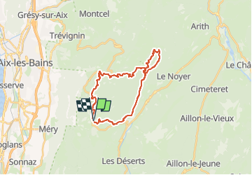
16.6 km | 24 km-effort
5h 15min
![](https://static1.geolcdn.com/siteimages/upload/files/16400158638029165_repeat_loop_refresh_sync_direction_icon.png)
Yes
![Trail Walking Les Déserts - golet de l'agneau - Photo](https://media.geolcdn.com/t/375/260/ext.jpg?maxdim=2&url=https%3A%2F%2Fservices.sitytrail.com%2FGeolivesWS%2FDownloadMedia.ashx%3FTrailID%3D229605%26Media%3Dfix__20131028144817.jpg)
![Walking Walking](https://static1.geolcdn.com/sitytour/trail-icons/101.png)
golet de l'agneau
Walking
Medium
(1)
Les Déserts,
Auvergne-Rhône-Alpes,
Savoy,
France
![](/images/other/stat-length.png)
3.9 km | 10.2 km-effort
1h 44min
![](https://static1.geolcdn.com/siteimages/upload/files/16400158638029165_repeat_loop_refresh_sync_direction_icon.png)
No
![Trail Walking Les Déserts - Circuit de la Croix Nivolet - Photo](https://media.geolcdn.com/t/375/260/ext.jpg?maxdim=2&url=https%3A%2F%2Fstatic1.geolcdn.com%2Fsiteimages%2Fupload%2Ffiles%2F1553511878bg_sport_marche.png)
![Walking Walking](https://static1.geolcdn.com/sitytour/trail-icons/101.png)
Circuit de la Croix Nivolet
Walking
Very easy
(1)
Les Déserts,
Auvergne-Rhône-Alpes,
Savoy,
France
![](/images/other/stat-length.png)
3.5 km | 5.6 km-effort
Unknown
![](https://static1.geolcdn.com/siteimages/upload/files/16400158638029165_repeat_loop_refresh_sync_direction_icon.png)
Yes
![Trail Walking Thoiry - le golet de l'agneau - Photo](https://media.geolcdn.com/t/375/260/95fcbe0f-c4e5-4eb2-ad04-6bb3c6835482.jpg&format=jpg&maxdim=2)
![Walking Walking](https://static1.geolcdn.com/sitytour/trail-icons/101.png)
le golet de l'agneau
Walking
Medium
Thoiry,
Auvergne-Rhône-Alpes,
Savoy,
France
![](/images/other/stat-length.png)
13.2 km | 26 km-effort
5h 20min
![](https://static1.geolcdn.com/siteimages/upload/files/16400158638029165_repeat_loop_refresh_sync_direction_icon.png)
Yes
![Trail Walking Montcel - BAUGES: PETIT TOUR DE LA FORET DOMANIALE DU REVARD - Photo](https://media.geolcdn.com/t/375/260/ext.jpg?maxdim=2&url=https%3A%2F%2Fstatic1.geolcdn.com%2Fsiteimages%2Fupload%2Ffiles%2F1553511878bg_sport_marche.png)
![Walking Walking](https://static1.geolcdn.com/sitytour/trail-icons/101.png)
BAUGES: PETIT TOUR DE LA FORET DOMANIALE DU REVARD
Walking
Medium
(1)
Montcel,
Auvergne-Rhône-Alpes,
Savoy,
France
![](/images/other/stat-length.png)
12.4 km | 17.2 km-effort
3h 30min
![](https://static1.geolcdn.com/siteimages/upload/files/16400158638029165_repeat_loop_refresh_sync_direction_icon.png)
Yes
![Trail Walking Mouxy - Sentier du Perthuiset - Photo](https://media.geolcdn.com/t/375/260/ext.jpg?maxdim=2&url=https%3A%2F%2Fstatic1.geolcdn.com%2Fsiteimages%2Fupload%2Ffiles%2F1553511878bg_sport_marche.png)
![Walking Walking](https://static1.geolcdn.com/sitytour/trail-icons/101.png)
Sentier du Perthuiset
Walking
Medium
(1)
Mouxy,
Auvergne-Rhône-Alpes,
Savoy,
France
![](/images/other/stat-length.png)
9.4 km | 19.9 km-effort
3h 19min
![](https://static1.geolcdn.com/siteimages/upload/files/16400158638029165_repeat_loop_refresh_sync_direction_icon.png)
Yes
![Trail Walking Les Déserts - Revard : La Féclaz - Photo](https://media.geolcdn.com/t/375/260/ext.jpg?maxdim=2&url=https%3A%2F%2Fstatic1.geolcdn.com%2Fsiteimages%2Fupload%2Ffiles%2F1553511878bg_sport_marche.png)
![Walking Walking](https://static1.geolcdn.com/sitytour/trail-icons/101.png)
Revard : La Féclaz
Walking
Easy
(1)
Les Déserts,
Auvergne-Rhône-Alpes,
Savoy,
France
![](/images/other/stat-length.png)
8.8 km | 10.6 km-effort
2h 22min
![](https://static1.geolcdn.com/siteimages/upload/files/16400158638029165_repeat_loop_refresh_sync_direction_icon.png)
Yes
![Trail Walking Montcel - La Culaz - Photo](https://media.geolcdn.com/t/375/260/6c40c4b5-435c-4557-a5f4-da8b6d9d2eb0.jpg&format=jpg&maxdim=2)
![Walking Walking](https://static1.geolcdn.com/sitytour/trail-icons/101.png)
La Culaz
Walking
Very difficult
Montcel,
Auvergne-Rhône-Alpes,
Savoy,
France
![](/images/other/stat-length.png)
15.7 km | 22 km-effort
6h 42min
![](https://static1.geolcdn.com/siteimages/upload/files/16400158638029165_repeat_loop_refresh_sync_direction_icon.png)
Yes
![Trail Walking Montcel - La Croix du Berger - Photo](https://media.geolcdn.com/t/375/260/f986dc09-993f-4c5c-ae42-1f703662732a.jpg&format=jpg&maxdim=2)
![Walking Walking](https://static1.geolcdn.com/sitytour/trail-icons/101.png)
La Croix du Berger
Walking
Medium
Montcel,
Auvergne-Rhône-Alpes,
Savoy,
France
![](/images/other/stat-length.png)
8.8 km | 11.7 km-effort
2h 39min
![](https://static1.geolcdn.com/siteimages/upload/files/16400158638029165_repeat_loop_refresh_sync_direction_icon.png)
Yes