Trail Walking Champlecy - 12/11/22 - Photo
© OpenStreetMap contributors
Length
Length
2.9 km
Max alt
Max alt
333 m
Uphill gradient
Uphill gradient
26 m
Km-Effort
Km-Effort  
3.2 km
Min alt
Min alt
316 m
Downhill gradient
Downhill gradient
32 m
Boucle
Boucle
No
Creation date :
2022-11-12 08:39:13.0
Updated on :
2022-11-12 11:28:45.175

(0 Reviews)

Walking
Walking
2h49
Difficulty : Easy

Scan this QR Code to open this trail in the SityTrail application

FREE GPS app for hiking

Logo SityTrail SityTrail

IGN / Geographical institutes

Download SityTrail from the App Store Download SityTrail from Google Play

Logo SityTrail SityTrail World

The world is yours!

Download SityTrail from the App Store Download SityTrail from Google Play Download SityTrail on Huawei AppGallery

About

Trail Walking of 2.9 km to be discovered at Bourgogne-Franche-Comté, Saône-et-Loire, Champlecy. This trail is proposed by Sasuke69us.

Description

12/11/22

Elevation profile

Positioning

Country:
France
Region :
Bourgogne-Franche-Comté
Department/Province :
Saône-et-Loire
Municipality :
Champlecy
Location:
Unknown
Start:(UTM)
593905 ; 5144152 (31T) N.

Trails nearby

Trail Mountain bike Champlecy - VTT autour de Champlecy - Photo
Mountain bike
tracegps

Mountain bike

Easy
Champlecy, Bourgogne-Franche-Comté, Saône-et-Loire, France
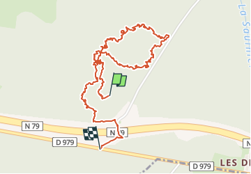
26 km | 31 km-effort
2h 19min
Yes
Trail Mountain bike Charolles - 5ème Marche du Boeuf 2012 VTT  25km - Charolles - Photo
Mountain bike
tracegps

Mountain bike

Medium
Charolles, Bourgogne-Franche-Comté, Saône-et-Loire, France
28 km | 34 km-effort
2h 30min
Yes
Trail Walking Champlecy - champlecy - Photo
Walking

Walking

Difficult
Champlecy, Bourgogne-Franche-Comté, Saône-et-Loire, France
10.5 km | 12.6 km-effort
2h 35min
Yes
Trail Walking Champlecy - champlecy - Photo
Walking
Malice0093

Walking

Difficult
Champlecy, Bourgogne-Franche-Comté, Saône-et-Loire, France
11.2 km | 13.3 km-effort
3h 1min
Yes
Trail Other activity Charolles - rondje charolles - Photo
Other activity
fritsaubin

Other activity

Easy
Charolles, Bourgogne-Franche-Comté, Saône-et-Loire, France
6.7 km | 8.1 km-effort
1h 38min
Yes
Trail Walking Hautefond - Lugny les charolles voie ferrée  - Photo
Walking
denis alloin

Walking

Hautefond, Bourgogne-Franche-Comté, Saône-et-Loire, France
1.8 km | 2 km-effort
1h 6min
Yes
Trail Walking Charolles - charolles - Photo
Walking
darancette

Walking

Easy
Charolles, Bourgogne-Franche-Comté, Saône-et-Loire, France
3.9 km | 4.7 km-effort
1h 0min
Yes
Trail Walking Changy - changy tourny - Photo
Walking

Walking

Very difficult
(1)
Changy, Bourgogne-Franche-Comté, Saône-et-Loire, France
19.1 km | 24 km-effort
5h 33min
Yes
Trail Walking Champlecy - Champlecy - Photo
Walking
Bonnefois Bernard

Walking

Champlecy, Bourgogne-Franche-Comté, Saône-et-Loire, France
5 km | 6 km-effort
1h 46min
Yes


Close
My subscriptions