Trail Walking Cette-Eygun - Cette: Cabane de Sabas et col de Pène Blanque - Photo

Cette: Cabane de Sabas et col de Pène Blanque

 bedous
bedous

User

© OpenStreetMap contributors
Length
Length
6.8 km
Max alt
Max alt
1158 m
Uphill gradient
Uphill gradient
537 m
Km-Effort
Km-Effort  
14 km
Min alt
Min alt
688 m
Downhill gradient
Downhill gradient
542 m
Boucle
Boucle
Yes
Creation date :
2022-11-11 08:57:30.545
Updated on :
2022-11-11 15:03:43.733

(0 Reviews)

Walking
Walking
3h32
Difficulty : Difficult

Scan this QR Code to open this trail in the SityTrail application

FREE GPS app for hiking

Logo SityTrail SityTrail

IGN / Geographical institutes

Download SityTrail from the App Store Download SityTrail from Google Play

Logo SityTrail SityTrail World

The world is yours!

Download SityTrail from the App Store Download SityTrail from Google Play Download SityTrail on Huawei AppGallery

About

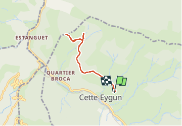
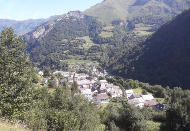
Trail Walking of 6.8 km to be discovered at New Aquitaine, Pyrénées-Atlantiques, Cette-Eygun. This trail is proposed by bedous.

Description

De fortes rampes mais pour bénéficier de magnifiques vues du cirque de Lescun et de la vallée qui monte vers le Somport.

Elevation profile

Photos

Positioning

Country:
France
Region :
New Aquitaine
Department/Province :
Pyrénées-Atlantiques
Municipality :
Cette-Eygun
Location:
Unknown
Start:(UTM)
696989 ; 4756812 (30T) N.

Trails nearby

Trail On foot Accous - Sommet du Poey asp122 - Photo
On foot
GUIDE+

On foot

Easy
Accous, New Aquitaine, Pyrénées-Atlantiques, France
3.5 km | 5.7 km-effort
1h 17min
Yes
Trail On foot Cette-Eygun - Granges de Cette asp56 - Photo
On foot
GUIDE+

On foot

Easy
Cette-Eygun, New Aquitaine, Pyrénées-Atlantiques, France
5.4 km | 10.2 km-effort
2h 18min
Yes
Trail On foot Cette-Eygun - Cabane de Lhèze asp116 - Photo
On foot
GUIDE+

On foot

Easy
Cette-Eygun, New Aquitaine, Pyrénées-Atlantiques, France
3.6 km | 9.7 km-effort
2h 11min
No
Trail On foot Cette-Eygun - Cabanes de Narbèze asp117 - Photo
On foot
GUIDE+

On foot

Easy
Cette-Eygun, New Aquitaine, Pyrénées-Atlantiques, France
6.5 km | 16.6 km-effort
3h 45min
No
Trail On foot Cette-Eygun - Tour de Lasies asp115 - Photo
On foot
GUIDE+

On foot

Easy
Cette-Eygun, New Aquitaine, Pyrénées-Atlantiques, France
4.3 km | 8.7 km-effort
1h 59min
No
Trail On foot Etsaut - Chemin de Beloute asp118 - Photo
On foot
GUIDE+

On foot

Easy
Etsaut, New Aquitaine, Pyrénées-Atlantiques, France
3.1 km | 8.3 km-effort
1h 53min
No
Trail On foot Borce - Tour du Bialaa asp63 - Photo
On foot
GUIDE+

On foot

Easy
Borce, New Aquitaine, Pyrénées-Atlantiques, France
3.7 km | 7.9 km-effort
1h 47min
No
Trail On foot Borce - Tour d'Ayriré par Udapet asp64 - Photo
On foot
GUIDE+

On foot

Easy
Borce, New Aquitaine, Pyrénées-Atlantiques, France
5.2 km | 13.2 km-effort
2h 59min
No
Trail On foot Borce - Sentier de Borce à Belonce PNP - Photo
On foot
GUIDE+

On foot

Easy
Borce, New Aquitaine, Pyrénées-Atlantiques, France
6.4 km | 11.3 km-effort
2h 33min
No


Close
My subscriptions