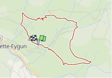
Trail Walking Cette-Eygun - Chemin d'Arna - Photo
 bedous
bedous

User

© OpenStreetMap contributors
Length
Length
5.4 km
Max alt
Max alt
1041 m
Uphill gradient
Uphill gradient
351 m
Km-Effort
Km-Effort  
10.1 km
Min alt
Min alt
687 m
Downhill gradient
Downhill gradient
357 m
Boucle
Boucle
Yes
Creation date :
2022-11-08 08:22:03.836
Updated on :
2022-11-09 09:57:58.122

(1 Reviews)

Walking
Walking
1h58
Difficulty : Medium

Scan this QR Code to open this trail in the SityTrail application

FREE GPS app for hiking

Logo SityTrail SityTrail

IGN / Geographical institutes

Download SityTrail from the App Store Download SityTrail from Google Play

Logo SityTrail SityTrail World

The world is yours!

Download SityTrail from the App Store Download SityTrail from Google Play Download SityTrail on Huawei AppGallery

About

Trail Walking of 5.4 km to be discovered at New Aquitaine, Pyrénées-Atlantiques, Cette-Eygun. This trail is proposed by bedous.

Description

Superbe randonnée sur le haut de Cette. Une grande partie de la rando se déroule sous les arbres ( trés adréable) sauf la partie sud avec un fort dénivelé sur une 1 kilimètre.
A effectuer dans le sens des aiguilles.

Elevation profile

Positioning

Country:
France
Region :
New Aquitaine
Department/Province :
Pyrénées-Atlantiques
Municipality :
Cette-Eygun
Location:
Unknown
Start:(UTM)
697212 ; 4756693 (30T) N.

Comments

Please log in to post a review or rate the element


Trails nearby

Trail Walking Etsaut - CHEMIN DE LA MATURE - Photo
Walking
PVERTICAL

Walking

Medium
(2)
Etsaut, New Aquitaine, Pyrénées-Atlantiques, France
8.8 km | 18.6 km-effort
3h 25min
Yes
Trail Walking Etsaut - Chemin de la Mâture en vallée d'Aspe - Photo
Walking
tracegps

Walking

Difficult
(1)
Etsaut, New Aquitaine, Pyrénées-Atlantiques, France
7.5 km | 16.8 km-effort
4h 0min
Yes
Trail On foot Accous - Sommet du Poey asp122 - Photo
On foot
GUIDE+

On foot

Easy
Accous, New Aquitaine, Pyrénées-Atlantiques, France
3.5 km | 5.7 km-effort
1h 17min
Yes
Trail On foot Cette-Eygun - Granges de Cette asp56 - Photo
On foot
GUIDE+

On foot

Easy
Cette-Eygun, New Aquitaine, Pyrénées-Atlantiques, France
5.4 km | 10.2 km-effort
2h 18min
Yes
Trail On foot Cette-Eygun - Cabane de Lhèze asp116 - Photo
On foot
GUIDE+

On foot

Easy
Cette-Eygun, New Aquitaine, Pyrénées-Atlantiques, France
3.6 km | 9.7 km-effort
2h 11min
No
Trail On foot Cette-Eygun - Cabanes de Narbèze asp117 - Photo
On foot
GUIDE+

On foot

Easy
Cette-Eygun, New Aquitaine, Pyrénées-Atlantiques, France
6.5 km | 16.6 km-effort
3h 45min
No
Trail On foot Cette-Eygun - Tour de Lasies asp115 - Photo
On foot
GUIDE+

On foot

Easy
Cette-Eygun, New Aquitaine, Pyrénées-Atlantiques, France
4.3 km | 8.7 km-effort
1h 59min
No
Trail On foot Etsaut - Chemin de Beloute asp118 - Photo
On foot
GUIDE+

On foot

Easy
Etsaut, New Aquitaine, Pyrénées-Atlantiques, France
3.1 km | 8.3 km-effort
1h 53min
No
Trail On foot Borce - Tour du Bialaa asp63 - Photo
On foot
GUIDE+

On foot

Easy
Borce, New Aquitaine, Pyrénées-Atlantiques, France
3.7 km | 7.9 km-effort
1h 47min
No


Close
My subscriptions