Trail Mountain bike Martiel - martiel 52 - Photo
© OpenStreetMap contributors
Length
Length
53 km
Max alt
Max alt
401 m
Uphill gradient
Uphill gradient
971 m
Km-Effort
Km-Effort  
66 km
Min alt
Min alt
158 m
Downhill gradient
Downhill gradient
969 m
Boucle
Boucle
Yes
Creation date :
2014-12-10 00:00:00.0
Updated on :
2014-12-10 00:00:00.0

(1 Reviews)

Mountain bike
Mountain bike
4h23
Difficulty : Difficult

Scan this QR Code to open this trail in the SityTrail application

FREE GPS app for hiking

Logo SityTrail SityTrail

IGN / Geographical institutes

Download SityTrail from the App Store Download SityTrail from Google Play

Logo SityTrail SityTrail World

The world is yours!

Download SityTrail from the App Store Download SityTrail from Google Play Download SityTrail on Huawei AppGallery

About

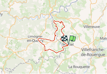
Trail Mountain bike of 53 km to be discovered at Occitania, Aveyron, Martiel. This trail is proposed by Gerard_Soulie.

Elevation profile

Positioning

Country:
France
Region :
Occitania
Department/Province :
Aveyron
Municipality :
Martiel
Location:
Unknown
Start:(UTM)
414247 ; 4914136 (31T) N.

Comments

Please log in to post a review or rate the element


Circuit très roulant dans les 2 premiers tiers, une descente difficile (200m) puis remontée sur Anglars dure (poser le pied pourquoi pas). Belle descente sur le Gouffre de Lantouy que l'on va laisser à gauche en bas. On suit la D146 sur 1.5 km... souffler car les difficultés arrivent. Prendre à gauche un chemin pentu, rocailleux parfois jusqu'à Laval. On peut aussi poser le pied. Après Laval on prend à gauche un chemin qui descend et nous amène à suivre le lit du ruisseau de Soubeyre. Chemin splendide presque une piste, et des buis magnifiques de tous côtés. Quelques belles flaques boueuses... attention en hiver. Et on remonte sur le plateau, on laisse St Clair à gauche et on prend des chemins sans difficultés particulières vers le bois de Margues et ses dolmens. On atteint vite Marroule, on longe la D911 jusqu'à Martiel. Ouf on est arrivé un peu sur les genoux. Dernier tiers très difficile car on a déjà 35 km dans les pattes! Mais des paysages hors du commun, de belles maisons, des garriotes et le silence. Noter : peu de goudron.


Trails nearby

Trail Walking Martiel - Circuit du Lac de Bannac - Martiel - Photo
Walking
tracegps

Walking

Medium
(1)
Martiel, Occitania, Aveyron, France
21 km | 25 km-effort
5h 30min
Yes
Trail Walking Laramière - Fonteynous - Tour du lac de Bannac - Photo
Walking
clotioneb

Walking

Very easy
(1)
Laramière, Occitania, Lot, France
4.5 km | 5.2 km-effort
1h 16min
Yes
Trail Walking Laramière - Lac de Bannac - Photo
Walking
clotioneb

Walking

Very easy
Laramière, Occitania, Lot, France
4.2 km | 4.8 km-effort
1h 23min
Yes
Trail Walking Martiel - Boucle des dolmens de Martiel - Photo
Walking
tracegps

Walking

Medium
(1)
Martiel, Occitania, Aveyron, France
9.4 km | 11.2 km-effort
2h 0min
Yes
Trail Walking Laramière - tour du lac de Bannac - Photo
Walking
clotioneb

Walking

Very easy
Laramière, Occitania, Lot, France
17.1 km | 19.7 km-effort
5h 5min
No
Trail Walking Martiel - tour du lac de Bannac - Photo
Walking
leglisemichel

Walking

Easy
Martiel, Occitania, Aveyron, France
4.8 km | 5.4 km-effort
1h 14min
Yes
Trail Walking Laramière - vidaillac _reco - Photo
Walking
turbo33

Walking

Difficult
Laramière, Occitania, Lot, France
10.5 km | 12.4 km-effort
2h 27min
No
Trail Walking Martiel - circuit des fontaines martiell - Photo
Walking
Sylvie camacho

Walking

Easy
Martiel, Occitania, Aveyron, France
13.3 km | 15.7 km-effort
2h 52min
No
Trail Mountain bike Puyjourdes - vtt criterium 2020 - Photo
Mountain bike
vialette

Mountain bike

Easy
Puyjourdes, Occitania, Lot, France
13.8 km | 16.9 km-effort
1h 7min
Yes


Close
My subscriptions