![](/images/other/stat-length.png)
Voie verte, voie ferrée, Bastide Neuve, Les Michels, retour par GRP.
ericberlin
User
![Length](/images/other/stat-length.png)
Length
10.6 km
![Max alt](https://static1.geolcdn.com/siteimages/upload/files/1508320355ic_sort_altitude_max_24dp.png)
Max alt
327 m
![Uphill gradient](https://static1.geolcdn.com/siteimages/upload/files/1508320355ic_sort_den_pos_24dp.png)
Uphill gradient
188 m
![Km-Effort](/images/other/stat-length.png)
Km-Effort
13.1 km
![Min alt](https://static1.geolcdn.com/siteimages/upload/files/1508320355ic_sort_altitude_min_24dp.png)
Min alt
213 m
![Downhill gradient](https://static1.geolcdn.com/siteimages/upload/files/1508320355ic_sort_den_neg_24dp.png)
Downhill gradient
186 m
![Boucle](https://static1.geolcdn.com/siteimages/upload/files/16400158638029165_repeat_loop_refresh_sync_direction_icon.png)
Boucle
Yes
Creation date :
2022-11-06 16:27:40.908
Updated on :
2022-11-06 16:40:15.562
![Walking](https://static1.geolcdn.com/sitytour/trail-icons/101.png)
2h58
Difficulty : Difficult
![Mountain bike](https://static1.geolcdn.com/sitytour/trail-icons/202.png)
54m
Difficulty : Easy
![Scan this QR Code to open this trail in the SityTrail application](https://capi.geolives.com/qq0zvz2zws4bq2lad0pu/sitytour/trails/3448320/qr.png?size=200)
FREE GPS app for hiking
About
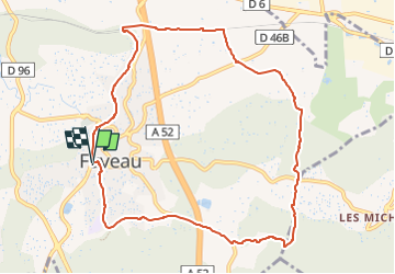
Trail Walking of 10.6 km to be discovered at Provence-Alpes-Côte d'Azur, Bouches-du-Rhône, Fuveau. This trail is proposed by ericberlin.
Description
à tester
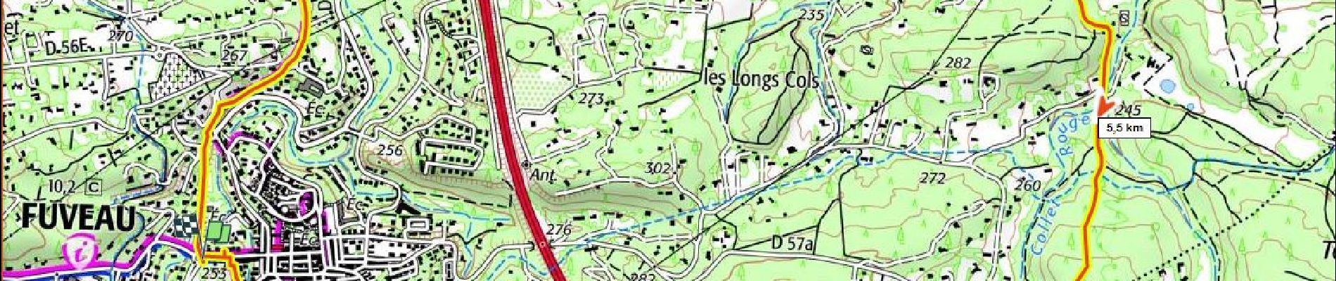
passage sur l'autoroute par la voie ferrée de Trets.
retour par GRP "Energies"
variante: retour par la chapelle St Michel.
Positioning
Country:
France
Region :
Provence-Alpes-Côte d'Azur
Department/Province :
Bouches-du-Rhône
Municipality :
Fuveau
Location:
Unknown
Start:(Dec)
Start:(UTM)
706991 ; 4814356 (31T) N.
Comments
Trails nearby
![Mountain bike Mountain bike](https://static1.geolcdn.com/sitytour/trail-icons/202.png)
Le Regagnas par Belcodène retour par Kirbon et Les Michels D+715m
Mountain bike
Very difficult
(1)
Fuveau,
Provence-Alpes-Côte d'Azur,
Bouches-du-Rhône,
France
![](/images/other/stat-length.png)
33 km | 43 km-effort
2h 59min
![](https://static1.geolcdn.com/siteimages/upload/files/16400158638029165_repeat_loop_refresh_sync_direction_icon.png)
Yes
![Walking Walking](https://static1.geolcdn.com/sitytour/trail-icons/101.png)
Canal par le chemin de fer
Walking
Very difficult
(1)
Fuveau,
Provence-Alpes-Côte d'Azur,
Bouches-du-Rhône,
France
![](/images/other/stat-length.png)
16.8 km | 21 km-effort
4h 40min
![](https://static1.geolcdn.com/siteimages/upload/files/16400158638029165_repeat_loop_refresh_sync_direction_icon.png)
Yes
![Mountain bike Mountain bike](https://static1.geolcdn.com/sitytour/trail-icons/202.png)
La corniche des 2 barrages de Ste Victoire
Mountain bike
Very difficult
(1)
Fuveau,
Provence-Alpes-Côte d'Azur,
Bouches-du-Rhône,
France
![](/images/other/stat-length.png)
35 km | 45 km-effort
3h 7min
![](https://static1.geolcdn.com/siteimages/upload/files/16400158638029165_repeat_loop_refresh_sync_direction_icon.png)
Yes
![Road bike Road bike](https://static1.geolcdn.com/sitytour/trail-icons/201.png)
Vallée de l'Arc et retour par Pourrières Puyloubier Chateauneuf
Road bike
Very difficult
(1)
Fuveau,
Provence-Alpes-Côte d'Azur,
Bouches-du-Rhône,
France
![](/images/other/stat-length.png)
42 km | 47 km-effort
2h 52min
![](https://static1.geolcdn.com/siteimages/upload/files/16400158638029165_repeat_loop_refresh_sync_direction_icon.png)
Yes
![Mountain bike Mountain bike](https://static1.geolcdn.com/sitytour/trail-icons/202.png)
4 Termes, Chateau-bas, Siminane, Pilon, Col St-Anne, Mimet, Gréasque
Mountain bike
Very difficult
(1)
Fuveau,
Provence-Alpes-Côte d'Azur,
Bouches-du-Rhône,
France
![](/images/other/stat-length.png)
36 km | 47 km-effort
3h 13min
![](https://static1.geolcdn.com/siteimages/upload/files/16400158638029165_repeat_loop_refresh_sync_direction_icon.png)
Yes
![Walking Walking](https://static1.geolcdn.com/sitytour/trail-icons/101.png)
La centrale photovoltaique par le chemin de fer
Walking
Difficult
(1)
Fuveau,
Provence-Alpes-Côte d'Azur,
Bouches-du-Rhône,
France
![](/images/other/stat-length.png)
10.1 km | 12.6 km-effort
2h 52min
![](https://static1.geolcdn.com/siteimages/upload/files/16400158638029165_repeat_loop_refresh_sync_direction_icon.png)
Yes
![Road bike Road bike](https://static1.geolcdn.com/sitytour/trail-icons/201.png)
Tour Ste Victoire D+1200m
Road bike
Very difficult
(1)
Fuveau,
Provence-Alpes-Côte d'Azur,
Bouches-du-Rhône,
France
![](/images/other/stat-length.png)
72 km | 88 km-effort
5h 21min
![](https://static1.geolcdn.com/siteimages/upload/files/16400158638029165_repeat_loop_refresh_sync_direction_icon.png)
Yes
![Mountain bike Mountain bike](https://static1.geolcdn.com/sitytour/trail-icons/202.png)
Fuveau, Regagnas, La Couelle, Kirbon, Les Michels, Fuveau D+790m
Mountain bike
Very difficult
(1)
Fuveau,
Provence-Alpes-Côte d'Azur,
Bouches-du-Rhône,
France
![](/images/other/stat-length.png)
38 km | 49 km-effort
3h 24min
![](https://static1.geolcdn.com/siteimages/upload/files/16400158638029165_repeat_loop_refresh_sync_direction_icon.png)
Yes
![Road bike Road bike](https://static1.geolcdn.com/sitytour/trail-icons/201.png)
Maison de la Ste Victoire D+590m
Road bike
Very difficult
(1)
Fuveau,
Provence-Alpes-Côte d'Azur,
Bouches-du-Rhône,
France
![](/images/other/stat-length.png)
36 km | 44 km-effort
2h 40min
![](https://static1.geolcdn.com/siteimages/upload/files/16400158638029165_repeat_loop_refresh_sync_direction_icon.png)
Yes