![](/images/other/stat-length.png)
![Trail Walking Savignac-Lédrier - Pont Suspendu sur l'Auvézère – Cascade de Saut Ruban cm - Photo](https://media.geolcdn.com/t/1900/400/ext.pjpeg?maxdim=2&url=https%3A%2F%2Fstatic1.geolcdn.com%2Fsiteimages%2Fupload%2Ffiles%2F1553511878bg_sport_marche.png)
Pont Suspendu sur l'Auvézère – Cascade de Saut Ruban cm
houbart
User
![Length](/images/other/stat-length.png)
![Max alt](https://static1.geolcdn.com/siteimages/upload/files/1508320355ic_sort_altitude_max_24dp.png)
![Uphill gradient](https://static1.geolcdn.com/siteimages/upload/files/1508320355ic_sort_den_pos_24dp.png)
![Km-Effort](/images/other/stat-length.png)
![Min alt](https://static1.geolcdn.com/siteimages/upload/files/1508320355ic_sort_altitude_min_24dp.png)
![Downhill gradient](https://static1.geolcdn.com/siteimages/upload/files/1508320355ic_sort_den_neg_24dp.png)
![Boucle](https://static1.geolcdn.com/siteimages/upload/files/16400158638029165_repeat_loop_refresh_sync_direction_icon.png)
![Walking](https://static1.geolcdn.com/sitytour/trail-icons/101.png)
4h31
Difficulty : Very difficult
![Scan this QR Code to open this trail in the SityTrail application](https://capi.geolives.com/qq0zvz2zws4bq2lad0pu/sitytour/trails/3448030/qr.png?size=200)
FREE GPS app for hiking
About
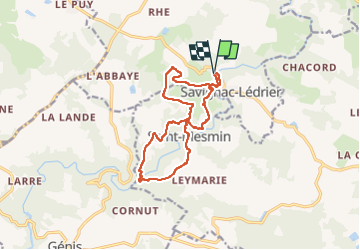
Trail Walking of 13.9 km to be discovered at New Aquitaine, Dordogne, Savignac-Lédrier. This trail is proposed by houbart.
Description
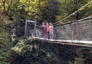
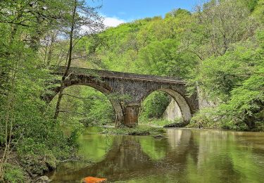
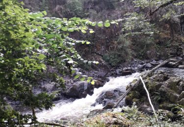
Jour 5 point de départ au pied des anciennes forges de Savignac avec quelques reflets sur l'écluse. Quelques pas nous dirigent vers la rivière, une descente prévue sur un sentier bien pavé, un tête en l'air 😴est passée ailleurs. Un lit de torrent sur lequel ai apprécié les cordes, qui débouchent sur la première passerelle. Une fois franchie, les bords de rivière, ses rocaille et racines vous guident vers les sommets⛰. Une roulotte vous invite à la pause, une petite église au passage et on redescend sur les sentiers de rocaille, excellent massage de chevilles😅. La belle cascade est au bout des cailloux. Deuxième passerelle et on remontent évidement sur la caillasse et là pas de corde🤣. La chienne toujours devant, ai fait comme elle, à quatre pattes😅.
Les chemins du retour nous ont conduit sur l'autre rives des Forges, avec son parcours thématique, instructif.
Positioning
Comments
Trails nearby
![Trail Walking Saint-Mesmin - DORDOGNE / SAINT MESMIN: L' AUVEZERE - Photo](https://media.geolcdn.com/t/375/260/a51290cc-5dca-4fd0-999c-e380f6500600.jpg&format=jpg&maxdim=2)
![Walking Walking](https://static1.geolcdn.com/sitytour/trail-icons/101.png)
Walking
![](/images/other/stat-length.png)
![](https://static1.geolcdn.com/siteimages/upload/files/16400158638029165_repeat_loop_refresh_sync_direction_icon.png)
![Trail On foot Saint-Mesmin - Boucle du Gabourat - Photo](https://media.geolcdn.com/t/375/260/2112195b-85eb-477d-827c-629d08f3c4ea.jpeg&format=jpg&maxdim=2)
![On foot On foot](https://static1.geolcdn.com/sitytour/trail-icons/100.png)
On foot
![](/images/other/stat-length.png)
![](https://static1.geolcdn.com/siteimages/upload/files/16400158638029165_repeat_loop_refresh_sync_direction_icon.png)
![Trail Walking Saint-Mesmin - St Mesmin - Photo](https://media.geolcdn.com/t/375/260/edc36c68-ee92-44b9-92ee-54b159e8845d.jpg&format=jpg&maxdim=2)
![Walking Walking](https://static1.geolcdn.com/sitytour/trail-icons/101.png)
Walking
![](/images/other/stat-length.png)
![](https://static1.geolcdn.com/siteimages/upload/files/16400158638029165_repeat_loop_refresh_sync_direction_icon.png)
![Trail Walking Angoisse - Le bois de Rouffiac - Lanouaille - Photo](https://media.geolcdn.com/t/375/260/ext.jpg?maxdim=2&url=https%3A%2F%2Fservices.sitytrail.com%2FGeolivesWS%2FDownloadMedia.ashx%3FTrailID%3D172637%26Media%3D14006_3.jpg)
![Walking Walking](https://static1.geolcdn.com/sitytour/trail-icons/101.png)
Walking
![](/images/other/stat-length.png)
![](https://static1.geolcdn.com/siteimages/upload/files/16400158638029165_repeat_loop_refresh_sync_direction_icon.png)
![Trail Mountain bike Savignac-Lédrier - Sentier Les Bruyères du Puy des Ages à Savignac-Lédrier - Photo](https://media.geolcdn.com/t/375/260/ext.jpg?maxdim=2&url=https%3A%2F%2Fservices.sitytrail.com%2FGeolivesWS%2FDownloadMedia.ashx%3FTrailID%3D112558%26Media%3D10837_6.jpg)
![Mountain bike Mountain bike](https://static1.geolcdn.com/sitytour/trail-icons/202.png)
Mountain bike
![](/images/other/stat-length.png)
![](https://static1.geolcdn.com/siteimages/upload/files/16400158638029165_repeat_loop_refresh_sync_direction_icon.png)
![Trail Walking Savignac-Lédrier - Sentier Les Bruyères du Puy des Ages à Savignac-Lédrier - Photo](https://media.geolcdn.com/t/375/260/ext.jpg?maxdim=2&url=https%3A%2F%2Fservices.sitytrail.com%2FGeolivesWS%2FDownloadMedia.ashx%3FTrailID%3D112557%26Media%3D10837_6.jpg)
![Walking Walking](https://static1.geolcdn.com/sitytour/trail-icons/101.png)
Walking
![](/images/other/stat-length.png)
![](https://static1.geolcdn.com/siteimages/upload/files/16400158638029165_repeat_loop_refresh_sync_direction_icon.png)
![Trail Walking Génis - Rand'Auvezere - Photo](https://media.geolcdn.com/t/375/260/bdcd3d06-cbea-46a9-b180-c7c5bb9d4a09.jpg&format=jpg&maxdim=2)
![Walking Walking](https://static1.geolcdn.com/sitytour/trail-icons/101.png)
Walking
![](/images/other/stat-length.png)
![](https://static1.geolcdn.com/siteimages/upload/files/16400158638029165_repeat_loop_refresh_sync_direction_icon.png)
![Trail Walking Saint-Mesmin - Puy des ages ( Notre dame de Partout) - Photo](https://media.geolcdn.com/t/375/260/cae1a406-75b9-4bae-a334-9d64b9fee520.png&format=jpg&maxdim=2)
![Walking Walking](https://static1.geolcdn.com/sitytour/trail-icons/101.png)
Walking
![](/images/other/stat-length.png)
![](https://static1.geolcdn.com/siteimages/upload/files/16400158638029165_repeat_loop_refresh_sync_direction_icon.png)
![Trail On foot Génis - Boucle des Côteaux et des Gorges - Photo](https://media.geolcdn.com/t/375/260/ext.jpg?maxdim=2&url=https%3A%2F%2Fstatic1.geolcdn.com%2Fsiteimages%2Fupload%2Ffiles%2F1545311037marcheuse_200dpi.jpg)
![On foot On foot](https://static1.geolcdn.com/sitytour/trail-icons/100.png)
On foot
![](/images/other/stat-length.png)
![](https://static1.geolcdn.com/siteimages/upload/files/16400158638029165_repeat_loop_refresh_sync_direction_icon.png)