![](/images/other/stat-length.png)
![Trail Mountain bike Aachen - Eu.Kopfchen78km896m+VTC - Photo](https://media.geolcdn.com/t/1900/400/ext.pjpeg?maxdim=2&url=https%3A%2F%2Fstatic1.geolcdn.com%2Fsiteimages%2Fupload%2Ffiles%2F1524743154velo.jpg)
Eu.Kopfchen78km896m+VTC
francois58
User
![Length](/images/other/stat-length.png)
Length
78 km
![Max alt](https://static1.geolcdn.com/siteimages/upload/files/1508320355ic_sort_altitude_max_24dp.png)
Max alt
357 m
![Uphill gradient](https://static1.geolcdn.com/siteimages/upload/files/1508320355ic_sort_den_pos_24dp.png)
Uphill gradient
1112 m
![Km-Effort](/images/other/stat-length.png)
Km-Effort
92 km
![Min alt](https://static1.geolcdn.com/siteimages/upload/files/1508320355ic_sort_altitude_min_24dp.png)
Min alt
94 m
![Downhill gradient](https://static1.geolcdn.com/siteimages/upload/files/1508320355ic_sort_den_neg_24dp.png)
Downhill gradient
1119 m
![Boucle](https://static1.geolcdn.com/siteimages/upload/files/16400158638029165_repeat_loop_refresh_sync_direction_icon.png)
Boucle
Yes
Creation date :
2014-12-10 00:00:00.0
Updated on :
2014-12-10 00:00:00.0
![Mountain bike](https://static1.geolcdn.com/sitytour/trail-icons/202.png)
6h00
Difficulty : Easy
![Scan this QR Code to open this trail in the SityTrail application](https://capi.geolives.com/qq0zvz2zws4bq2lad0pu/sitytour/trails/344468/qr.png?size=200)
FREE GPS app for hiking
About
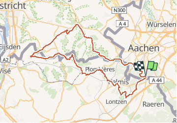
Trail Mountain bike of 78 km to be discovered at North Rhine-Westphalia, Städteregion Aachen, Aachen. This trail is proposed by francois58.
Description
Boucle VTC sur les 3 frontières. 200 m un peu moins praticables en VTC au Bois de Laschet (Teuven). Paysages très variés (forets, vergers, prairies)
Positioning
Country:
Germany
Region :
North Rhine-Westphalia
Department/Province :
Städteregion Aachen
Municipality :
Aachen
Location:
Aachen-Mitte
Start:(Dec)
Start:(UTM)
294619 ; 5623181 (32U) N.
Comments
Trails nearby
![Trail Walking Raeren - 2023-09-21_15h54m11_392.gpx.xml - Photo](https://media.geolcdn.com/t/375/260/3a31813f-998d-4148-baa8-502439fc02b8.jpg&format=jpg&maxdim=2)
![Walking Walking](https://static1.geolcdn.com/sitytour/trail-icons/101.png)
2023-09-21_15h54m11_392.gpx.xml
Walking
Medium
(1)
Raeren,
Wallonia,
Liège,
Belgium
![](/images/other/stat-length.png)
13.2 km | 17.3 km-effort
3h 55min
![](https://static1.geolcdn.com/siteimages/upload/files/16400158638029165_repeat_loop_refresh_sync_direction_icon.png)
Yes
![Trail Walking Aachen - Aix-la-Chapelle - Photo](https://media.geolcdn.com/t/375/260/19678e47-68ef-4997-bad3-67eb75fafd82.jpg&format=jpg&maxdim=2)
![Walking Walking](https://static1.geolcdn.com/sitytour/trail-icons/101.png)
Aix-la-Chapelle
Walking
Easy
(1)
Aachen,
North Rhine-Westphalia,
Städteregion Aachen,
Germany
![](/images/other/stat-length.png)
11.4 km | 15.4 km-effort
3h 30min
![](https://static1.geolcdn.com/siteimages/upload/files/16400158638029165_repeat_loop_refresh_sync_direction_icon.png)
Yes
![Trail Walking Aachen - Aix-la-Chapelle - Photo](https://media.geolcdn.com/t/375/260/efbe95f3-eeed-42aa-9acc-74aad4d18b78.jpg&format=jpg&maxdim=2)
![Walking Walking](https://static1.geolcdn.com/sitytour/trail-icons/101.png)
Aix-la-Chapelle
Walking
Easy
(1)
Aachen,
North Rhine-Westphalia,
Städteregion Aachen,
Germany
![](/images/other/stat-length.png)
11.1 km | 13.4 km-effort
3h 2min
![](https://static1.geolcdn.com/siteimages/upload/files/16400158638029165_repeat_loop_refresh_sync_direction_icon.png)
Yes
![Trail Walking Raeren - 2022-01-18_14h11m36_lichtenbusch - Photo](https://media.geolcdn.com/t/375/260/83311396-e126-40d9-b822-9da5f0d28323.jpg&format=jpg&maxdim=2)
![Walking Walking](https://static1.geolcdn.com/sitytour/trail-icons/101.png)
2022-01-18_14h11m36_lichtenbusch
Walking
Easy
(2)
Raeren,
Wallonia,
Liège,
Belgium
![](/images/other/stat-length.png)
14.8 km | 17 km-effort
3h 52min
![](https://static1.geolcdn.com/siteimages/upload/files/16400158638029165_repeat_loop_refresh_sync_direction_icon.png)
Yes
![Trail Walking Raeren - 2021-04-02_18h39m41_975 - Photo](https://media.geolcdn.com/t/375/260/4dbde2fb-33e3-4e75-84b3-1404a45e04cc.jpg&format=jpg&maxdim=2)
![Walking Walking](https://static1.geolcdn.com/sitytour/trail-icons/101.png)
2021-04-02_18h39m41_975
Walking
Easy
(1)
Raeren,
Wallonia,
Liège,
Belgium
![](/images/other/stat-length.png)
14.6 km | 17.8 km-effort
4h 2min
![](https://static1.geolcdn.com/siteimages/upload/files/16400158638029165_repeat_loop_refresh_sync_direction_icon.png)
Yes
![Trail Walking Kelmis - 20200730 - Les 3 Bornes 7.3 Km - Photo](https://media.geolcdn.com/t/375/260/ab7b3f98-4235-4a73-ba70-1bedd5c785f3.jpg&format=jpg&maxdim=2)
![Walking Walking](https://static1.geolcdn.com/sitytour/trail-icons/101.png)
20200730 - Les 3 Bornes 7.3 Km
Walking
Difficult
(1)
Kelmis,
Wallonia,
Liège,
Belgium
![](/images/other/stat-length.png)
7.4 km | 10.4 km-effort
1h 50min
![](https://static1.geolcdn.com/siteimages/upload/files/16400158638029165_repeat_loop_refresh_sync_direction_icon.png)
Yes
![Trail Walking Raeren - Venn trilogie (2eme étape) - Photo](https://media.geolcdn.com/t/375/260/27f84523-0a25-4d22-8ea7-8cee03cc185d.jpg&format=jpg&maxdim=2)
![Walking Walking](https://static1.geolcdn.com/sitytour/trail-icons/101.png)
Venn trilogie (2eme étape)
Walking
Easy
(1)
Raeren,
Wallonia,
Liège,
Belgium
![](/images/other/stat-length.png)
21 km | 25 km-effort
4h 15min
![](https://static1.geolcdn.com/siteimages/upload/files/16400158638029165_repeat_loop_refresh_sync_direction_icon.png)
No
![Trail Walking Kelmis - Venn Trilogie (1er étape) - Photo](https://media.geolcdn.com/t/375/260/1309a595-2e15-4d31-9259-ac0f30e3e1c8.jpg&format=jpg&maxdim=2)
![Walking Walking](https://static1.geolcdn.com/sitytour/trail-icons/101.png)
Venn Trilogie (1er étape)
Walking
Medium
(1)
Kelmis,
Wallonia,
Liège,
Belgium
![](/images/other/stat-length.png)
25 km | 30 km-effort
5h 0min
![](https://static1.geolcdn.com/siteimages/upload/files/16400158638029165_repeat_loop_refresh_sync_direction_icon.png)
No
![Trail Walking Raeren - RB-Lg-30_Hauset_via-racc-2 - Photo](https://media.geolcdn.com/t/375/260/ext.jpg?maxdim=2&url=https%3A%2F%2Fservices.sitytrail.com%2FGeolivesWS%2FDownloadMedia.ashx%3FTrailID%3D402105%26Media%3Df4d2b2db-afd2-4d70-8342-c9642a40cdea.jpg)
![Walking Walking](https://static1.geolcdn.com/sitytour/trail-icons/101.png)
RB-Lg-30_Hauset_via-racc-2
Walking
(3)
Raeren,
Wallonia,
Liège,
Belgium
![](/images/other/stat-length.png)
13.3 km | 15.9 km-effort
3h 37min
![](https://static1.geolcdn.com/siteimages/upload/files/16400158638029165_repeat_loop_refresh_sync_direction_icon.png)
Yes