![](/images/other/stat-length.png)
![Trail Walking Longueville - Provins depuis Longueville - Photo](https://media.geolcdn.com/t/1900/400/ext.pjpeg?maxdim=2&url=https%3A%2F%2Fstatic1.geolcdn.com%2Fsiteimages%2Fupload%2Ffiles%2F1553511878bg_sport_marche.png)
Provins depuis Longueville
dmj41
User
![Length](/images/other/stat-length.png)
Length
10.8 km
![Max alt](https://static1.geolcdn.com/siteimages/upload/files/1508320355ic_sort_altitude_max_24dp.png)
Max alt
142 m
![Uphill gradient](https://static1.geolcdn.com/siteimages/upload/files/1508320355ic_sort_den_pos_24dp.png)
Uphill gradient
252 m
![Km-Effort](/images/other/stat-length.png)
Km-Effort
14 km
![Min alt](https://static1.geolcdn.com/siteimages/upload/files/1508320355ic_sort_altitude_min_24dp.png)
Min alt
73 m
![Downhill gradient](https://static1.geolcdn.com/siteimages/upload/files/1508320355ic_sort_den_neg_24dp.png)
Downhill gradient
207 m
![Boucle](https://static1.geolcdn.com/siteimages/upload/files/16400158638029165_repeat_loop_refresh_sync_direction_icon.png)
Boucle
No
Creation date :
2022-11-01 17:31:07.928
Updated on :
2022-11-10 08:46:33.575
![Walking](https://static1.geolcdn.com/sitytour/trail-icons/101.png)
2h19
Difficulty : Medium
![Scan this QR Code to open this trail in the SityTrail application](https://capi.geolives.com/qq0zvz2zws4bq2lad0pu/sitytour/trails/3443843/qr.png?size=200)
FREE GPS app for hiking
About
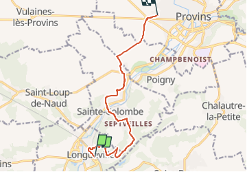
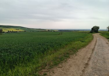
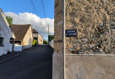
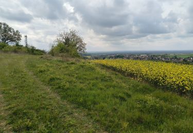
Trail Walking of 10.8 km to be discovered at Ile-de-France, Seine-et-Marne, Longueville. This trail is proposed by dmj41.
Description
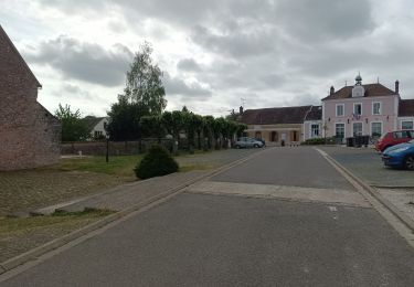
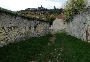
Rando en ligne. De la gare de Longueville jusqu'à la Cité Médievale de Provins.
En passant par Septveilles, Ste Colombes ...
Arrivée à l'aire de Pique-nique près de la Porte St Jean.
Positioning
Country:
France
Region :
Ile-de-France
Department/Province :
Seine-et-Marne
Municipality :
Longueville
Location:
Unknown
Start:(Dec)
Start:(UTM)
518428 ; 5373438 (31U) N.
Comments
Trails nearby
![Trail On foot Saint-Loup-de-Naud - Boucle 32 km St Loup de Naud - Provins - Longueville - Photo](https://media.geolcdn.com/t/375/260/df15ee12-dcdc-4ad0-a966-89837b47f43d.jpg&format=jpg&maxdim=2)
![On foot On foot](https://static1.geolcdn.com/sitytour/trail-icons/100.png)
Boucle 32 km St Loup de Naud - Provins - Longueville
On foot
Difficult
Saint-Loup-de-Naud,
Ile-de-France,
Seine-et-Marne,
France
![](/images/other/stat-length.png)
32 km | 38 km-effort
8h 31min
![](https://static1.geolcdn.com/siteimages/upload/files/16400158638029165_repeat_loop_refresh_sync_direction_icon.png)
Yes
![Trail Walking Savins - Sognolles en Montois - Photo](https://media.geolcdn.com/t/375/260/ext.jpg?maxdim=2&url=https%3A%2F%2Fstatic1.geolcdn.com%2Fsiteimages%2Fupload%2Ffiles%2F1553511878bg_sport_marche.png)
![Walking Walking](https://static1.geolcdn.com/sitytour/trail-icons/101.png)
Sognolles en Montois
Walking
Medium
(1)
Savins,
Ile-de-France,
Seine-et-Marne,
France
![](/images/other/stat-length.png)
16.2 km | 19.3 km-effort
4h 30min
![](https://static1.geolcdn.com/siteimages/upload/files/16400158638029165_repeat_loop_refresh_sync_direction_icon.png)
Yes
![Trail Walking Gouaix - Petite rando bois de GOUAIX - Photo](https://media.geolcdn.com/t/375/260/f63a3c99-a328-4150-89d5-34b69c07ecbd.jpg&format=jpg&maxdim=2)
![Walking Walking](https://static1.geolcdn.com/sitytour/trail-icons/101.png)
Petite rando bois de GOUAIX
Walking
Easy
Gouaix,
Ile-de-France,
Seine-et-Marne,
France
![](/images/other/stat-length.png)
9.1 km | 12 km-effort
2h 10min
![](https://static1.geolcdn.com/siteimages/upload/files/16400158638029165_repeat_loop_refresh_sync_direction_icon.png)
Yes
![Trail Walking Soisy-Bouy - Rando bois de Soisy Bouy - Photo](https://media.geolcdn.com/t/375/260/acc36a9f-7065-41bd-abcf-adaf6bfb7bd5.jpg&format=jpg&maxdim=2)
![Walking Walking](https://static1.geolcdn.com/sitytour/trail-icons/101.png)
Rando bois de Soisy Bouy
Walking
Medium
Soisy-Bouy,
Ile-de-France,
Seine-et-Marne,
France
![](/images/other/stat-length.png)
14.1 km | 18.6 km-effort
3h 25min
![](https://static1.geolcdn.com/siteimages/upload/files/16400158638029165_repeat_loop_refresh_sync_direction_icon.png)
Yes
![Trail Walking Gouaix - petite randonnée bois de GOUAIX - Photo](https://media.geolcdn.com/t/375/260/bc3fc83b-b081-4752-beab-d7a4400873bb.jpg&format=jpg&maxdim=2)
![Walking Walking](https://static1.geolcdn.com/sitytour/trail-icons/101.png)
petite randonnée bois de GOUAIX
Walking
Easy
Gouaix,
Ile-de-France,
Seine-et-Marne,
France
![](/images/other/stat-length.png)
4.4 km | 5.8 km-effort
1h 9min
![](https://static1.geolcdn.com/siteimages/upload/files/16400158638029165_repeat_loop_refresh_sync_direction_icon.png)
Yes
![Trail sport Provins - Provins - Photo](https://media.geolcdn.com/t/375/260/ext.jpg?maxdim=2&url=https%3A%2F%2Fsecurestorage.geolives.com%2Fsitytour%2Ftrail-bg%2Fdefault.jpg)
Provins
sport
Very easy
(1)
Provins,
Ile-de-France,
Seine-et-Marne,
France
![](/images/other/stat-length.png)
6.4 km | 7.3 km-effort
Unknown
![](https://static1.geolcdn.com/siteimages/upload/files/16400158638029165_repeat_loop_refresh_sync_direction_icon.png)
No
![Trail Walking Saint-Loup-de-Naud - Églises médiévales au sud de Provins. - Photo](https://media.geolcdn.com/t/375/260/793f259a-7de3-4381-917c-b5c5c9c56f3d.jpg&format=jpg&maxdim=2)
![Walking Walking](https://static1.geolcdn.com/sitytour/trail-icons/101.png)
Églises médiévales au sud de Provins.
Walking
Very difficult
Saint-Loup-de-Naud,
Ile-de-France,
Seine-et-Marne,
France
![](/images/other/stat-length.png)
19.6 km | 24 km-effort
4h 50min
![](https://static1.geolcdn.com/siteimages/upload/files/16400158638029165_repeat_loop_refresh_sync_direction_icon.png)
Yes
![Trail Walking Provins - Remparts de Provins - Photo](https://media.geolcdn.com/t/375/260/c2afd125-b68f-4d47-b301-c786db1d431f.jpg&format=jpg&maxdim=2)
![Walking Walking](https://static1.geolcdn.com/sitytour/trail-icons/101.png)
Remparts de Provins
Walking
Provins,
Ile-de-France,
Seine-et-Marne,
France
![](/images/other/stat-length.png)
9.1 km | 10.6 km-effort
2h 17min
![](https://static1.geolcdn.com/siteimages/upload/files/16400158638029165_repeat_loop_refresh_sync_direction_icon.png)
Yes
![Trail Walking Provins - JC 11 7.6 km Provins - Photo](https://media.geolcdn.com/t/375/260/a3017967-cfd3-454c-836d-6ee0016e53c9.jpg&format=jpg&maxdim=2)
![Walking Walking](https://static1.geolcdn.com/sitytour/trail-icons/101.png)
JC 11 7.6 km Provins
Walking
Difficult
Provins,
Ile-de-France,
Seine-et-Marne,
France
![](/images/other/stat-length.png)
7.6 km | 8.9 km-effort
2h 11min
![](https://static1.geolcdn.com/siteimages/upload/files/16400158638029165_repeat_loop_refresh_sync_direction_icon.png)
Yes