![](/images/other/stat-length.png)
![Trail Walking Aywaille - CANI-RADO TOUR (boucle, le torrent les 2 ruisseaux et la rivière) - Photo](https://media.geolcdn.com/t/1900/400/ext.pjpeg?maxdim=2&url=https%3A%2F%2Fstatic1.geolcdn.com%2Fsiteimages%2Fupload%2Ffiles%2F1553511878bg_sport_marche.png)
CANI-RADO TOUR (boucle, le torrent les 2 ruisseaux et la rivière)
© OpenStreetMap contributors
![Walking](https://static1.geolcdn.com/sitytour/trail-icons/101.png)
Walking
6h00
Difficulty : Medium
![Length](/images/other/stat-length.png)
Length
14.9 km
![Max alt](https://static1.geolcdn.com/siteimages/upload/files/1508320355ic_sort_altitude_max_24dp.png)
Max alt
477 m
![Uphill gradient](https://static1.geolcdn.com/siteimages/upload/files/1508320355ic_sort_den_pos_24dp.png)
Uphill gradient
387 m
![Km-Effort](/images/other/stat-length.png)
Km-Effort
20 km
![Min alt](https://static1.geolcdn.com/siteimages/upload/files/1508320355ic_sort_altitude_min_24dp.png)
Min alt
154 m
![Downhill gradient](https://static1.geolcdn.com/siteimages/upload/files/1508320355ic_sort_den_neg_24dp.png)
Downhill gradient
392 m
![Boucle](https://static1.geolcdn.com/siteimages/upload/files/16400158638029165_repeat_loop_refresh_sync_direction_icon.png)
Boucle
Yes
Creation date :
2022-09-04 09:05:44.326
Updated on :
2024-09-21 17:08:02.002
![Walking](https://static1.geolcdn.com/sitytour/trail-icons/101.png)
6h00
Difficulty : Medium
![Scan this QR Code to open this trail in the SityTrail application](https://capi.geolives.com/qq0zvz2zws4bq2lad0pu/sitytour/trails/3442842/qr.png?size=200)
FREE GPS app for hiking
About
Trail Walking of 14.9 km to be discovered at Wallonia, Liège, Aywaille. This trail is proposed by Godasses et Grosses Pattes.
Description
Le Ninglinspo, les Blanches Pierres,
le Chefna et les fond de Quarreux (l'Amblève).
une randonnée entre ruisseaux forêt et rivière pour s'évader du tumulte de la ville.
a parcourir sans modération.
Positioning
Country:
Belgium
Region :
Wallonia
Department/Province :
Liège
Municipality :
Aywaille
Location:
Unknown
Start:(Dec)
Start:(UTM)
694707 ; 5594345 (31U) N.
Comments
Trails nearby
![Trail Walking Theux - RB-Lg-24_La-Reid_via-racc-1 - Photo](https://media.geolcdn.com/t/375/260/ext.jpg?maxdim=2&url=https%3A%2F%2Fservices.sitytrail.com%2FGeolivesWS%2FDownloadMedia.ashx%3FTrailID%3D400924%26Media%3De46f0d15-4872-47d2-9c6f-9e812d51cefb.jpg)
![Walking Walking](https://static1.geolcdn.com/sitytour/trail-icons/101.png)
RB-Lg-24_La-Reid_via-racc-1
Walking
(11)
Theux,
Wallonia,
Liège,
Belgium
![](/images/other/stat-length.png)
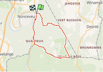
15.9 km | 21 km-effort
4h 50min
![](https://static1.geolcdn.com/siteimages/upload/files/16400158638029165_repeat_loop_refresh_sync_direction_icon.png)
Yes
![Trail Walking Theux - RB-Lg-24_La-Reid - Photo](https://media.geolcdn.com/t/375/260/ext.jpg?maxdim=2&url=https%3A%2F%2Fservices.sitytrail.com%2FGeolivesWS%2FDownloadMedia.ashx%3FTrailID%3D400922%26Media%3De46f0d15-4872-47d2-9c6f-9e812d51cefb.jpg)
![Walking Walking](https://static1.geolcdn.com/sitytour/trail-icons/101.png)
![Trail Walking Aywaille - RB-Lg-12 - De Sougné-Remouchamps à Deigné et retour - Photo](https://media.geolcdn.com/t/375/260/ext.jpg?maxdim=2&url=https%3A%2F%2Fservices.sitytrail.com%2FGeolivesWS%2FDownloadMedia.ashx%3FTrailID%3D179570%26Media%3D1074d230-2da3-49cf-8210-a5f6b46fd870.jpg)
![Walking Walking](https://static1.geolcdn.com/sitytour/trail-icons/101.png)
RB-Lg-12 - De Sougné-Remouchamps à Deigné et retour
Walking
Difficult
(9)
Aywaille,
Wallonia,
Liège,
Belgium
![](/images/other/stat-length.png)
24 km | 34 km-effort
7h 39min
![](https://static1.geolcdn.com/siteimages/upload/files/16400158638029165_repeat_loop_refresh_sync_direction_icon.png)
Yes
![Trail Walking Aywaille - aywaille . florzé . martinrive . septroux . aywaille - Photo](https://media.geolcdn.com/t/375/260/8275975a-b8e8-47c1-9fb9-0580e1d080c9.jpg&format=jpg&maxdim=2)
![Walking Walking](https://static1.geolcdn.com/sitytour/trail-icons/101.png)
aywaille . florzé . martinrive . septroux . aywaille
Walking
Easy
(6)
Aywaille,
Wallonia,
Liège,
Belgium
![](/images/other/stat-length.png)
11.1 km | 15.4 km-effort
2h 48min
![](https://static1.geolcdn.com/siteimages/upload/files/16400158638029165_repeat_loop_refresh_sync_direction_icon.png)
Yes
![Trail Walking Aywaille - Petite remontée du Ninglispo - Photo](https://media.geolcdn.com/t/375/260/ext.jpg?maxdim=2&url=https%3A%2F%2Fservices.sitytrail.com%2FGeolivesWS%2FDownloadMedia.ashx%3FTrailID%3D536482%26Media%3D20160311161707.jpg)
![Walking Walking](https://static1.geolcdn.com/sitytour/trail-icons/101.png)
Petite remontée du Ninglispo
Walking
Medium
(9)
Aywaille,
Wallonia,
Liège,
Belgium
![](/images/other/stat-length.png)
6.7 km | 9.7 km-effort
2h 11min
![](https://static1.geolcdn.com/siteimages/upload/files/16400158638029165_repeat_loop_refresh_sync_direction_icon.png)
Yes
![Trail Walking Aywaille - RB-LG-12 - Raccourci 2 - Photo](https://media.geolcdn.com/t/375/260/ext.jpg?maxdim=2&url=https%3A%2F%2Fservices.sitytrail.com%2FGeolivesWS%2FDownloadMedia.ashx%3FTrailID%3D209433%26Media%3D1f1ef83d-c0c7-4521-b15a-02c5e9e7c1f1.jpg)
![Walking Walking](https://static1.geolcdn.com/sitytour/trail-icons/101.png)
RB-LG-12 - Raccourci 2
Walking
Difficult
(6)
Aywaille,
Wallonia,
Liège,
Belgium
![](/images/other/stat-length.png)
17 km | 25 km-effort
5h 46min
![](https://static1.geolcdn.com/siteimages/upload/files/16400158638029165_repeat_loop_refresh_sync_direction_icon.png)
Yes
![Walking Walking](https://static1.geolcdn.com/sitytour/trail-icons/101.png)
20220717 - HUWAO La Reid - 7 Km
Walking
Medium
(2)
Theux,
Wallonia,
Liège,
Belgium
![](/images/other/stat-length.png)
7 km | 9.5 km-effort
2h 34min
![](https://static1.geolcdn.com/siteimages/upload/files/16400158638029165_repeat_loop_refresh_sync_direction_icon.png)
Yes
![Trail Walking Aywaille - 2021-04-23_12h03m48_1081 - Photo](https://media.geolcdn.com/t/375/260/fc604b5e-e950-4941-952b-ecd138cbf420.jpg&format=jpg&maxdim=2)
![Walking Walking](https://static1.geolcdn.com/sitytour/trail-icons/101.png)
2021-04-23_12h03m48_1081
Walking
Medium
(1)
Aywaille,
Wallonia,
Liège,
Belgium
![](/images/other/stat-length.png)
17.3 km | 24 km-effort
5h 25min
![](https://static1.geolcdn.com/siteimages/upload/files/16400158638029165_repeat_loop_refresh_sync_direction_icon.png)
Yes
![Trail Walking Aywaille - 2021-02-21_16h28m36_1382 - Photo](https://media.geolcdn.com/t/375/260/73151627-72a6-4506-ac77-59fc8213a179.jpg&format=jpg&maxdim=2)
![Walking Walking](https://static1.geolcdn.com/sitytour/trail-icons/101.png)
2021-02-21_16h28m36_1382
Walking
Medium
(1)
Aywaille,
Wallonia,
Liège,
Belgium
![](/images/other/stat-length.png)
15.7 km | 22 km-effort
4h 53min
![](https://static1.geolcdn.com/siteimages/upload/files/16400158638029165_repeat_loop_refresh_sync_direction_icon.png)
Yes